4 Old Guildford Road, Broadbridge Heath, Horsham, RH12 3JU
About 4 Old Guildford Road
4 Old Guildford Road is a four-bedroom property in Broadbridge Heath, Horsham, Horsham (RH12 3JU). It has council tax band F.
Held since February 2011 — that's 15 years off the open market, well above the local norm.
What this property has
Inside
- Bedrooms4
Everything you need to know about 4 Old Guildford Road
The true value, the hidden risks and the full sale history, in one report.
Pick your report · every report is £14.99
One time fee only - money back guarantee

The data behind every report


Energy performance
No EPC on record
This property doesn't have an Energy Performance Certificate yet. An EPC is required to sell or let — and unlocks our automated valuation.
Get a survey for this property
Level 2 HomeBuyer Report
We've checked 10 risk factors against the available data for this property and believe a Level 2 HomeBuyer Report could be a suitable option for you.
Planning history
4 Old Guildford Road has no planning applications on record.
But the area is active
10 notable applications nearby — larger schemes and conversions that could reshape the street. The report maps them all.
Sales history & valuation
£459,950
Recorded with HM Land Registry.
Sales timeline
21 February 2011Most recent
£459,950
Median price across the last 5 sales in RH12 3JU: £490,000 (2025–2022).
Nearby sales in RH12 3JU
54 Old Guildford Road, Broadbridge Heath, Horsham, RH12 3JU
Sold Sept 2025
£490,00048 Old Guildford Road, Broadbridge Heath, Horsham, RH12 3JU
Sold Dec 2024
£330,00030 Old Guildford Road, Broadbridge Heath, Horsham, RH12 3JU
Sold Jun 2024
£540,00028 Old Guildford Road, Broadbridge Heath, Horsham, RH12 3JU
Sold Aug 2022
£455,3606 Old Guildford Road, Broadbridge Heath, Horsham, RH12 3JU
Sold Jan 2022
£830,000
Everything you need to know about 4 Old Guildford Road
The true value, the hidden risks and the full sale history, in one report.
Pick your report · every report is £14.99
One time fee only - money back guarantee
The data behind every report
Similar properties nearby
1 Buckhurst Cottages, Church Street, Rudgwick
RH12 3EZ
1 Chantler Lane, Broadbridge Heath
RH12 3TW
1 Bell Road, Warnham
RH12 3QJ
1 Benlands Cottages, Northlands Road, Warnham
RH12 3SQ
1 Brookhurst Field, Foxholes, Rudgwick
RH12 3DQ
1 Barley Mews, Rudgwick
RH12 3XL
1 Buck Way, Broadbridge Heath
RH12 3UH
1 Arundene Cottage, Loxwood Road, Rudgwick
RH12 3BT
The neighbourhood at a glance
Crime
2/mo
Steady year-on-year across the wider district.
Nearest stop
0.1 km
Church Road — bus stop.
Closest school
0.3 km
Shelley Primary School. 10 schools nearby.
Go deeper on the local area
A Local Area report breaks down crime, transport links, schools and air quality in depth.
Road noise across the postcode
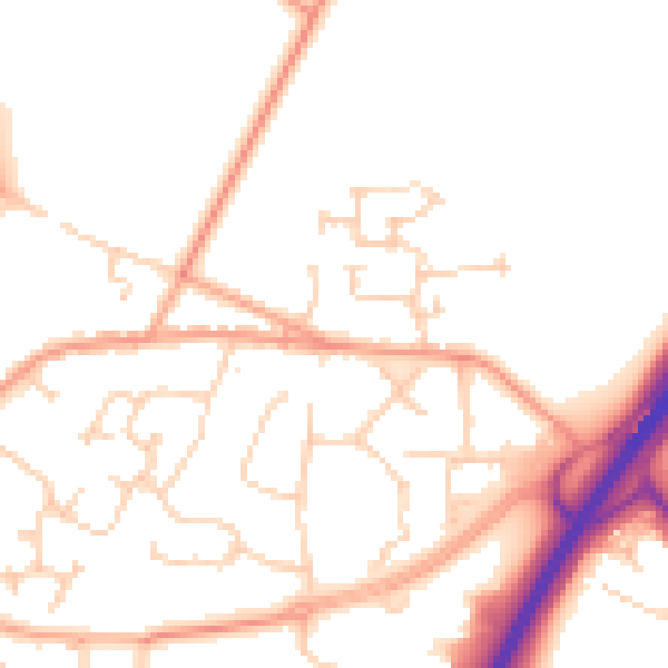
Daytime· 07:00 – 23:00
50.8dB

Night-time· 23:00 – 07:00
41.1dB