83a, North Western Avenue, Watford, WD25 0AG
About 83a
83a is a two-bedroom detached house in Watford (WD25 0AG). It has a recorded floor area of 45 m² (around 487 sq ft), construction records dating it to 1930-1949 and council tax band B. At 45 m² this is the 5th smallest of 30 units on EPC record in the building, where floor areas span 42–140 m². The building's EPC ratings span E to B across 30 units on file. The latest certificate (January 2009) shows a D (score 55), a step below the typical UK home. The recommended improvements would push it to C (score 69). The latest certificate is from January 2009, so improvements made since then won't be reflected.
Last sold in August 2017, so it's been off the market for around 9 years. Across the public record there are 4 sales, relatively high churn for a single property. Across 1998–2017, sale prices on this property compounded at 7.9% per year. On a £-per-square-foot basis, the last sale (£586/sq ft) was about 126% above the typical sold price in the postcode. 3 planning records sit against the property, 0 approved, 1 refused. At 45 m² it's 20.7% smaller than the typical home in the postcode (57 m² median across 29 EPCs).
What this property has
Inside
- Bedrooms2
Outside
- Private gardenYes
- DrivewayYes
Building
- Central heatingYes
Everything you need to know about 83a
The true value, the hidden risks and the full sale history, in one report.
Pick your report · from £14.99
One time fee only - money back guarantee

The data behind every report


Energy performance
83a's EPC is over a decade old — improvements since won't be reflected.
EPC Expired
This certificate is over 10 years old and is no longer valid.Expired 20 Jan 2019
EPC Rating
Certificate validity
Expired on 20 January 2019

Get a survey for this property
Level 3 Building Survey
Because the property has solid (non-cavity) walls, we believe a Level 3 building survey should be considered.
From £885 · Includes VAT
Planning history
A a loft conversion application was refused at 83a in 2023.
3 applications on record at 83a, North Western Avenue, Watford, WD25 0AG
- Jun 2020OutbuildingFullOutcome in report
Erection of a garage/outbuilding in the rear garden.
- Documents
- 10 docs on file
- Reference
- 20/00449/FUL
- More recent applications — locked
- Loft ConversionMay 2024Decision
- Loft ConversionJul 2023Decision
Unlock 83a, North Western Avenue, Watford, WD25 0AG's full planning history
You're seeing the shape of it. The report has the substance.
- Every decision — granted, refused or withdrawn (3 on record)
- All 3 applications on this property in full, plus 2 notable nearby
- The 37 documents, officer reports & conditions
- What the pattern means for extending or converting here
One time fee only - money back guarantee
Sales history & valuation
83a has more than quadrupled in price since its earliest registered sale in 1998.
£289,000
Modelled from EPC, postcode comparables and a sale-price growth of 7.9% per year over 19 years.
£285,000
Growth on file: 7.9% per year over 19 years.
Sales timeline
29 August 2017Most recent
£285,000
+29.5%over 2 years18 February 2015
£220,000
+39.2%over 5 years27 November 2009
£158,000
+134.1%over 11 years1 October 1998
£67,500
Median price across the last 5 sales in WD25 0AG: £385,000 (2026–2022).
Nearby sales in WD25 0AG
71 North Western Avenue, Watford, WD25 0AG
Sold May 2026
£550,00095b, North Western Avenue, Watford, WD25 0AG
Sold Mar 2025
£330,00085 North Western Avenue, Watford, WD25 0AG
Sold Jan 2024
£385,00075 North Western Avenue, Watford, WD25 0AG
Sold Oct 2022
£425,00095a, North Western Avenue, Watford, WD25 0AG
Sold Mar 2021
£300,000
Versus other North Western Avenue homes
Price per m² for 83a runs comfortably ahead of the street norm.
Price per m²
£6,305
Street avg £3,341
Floor Area
45 m²
Street avg 47 m²
Habitable Rooms
3 rooms
Street avg 2 rooms
CO₂ Emissions
3.6 t/year
Street avg 2.7 t/year
Everything you need to know about 83a
The true value, the hidden risks and the full sale history, in one report.
Pick your report · from £14.99
One time fee only - money back guarantee
The data behind every report
Similar properties nearby
1 Alder Walk
WD25 0RT
1 Cedar Wood Drive
WD25 0RR
1 Aspen Park Drive
WD25 0RS
1 Avon Close
WD25 0DN
1 Derwent Close
WD25 0NQ
1 Austin Villas, Woodside Road
WD25 0GD
1 Bramble Close
WD25 0HF
1 All Saints Crescent
WD25 0LU
The neighbourhood at a glance
Rail-style transport is unusually close for this postcode.
Crime
214/mo
Falling year-on-year across the wider district.
Nearest stop
0.2 km
Library — bus stop.
Closest school
0.5 km
Cherry Tree Primary School. 29 schools nearby.
Go deeper on the local area
A Local Area report breaks down crime, transport links, schools and air quality in depth.
Road noise across the postcode
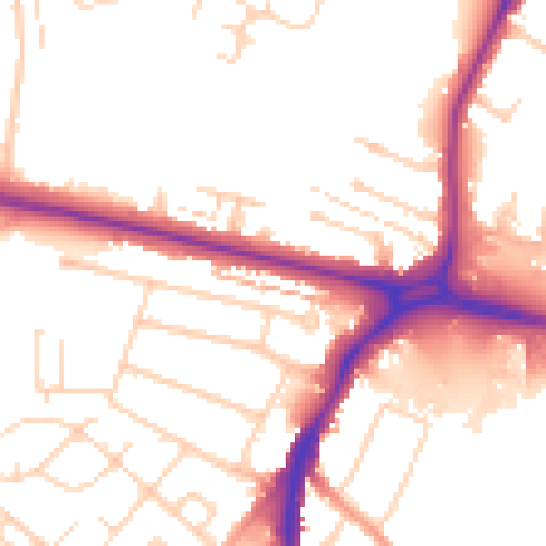
Daytime· 07:00 – 23:00
52.6dB

Night-time· 23:00 – 07:00
43.6dB