9 Groby Road, Manchester, M21 8AF
About 9 Groby Road
9 Groby Road is a four-bedroom semi-detached house in Manchester (M21 8AF). It has a recorded floor area of 126 m² (around 1356 sq ft), construction records dating it to before 1900 and council tax band D. The latest certificate (January 2018) shows a D (score 55), a step below the typical UK home. Other recorded features include a basement.
Across 2003–2018, sale prices on this property compounded at 4.5% per year. Today's modelled estimate of £684,000 is 44% above the 2018 sale price. On a £-per-square-foot basis, the last sale (£350/sq ft) was about 48% above the typical sold price in the postcode. Last sold in May 2018, so it's been off the market for around 8 years. At 126 m² it's 22.5% smaller than the typical home in the postcode (163 m² median across 8 EPCs).
Know exactly what you're buying at 9 Groby Road
Before you offer, see what the listing won't tell you, the true value, the red flags and the full history.
Already flagged here
Valuation
against the asking price
Risks
planning & flood
Sold prices
similar homes nearby
Trends
the local market
What this property has
Inside
- Bedrooms4
- Bathrooms2
- CloakroomYes
- EnsuiteYes
- StudyYes
- BasementYes
Outside
- Private gardenSouth-facing
Energy performance
9 Groby Road's carbon output runs well above what efficient homes in the postcode produce.
EPC Rating
Planning history
9 Groby Road has no planning applications on record.
Notable planning nearby
3applications of note in the surrounding area
We flagged 1 thing worth checking at 9 Groby Road
Independent checks surfaced things a buyer would want to understand before offering. The report explains each one in full, with the underlying data and what to ask.
- Larger development activity nearby
30-day money-back guarantee
Sales history & valuation
9 Groby Road valuation sits well clear of the typical sold price in this postcode.
£684,000
Modelled from EPC, postcode comparables and a sale-price growth of 4.5% per year over 14 years.
£475,000
Growth on file: 4.5% per year over 14 years.
Sales timeline
9 May 2018Most recent
£475,000
+63.8%over 12 years20 September 2005
£290,000
+16.0%over 1 year25 November 2003
£249,999
Median price across the last 5 sales in M21 8AF: £565,000 (2023–2016).
Everything we know about 9 Groby Road, in one report
What it's really worth, what could be wrong, and the planning, sales and area data in full.
What we flagged
- Larger development activity nearby

Versus other Groby Road homes
9 Groby Road is notably below the street on habitable rooms.
Price per m²
£3,770
Street avg £3,269
Floor Area
126 m²
Street avg 157 m²
Habitable Rooms
5 rooms
Street avg 7 rooms
CO₂ Emissions
6.5 t/year
Street avg 7.9 t/year
Similar properties nearby
1 Dawlish Road
M21 8XR
1 Clifton Road
M21 8UX
1 Ansdell Avenue
M21 8TP
1 Clovelly Road
M21 8XU
1 Claude Road
M21 8BZ
1 Hartington Road
M21 8UZ
1 Cleveleys Avenue
M21 8TS
1 Limley Grove
M21 8UB
The neighbourhood at a glance
Rail-style transport is unusually close for this postcode.
Nearest stop
0.1 km
Groby Road — bus stop.
Closest school
0.4 km
Chorlton CofE Primary School. 40 schools nearby.
Go deeper on the local area
The full report breaks down crime, transport links, schools and air quality in depth.
Road noise across the postcode
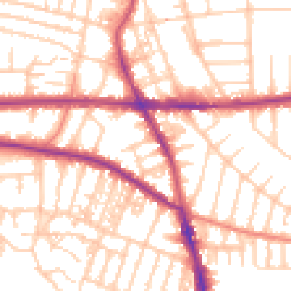
Daytime· 07:00 – 23:00
54.1dB

Night-time· 23:00 – 07:00
43.7dB