14b, Wood Lane, Headingley, Leeds, LS6 2AE
About 14b
14b is a four-bedroom detached house in Headingley, Leeds, Leeds (LS6 2AE). It has a recorded floor area of 149 m² (around 1603 sq ft), construction records dating it to 1976-1982 and council tax band F. It is a listed building, which means external alterations are tightly controlled but it may qualify for heritage tax reliefs. Other recorded features include a conservatory and a self-contained annexe. The latest certificate (October 2009) shows a D (score 63), on the cusp of jumping into the C band. The recommended improvements would push it to C (score 70). The latest certificate is from October 2009, so improvements made since then won't be reflected.
Untraded for 16 years, with the last transfer in December 2010. At 149 m² the property is well over the postcode median (55 m² across 61 EPCs), placing it in the larger end of the local stock. Across 1995–2010, sale prices on this property compounded at 5% per year. Today's modelled estimate of £502,000 sits 60.9% above the 2010 sale of £312,000. One historical planning record sits against the property in 2022.
What this property has
Inside
- Bedrooms4
- Open-plan layoutYes
- Dining roomYes
- Utility roomYes
- EnsuiteYes
- ConservatoryYes
Outside
- Private gardenYes
Building
- Listed buildingYes
Everything you need to know about 14b
The true value, the hidden risks and the full sale history, in one report.
Pick your report · from £14.99
One time fee only - money back guarantee

The data behind every report







Energy performance
14b's carbon output runs well above what efficient homes in the postcode produce.
EPC Expired
This certificate is over 10 years old and is no longer valid.Expired 13 Oct 2019
EPC Rating
Certificate validity
Expired on 13 October 2019

Get a survey for this property
Level 3 Building Survey
Because the property is a listed building, we believe a Level 3 building survey should be considered.
From £1,085 · Includes VAT
Planning history
1 application on record at 14b, Wood Lane, Headingley, Leeds, LS6 2AE
- Oct 2022Tree WorksTreesOutcome in report
T1 Lombardy Poplar - To be removed. It has a heavy lean towards neighbouring house and is within striking distance. T2 Lombardy Poplar - To be reduced by 8 metres.
- Documents
- 5 docs on file
- Reference
- 22/06653/TR
Unlock 14b, Wood Lane, Headingley, Leeds, LS6 2AE's full planning history
You're seeing the shape of it. The report has the substance.
- Every decision — granted, refused or withdrawn (1 on record)
- All 1 application on this property in full, plus 114 notable nearby
- The 5 documents, officer reports & conditions
- What the pattern means for extending or converting here
One time fee only - money back guarantee
Sales history & valuation
14b has more than doubled in price since the earliest registered sale in 1995.
£502,000
Modelled from EPC, postcode comparables and a sale-price growth of 5.0% per year over 16 years.
£312,000
Growth on file: 5.0% per year over 16 years.
Sales timeline
3 December 2010Most recent
£312,000
+115.2%over 15 years10 March 1995
£145,000
Median price across the last 5 sales in LS6 2AE: £285,000 (2024–2016).
Nearby sales in LS6 2AE
Belmont House, 1, 20 Wood Lane, Headingley, Leeds, LS6 2AE
Sold Dec 2024
£475,000Belmont House, 3, 20 Wood Lane, Headingley, Leeds, LS6 2AE
Sold Nov 2024
£365,000Flat 3, 18 Wood Lane, Headingley, Leeds, LS6 2AE
Sold Jan 2024
£191,000Flat 6, 18 Wood Lane, Headingley, Leeds, LS6 2AE
Sold May 2017
£208,000Flat 2, 18 Wood Lane, Headingley, Leeds, LS6 2AE
Sold Aug 2016
£285,000
Everything you need to know about 14b
The true value, the hidden risks and the full sale history, in one report.
Pick your report · from £14.99
One time fee only - money back guarantee
The data behind every report
Similar properties nearby
The neighbourhood at a glance
Crime
314/mo
Steady year-on-year across the wider district.
Nearest stop
0.2 km
St Michaels Church — bus stop.
Closest school
0.1 km
Shire Oak VC Primary School. 35 schools nearby.
Go deeper on the local area
A Local Area report breaks down crime, transport links, schools and air quality in depth.
Road noise across the postcode
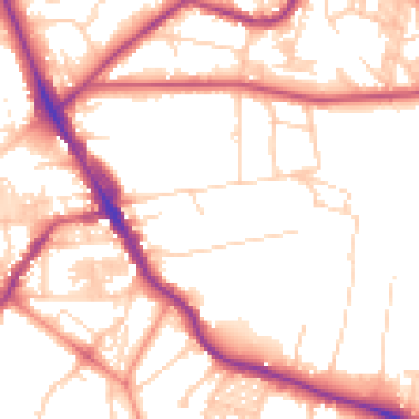
Daytime· 07:00 – 23:00
53.3dB

Night-time· 23:00 – 07:00
43.2dB