89b, Chapel Lane, High Wycombe, HP12 4BS
About 89b
89b is a property in High Wycombe (HP12 4BS). It has a recorded floor area of 43 m² (around 464 sq ft), construction records dating it to 1930-1949 and council tax band B. The latest certificate (August 2011) shows an E (score 47), well below the UK norm with real room to improve. The recommended improvements would lift it to C (score 73), a 2-band jump. Main heating runs on electricity. The latest certificate is from August 2011, so improvements made since then won't be reflected. At 43 m² this is the 10th smallest of 59 units on EPC record in the building, where floor areas span 23–201 m². The building's EPC ratings span F to B across 59 units on file.
At 43 m² it sits well below the postcode median (71 m² across 58 EPCs), making it one of the more compact homes locally. It lags the bulk of the postcode on energy efficiency (less efficient than 74% of similar EPCs). On the market in May 2018 and unlisted since — roughly 8 years. Across the public record there are 5 sales, relatively high churn for a single property. Across 2000–2018, sale prices on this property compounded at 6% per year. On a £-per-square-foot basis, the last sale (£388/sq ft) was about 42.6% above the typical sold price in the postcode.
Everything you need to know about 89b
The true value, the hidden risks and the full sale history, in one report.
Pick your report · every report is £14.99
One time fee only - money back guarantee

The data behind every report


Energy performance
Recommended upgrades on file would lift this property by multiple EPC bands.
EPC Expired
This certificate is over 10 years old and is no longer valid.Expired 11 Aug 2021
EPC Rating
Get a survey for this property
Level 3 Building Survey
Because the property has no mains gas supply, we believe a Level 3 building survey should be considered.
From £820 · Includes VAT
Planning history
89b has no planning applications on record.
But the area is active
2 notable applications nearby — larger schemes and conversions that could reshape the street. The report maps them all.
Sales history & valuation
89b has more than doubled in price since the earliest registered sale in 2000.
£191,000
Modelled from EPC, postcode comparables and a sale-price growth of 6.0% per year over 18 years.
£180,000
Growth on file: 6.0% per year over 18 years.
Sales timeline
3 May 2018Most recent
£180,000
+42.9%over 2 years18 December 2015
£126,000
+32.6%over 3 years16 February 2012
£95,000
-3.1%over 1 year30 September 2010
£98,000
+55.7%over 10 years4 April 2000
£62,950
Median price across the last 5 sales in HP12 4BS: £290,000 (2025–2024).
Nearby sales in HP12 4BS
92 Chapel Lane, High Wycombe, HP12 4BS
Sold Oct 2025
£392,50076 Chapel Lane, High Wycombe, HP12 4BS
Sold Dec 2024
£272,000Flat 2, 99 Chapel Lane, High Wycombe, HP12 4BS
Sold Apr 2024
£175,00066 Chapel Lane, High Wycombe, HP12 4BS
Sold Mar 2024
£290,00084 Chapel Lane, High Wycombe, HP12 4BS
Sold Jan 2024
£425,000
Versus other Chapel Lane homes
89b is notably below the street on epc rating.
Price per m²
£4,171
Street avg £3,864
Floor Area
43 m²
Street avg 49 m²
Habitable Rooms
2 rooms
Street avg 2 rooms
CO₂ Emissions
4.8 t/year
Street avg 1.8 t/year
Everything you need to know about 89b
The true value, the hidden risks and the full sale history, in one report.
Pick your report · every report is £14.99
One time fee only - money back guarantee
The data behind every report
Similar properties nearby
1 Barry Close
HP12 4UE
1 Ashtree House, Elm Road
HP12 4TB
1 Byron House, Sheridan Court
HP12 4SQ
1 Challener Road
HP12 4PW
1 Beech Tree Cottages, Lane End Road
HP12 4JF
1 Christie Close
HP12 4FN
1 Buckmaster Road
HP12 4PE
1 Cressex Close
HP12 4BQ
The neighbourhood at a glance
Daytime road noise here sits well below conversation level — a quiet pocket of the postcode.
Crime
8/mo
Steady year-on-year across the wider district.
Nearest stop
0.0 km
Chapel Lane — bus stop.
Closest school
0.4 km
Millbrook Combined School. 15 schools nearby.
Go deeper on the local area
A Local Area report breaks down crime, transport links, schools and air quality in depth.
Road noise across the postcode
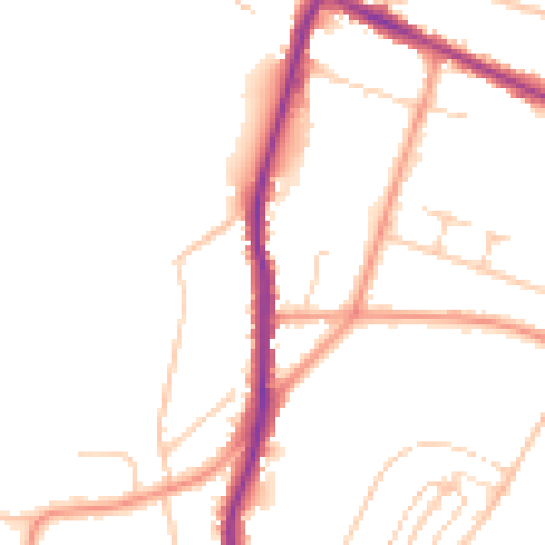
Daytime· 07:00 – 23:00
48.9dB

Night-time· 23:00 – 07:00
40.1dB