53 Briar Road, Watford, WD25 0HW
About 53 Briar Road
53 Briar Road is a four-bedroom semi-detached house in Watford (WD25 0HW). It has a recorded floor area of 90 m² (around 969 sq ft), construction records dating it to 1930-1949 and council tax band D. The latest certificate (May 2012) shows a D (score 67), on the cusp of jumping into the C band. The recommended improvements would lift it to B (score 87), a 2-band jump. The latest certificate is from May 2012, so improvements made since then won't be reflected. Records show the property has been extended at some point in its history.
Last sale on file: £435,000 in December 2019. Across the public record there are 4 sales, relatively high churn for a single property. Across 2004–2019, sale prices on this property compounded at 5% per year. Today's modelled estimate of £513,000 is 17.9% above the 2019 sale price. On a £-per-square-foot basis, the last sale (£449/sq ft) was about 58.8% above the typical sold price in the postcode.
What this property has
Inside
- Bedrooms4
- Bathrooms1
- Dining roomYes
Outside
- Private gardenSouth-facing
- ParkingOff street
Building
- Previously extendedYes
Everything you need to know about 53 Briar Road
The true value, the hidden risks and the full sale history, in one report.
30-day money-back guarantee

The data behind every report


Energy performance
Recommended upgrades on file would lift this property by multiple EPC bands.
EPC Expired
This certificate is over 10 years old and is no longer valid.Expired 08 May 2022
EPC Rating
Planning history
53 Briar Road has no planning applications on record.
Notable planning nearby
2applications of note in the surrounding area
Sales history & valuation
Sale price has at least doubled since 2004.
£513,000
Modelled from EPC, postcode comparables and a sale-price growth of 5.0% per year over 15 years.
£435,000
Growth on file: 5.0% per year over 15 years.
Sales timeline
20 December 2019Most recent
£435,000
+38.1%over 7 years17 July 2012
£315,000
+22.1%over 7 years16 June 2005
£258,000
+24.3%over 7 months3 November 2004
£207,500
Median price across the last 5 sales in WD25 0HW: £515,000 (2025–2018).
Versus other Briar Road homes
On co₂ emissions, 53 Briar Road stands well clear of the street.
Price per m²
£4,833
Street avg £3,838
Floor Area
90 m²
Street avg 99 m²
Habitable Rooms
6 rooms
Street avg 5 rooms
CO₂ Emissions
3.2 t/year
Street avg 4.7 t/year
Everything you need to know about 53 Briar Road
The true value, the hidden risks and the full sale history, in one report.
30-day money-back guarantee
The data behind every report
Similar properties nearby
1 Cypress Walk
WD25 0RY
1 Elderberry Way
WD25 0RW
1 Ennerdale Drive
WD25 0NG
1 Bramble Close
WD25 0HF
1 Austin Villas, Woodside Road
WD25 0GD
1 Ash Close
WD25 0RU
1 Derwent Close
WD25 0NQ
1 All Saints Crescent
WD25 0LU
The neighbourhood at a glance
Crime
4/mo
Steady year-on-year across the wider district.
Nearest stop
0.1 km
Kingswood Road — bus stop.
Closest school
0.6 km
Kingsway Junior School. 27 schools nearby.
Go deeper on the local area
The full report breaks down crime, transport links, schools and air quality in depth.
Road noise across the postcode
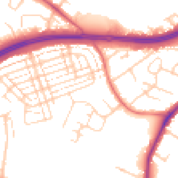
Daytime· 07:00 – 23:00
52.8dB

Night-time· 23:00 – 07:00
44.4dB