220 Leggatts Rise, Watford, WD25 0BL
About 220 Leggatts Rise
220 Leggatts Rise is a three-bedroom end-of-terrace house in Watford (WD25 0BL). It has a recorded floor area of 105 m² (around 1134 sq ft), construction records dating it to 1950-1966 and council tax band C. The latest certificate (December 2008) shows a D (score 66), on the cusp of jumping into the C band. The recommended improvements would push it to C (score 73). The latest certificate is from December 2008, so improvements made since then won't be reflected. Our model identifies extension potential, subject to local planning policy.
Untraded for 17 years, with the last transfer in October 2009. That sale fell during the post-crash dip, which often skews comparisons against later neighbouring sales. Today's modelled estimate of £511,000 sits 127.1% above the 2009 sale of £225,000. On a £-per-square-foot basis, the last sale (£198/sq ft) was about 30% below the postcode norm. At 105 m² it's 15.8% larger than the typical home in the postcode (91 m² median across 19 EPCs).
What this property has
Inside
- Bedrooms3
- Bathrooms2
- Open-plan layoutYes
- CloakroomYes
Outside
- Private gardenYes
- DrivewayYes
Building
- RefurbishedYes
- Extension potentialPossible
Everything you need to know about 220 Leggatts Rise
The true value, the hidden risks and the full sale history, in one report.
30-day money-back guarantee

The data behind every report


Energy performance
220 Leggatts Rise's EPC is over a decade old — improvements since won't be reflected.
EPC Expired
This certificate is over 10 years old and is no longer valid.Expired 22 Dec 2018
EPC Rating
Planning history
220 Leggatts Rise has no planning applications on record.
Notable planning nearby
2applications of note in the surrounding area
Sales history & valuation
The latest sale fell during the post-2008 dip, often a low-water mark in price comparisons.
£511,000
Modelled from EPC, postcode comparables.
£225,000
Recorded with HM Land Registry.
Sales timeline
11 October 2009Most recent
£225,000
Median price across the last 5 sales in WD25 0BL: £456,757 (2025–2021).
Nearby sales in WD25 0BL
Versus other Leggatts Rise homes
Price per m² for 220 Leggatts Rise lags the street by a wide margin.
Price per m²
£2,136
Street avg £4,064
Floor Area
105 m²
Street avg 95 m²
Habitable Rooms
6 rooms
Street avg 5 rooms
CO₂ Emissions
4.3 t/year
Street avg 3.9 t/year
Everything you need to know about 220 Leggatts Rise
The true value, the hidden risks and the full sale history, in one report.
30-day money-back guarantee
The data behind every report
Similar properties nearby
1 Bramble Close
WD25 0HF
1 Austin Villas, Woodside Road
WD25 0GD
1 Derwent Close
WD25 0NQ
1 All Saints Crescent
WD25 0LU
1 Avon Close
WD25 0DN
1 Coopers Mews
WD25 0JD
1 Aspen Park Drive
WD25 0RS
1 Alder Walk
WD25 0RT
The neighbourhood at a glance
Crime
4/mo
Steady year-on-year across the wider district.
Nearest stop
0.2 km
Maytree Crescent — bus stop.
Closest school
0.4 km
Cherry Tree Primary School. 27 schools nearby.
Go deeper on the local area
The full report breaks down crime, transport links, schools and air quality in depth.
Road noise across the postcode
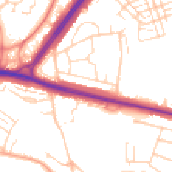
Daytime· 07:00 – 23:00
52.1dB

Night-time· 23:00 – 07:00
42.9dB