27 Malvern Avenue, Harrow, HA2 9EU
About 27 Malvern Avenue
27 Malvern Avenue is a property in Harrow (HA2 9EU). It has council tax band D.
Held since February 2002 — that's 24 years off the open market, well above the local norm. One planning record on file: an extension approved in 2025. Past consents include an extension, meaningful when judging how the property has evolved.
Know exactly what you're buying at 27 Malvern Avenue
Before you offer, see what the listing won't tell you, the true value, the red flags and the full history.
Valuation
against the asking price
Risks
planning & flood
Sold prices
similar homes nearby
Trends
the local market
Energy performance
No EPC on record
This property doesn't have an Energy Performance Certificate yet. An EPC is required to sell or let — and unlocks our automated valuation.
Planning history
27 Malvern Avenue has an approved single-storey rear extension on the planning record.
- Feb 2025ExtensionOutlineIn report
Extension: Single storey · Rear of property
Single storey rear extension: 4.50 metres deep, 2.97 metres maximum height and 2.85 metres high to the eaves
- Reference
- PL/0387/25
What's in 27 Malvern Avenue, Harrow, HA2 9EU's planning history?
Refusals, disputes and full decisions on this property and nearby, in the report.
Sales history & valuation
£174,950
Recorded with HM Land Registry.
Sales timeline
8 February 2002Most recent
£174,950
Median price across the last 5 sales in HA2 9EU: £528,000 (2022–2020).
Everything we know about 27 Malvern Avenue, in one report
What it's really worth, what could be wrong, and the planning, sales and area data in full.
- Am I paying too much?
- Is something wrong with it?
- Is the agent's story true?
- Will it hold its value?

Similar properties nearby
1 Brookside Close, South Harrow
HA2 9AW
1 Bodmin Close, Kings Road
HA2 9LA
1 Mead Field, Kings Road
HA2 9BD
1 Barn Mews, Tithe Farm Avenue
HA2 9AE
1 Jasmine Gardens
HA2 9DE
1 Kings Road
HA2 9HY
1 Mirren Close
HA2 9BG
1 Cornell House, Hamilton Crescent
HA2 9JY
The neighbourhood at a glance
Reported crime in the wider district is trending notably upward year-on-year.
Crime
6/mo
Rising year-on-year across the wider district.
Nearest stop
0.2 km
Alexandra Avenue Health Centre — bus stop.
Closest school
0.3 km
Heathland School. 37 schools nearby.
Go deeper on the local area
The full report breaks down crime, transport links, schools and air quality in depth.
Road noise across the postcode
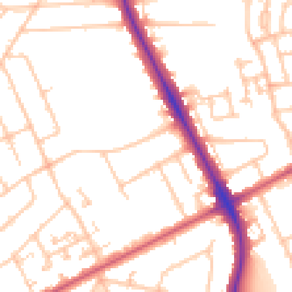
Daytime· 07:00 – 23:00
51.2dB

Night-time· 23:00 – 07:00
40.5dB