45 Ennerdale Drive, Watford, WD25 0NG
About 45 Ennerdale Drive
45 Ennerdale Drive is a three-bedroom end-of-terrace house in Watford (WD25 0NG). It has a recorded floor area of 111 m² (around 1195 sq ft). The latest certificate (August 2013) returns a B (score 82), comfortably above the UK average. The latest certificate is from August 2013, so improvements made since then won't be reflected.
2 planning records sit against the property, 1 approved, 0 refused. Past consents include tree works, meaningful when judging how the property has evolved. Across 2013–2023, sale prices on this property compounded at 5.1% per year. On a £-per-square-foot basis, the last sale (£505/sq ft) was about 73.8% above the typical sold price in the postcode. Last sale on file: £603,000 in March 2023.
What this property has
Inside
- Bedrooms3
- Bathrooms3
- Dining roomYes
- CloakroomYes
- EnsuiteYes
- StudyYes
Outside
- Private gardenSouth-west-facing
- ParkingOff street
Building
- RefurbishedYes
Everything you need to know about 45 Ennerdale Drive
The true value, the hidden risks and the full sale history, in one report.
Pick your report · from £14.99
One time fee only - money back guarantee

The data behind every report







Energy performance
45 Ennerdale Drive's EPC is over a decade old — improvements since won't be reflected.
EPC Expired
This certificate is over 10 years old and is no longer valid.Expired 27 Aug 2023
EPC Rating
Certificate validity
Expired on 27 August 2023

Get a survey for this property
Level 2 HomeBuyer Report
We've checked 10 risk factors against the available data for this property and believe a Level 2 HomeBuyer Report could be a suitable option for you.
From £795 · Includes VAT
Planning history
Planning history at 45 Ennerdale Drive is exclusively tree-management applications — typical for a property with mature trees on or near the plot.
2 applications on record at 45 Ennerdale Drive, Watford, WD25 0NG
- Sept 2021Tree WorksTreesOutcome in report
Works to trees protected by TPO59, Group G7. T11 Oak (refer to sketch plan) has a dangerous branch overhanging 45 Ennerdale Drive garden. Branch circled to be cut at the trunk. T7 and T14 Ash trees (mis-identified as Birch trees) (refer to sketch plan) to be cut back to prevent branches hitting adjacent property (43 Ennerdale Drive)
- Documents
- 8 docs on file
- Reference
- 21/01072/TPO
- More recent applications — locked
- Tree WorksSept 2023Decision
Unlock 45 Ennerdale Drive, Watford, WD25 0NG's full planning history
You're seeing the shape of it. The report has the substance.
- Every decision — granted, refused or withdrawn (2 on record)
- All 2 applications on this property in full, plus 2 notable nearby
- The 14 documents, officer reports & conditions
- What the pattern means for extending or converting here
One time fee only - money back guarantee
Sales history & valuation
Latest sale on 45 Ennerdale Drive was the highest on Land Registry record across the postcode.
£594,000
Modelled from EPC, postcode comparables and a sale-price growth of 5.1% per year over 10 years.
£603,000
Growth on file: 5.1% per year over 10 years.
Sales timeline
9 March 2023Most recent
£603,000
+7.7%over 6 years30 May 2016
£560,000
+49.3%over 2 years29 August 2013
£375,000
Median price across the last 5 sales in WD25 0NG: £505,000 (2025–2022).
Nearby sales in WD25 0NG
Versus other Ennerdale Drive homes
Years Held for 45 Ennerdale Drive lags the street by a wide margin.
Price per m²
£5,432
Street avg £3,955
Floor Area
111 m²
Street avg 98 m²
CO₂ Emissions
1.8 t/year
Street avg 2.0 t/year
Years Held
3 years
Street avg 12 years
Everything you need to know about 45 Ennerdale Drive
The true value, the hidden risks and the full sale history, in one report.
Pick your report · from £14.99
One time fee only - money back guarantee
The data behind every report
Similar properties nearby
1 All Saints Crescent
WD25 0LU
1 Bramble Close
WD25 0HF
1 Austin Villas, Woodside Road
WD25 0GD
1 Derwent Close
WD25 0NQ
1 Coopers Mews
WD25 0JD
1 Cypress Walk
WD25 0RY
1 Avon Close
WD25 0DN
1 Aspen Park Drive
WD25 0RS
The neighbourhood at a glance
Crime
214/mo
Falling year-on-year across the wider district.
Nearest stop
0.4 km
Lamb Close — bus stop.
Closest school
0.6 km
St Catherine of Siena Catholic Primary School. 23 schools nearby.
Go deeper on the local area
A Local Area report breaks down crime, transport links, schools and air quality in depth.
Road noise across the postcode
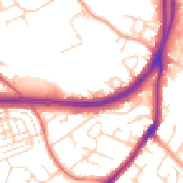
Daytime· 07:00 – 23:00
54.3dB

Night-time· 23:00 – 07:00
46.2dB