33 Severn Way, Watford, WD25 0DJ
About 33 Severn Way
33 Severn Way is a three-bedroom mid-terrace house in Watford (WD25 0DJ). It has a recorded floor area of 96 m² (around 1033 sq ft), construction records dating it to 1967-1975 and council tax band D. The latest certificate (October 2013) shows a D (score 64), on the cusp of jumping into the C band. The recommended improvements would lift it to B (score 84), a 2-band jump. The latest certificate is from October 2013, so improvements made since then won't be reflected. Records show the property has been extended at some point in its history.
At 96 m² it's 21.5% larger than the typical home in the postcode (79 m² median across 7 EPCs). Last sold in March 2014, so it's been off the market for around 12 years. Across 2005–2014, sale prices on this property compounded at 6% per year. Today's modelled estimate of £434,000 is 40% above the 2014 sale price.
What this property has
Inside
- Bedrooms3
- Dining roomYes
- Utility roomYes
- CloakroomYes
Outside
- GarageYes
Building
- Previously extendedYes
Everything you need to know about 33 Severn Way
The true value, the hidden risks and the full sale history, in one report.
30-day money-back guarantee

The data behind every report


Energy performance
Recommended upgrades on file would lift this property by multiple EPC bands.
EPC Expired
This certificate is over 10 years old and is no longer valid.Expired 17 Oct 2023
EPC Rating
Planning history
33 Severn Way has no planning applications on record.
Notable planning nearby
2applications of note in the surrounding area
Sales history & valuation
33 Severn Way valuation sits well clear of the typical sold price in this postcode.
£434,000
Modelled from EPC, postcode comparables and a sale-price growth of 6.0% per year over 8 years.
£310,000
Growth on file: 6.0% per year over 8 years.
Sales timeline
4 March 2014Most recent
£310,000
+61.0%over 8 years21 December 2005
£192,500
Median price across the last 5 sales in WD25 0DJ: £287,000 (2025–2022).
Versus other Severn Way homes
33 Severn Way is notably below the street on price per m².
Price per m²
£3,229
Street avg £4,949
Floor Area
96 m²
Street avg 89 m²
Habitable Rooms
4 rooms
Street avg 5 rooms
CO₂ Emissions
3.8 t/year
Street avg 3.8 t/year
Everything you need to know about 33 Severn Way
The true value, the hidden risks and the full sale history, in one report.
30-day money-back guarantee
The data behind every report
Similar properties nearby
1 Derwent Close
WD25 0NQ
1 Austin Villas, Woodside Road
WD25 0GD
1 Bramble Close
WD25 0HF
1 All Saints Crescent
WD25 0LU
1 Cedar Wood Drive
WD25 0RR
1 Alder Walk
WD25 0RT
1 Coopers Mews
WD25 0JD
1 Aspen Park Drive
WD25 0RS
The neighbourhood at a glance
Rail-style transport is unusually close for this postcode.
Crime
4/mo
Steady year-on-year across the wider district.
Nearest stop
0.1 km
St Albans Road — bus stop.
Closest school
0.7 km
The Grove Academy. 24 schools nearby.
Go deeper on the local area
The full report breaks down crime, transport links, schools and air quality in depth.
Road noise across the postcode
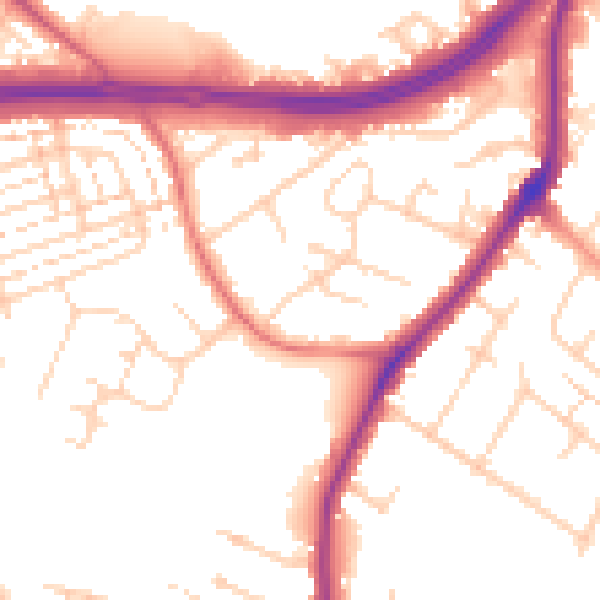
Daytime· 07:00 – 23:00
53.3dB

Night-time· 23:00 – 07:00
45.1dB