22 Priory Drive, Bexley, London, SE2 0PP
About 22 Priory Drive
22 Priory Drive is a three-bedroom detached house in Bexley, London, London (SE2 0PP). It has a recorded floor area of 117 m² (around 1259 sq ft), construction records dating it to 1930-1949 and council tax band E. The latest certificate (May 2016) shows an E (score 44), well below the UK norm with real room to improve. The recommended improvements would lift it to C (score 74), a 2-band jump. The latest certificate is from May 2016, so improvements made since then won't be reflected.
At 117 m² it's 17% larger than the typical home in the postcode (100 m² median across 17 EPCs). Today's modelled estimate of £642,000 is 36.6% above the 2016 sale price. On a £-per-square-foot basis, the last sale (£373/sq ft) was about 37.7% above the typical sold price in the postcode. On the market in August 2016 and unlisted since — roughly 10 years.
What this property has
Inside
- Bedrooms3
- Bathrooms2
Everything you need to know about 22 Priory Drive
The true value, the hidden risks and the full sale history, in one report.
Pick your report · every report is £14.99
One time fee only - money back guarantee

The data behind every report


Energy performance
22 Priory Drive's carbon output runs well above what efficient homes in the postcode produce.
EPC Expired
This certificate is over 10 years old and is no longer valid.Expired 20 May 2026
EPC Rating
Get a survey for this property
Level 3 Building Survey
Because the property has solid (non-cavity) walls, we believe a Level 3 building survey should be considered.
From £1,155 · Includes VAT
Planning history
22 Priory Drive has no planning applications on record.
But the area is active
44 notable applications nearby — larger schemes and conversions that could reshape the street. The report maps them all.
Sales history & valuation
22 Priory Drive valuation sits well clear of the typical sold price in this postcode.
£642,000
Modelled from EPC, postcode comparables.
£470,000
Recorded with HM Land Registry.
Sales timeline
16 August 2016Most recent
£470,000
Median price across the last 5 sales in SE2 0PP: £600,000 (2023–2021).
Nearby sales in SE2 0PP
12 Priory Drive, Bexley, London, SE2 0PP
Sold Aug 2023
£600,0001 Priory Drive, Bexley, London, SE2 0PP
Sold Jul 2023
£475,00015 Priory Drive, Bexley, London, SE2 0PP
Sold Apr 2023
£750,00021 Priory Drive, Bexley, London, SE2 0PP
Sold Mar 2022
£467,50017 Priory Drive, Bexley, London, SE2 0PP
Sold Sept 2021
£675,000
Versus other Priory Drive homes
On epc rating, 22 Priory Drive runs well behind the street norm.
Price per m²
£4,017
Street avg £3,871
Floor Area
117 m²
Street avg 113 m²
Habitable Rooms
6 rooms
Street avg 5 rooms
CO₂ Emissions
7.7 t/year
Street avg 5.0 t/year
Everything you need to know about 22 Priory Drive
The true value, the hidden risks and the full sale history, in one report.
Pick your report · every report is £14.99
One time fee only - money back guarantee
The data behind every report
Similar properties nearby
1 Congress Road, Greenwich
SE2 0LT
1 Glendown Road, Greenwich
SE2 0RJ
1 Harvel Crescent, Bexley
SE2 0PT
1 Cassilda Road, Greenwich
SE2 0ES
1 Greening Street, Greenwich
SE2 0LX
1 Chancelot Road, Greenwich
SE2 0NB
1 Crumpsall Street, Greenwich
SE2 0LP
1 Dianthus Close, Greenwich
SE2 0UX
The neighbourhood at a glance
Reported crime in the wider district is trending notably upward year-on-year.
Crime
7/mo
Rising year-on-year across the wider district.
Nearest stop
0.1 km
Hurst Lane — bus stop.
Closest school
0.6 km
Bedonwell Infant and Nursery School. 53 schools nearby.
Go deeper on the local area
A Local Area report breaks down crime, transport links, schools and air quality in depth.
Road noise across the postcode
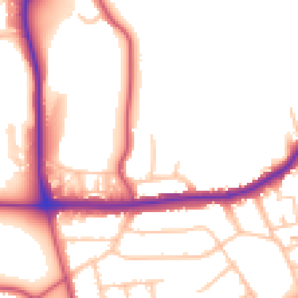
Daytime· 07:00 – 23:00
52.0dB

Night-time· 23:00 – 07:00
42.3dB