20 Priory Drive, Bexley, London, SE2 0PP
About 20 Priory Drive
20 Priory Drive is a four-bedroom property in Bexley, London, London (SE2 0PP). It has council tax band E.
Held since August 2007 — that's 19 years off the open market, well above the local norm. That sale landed at the peak of the pre-credit-crunch market, which is a useful reference point when interpreting the price. Across 2004–2007, sale prices on this property compounded at 7.4% per year. One historical planning record sits against the property in 2024.
What this property has
Inside
- Bedrooms4
Everything you need to know about 20 Priory Drive
The true value, the hidden risks and the full sale history, in one report.
Pick your report · every report is £14.99
One time fee only - money back guarantee

The data behind every report


Energy performance
No EPC on record
This property doesn't have an Energy Performance Certificate yet. An EPC is required to sell or let — and unlocks our automated valuation.
Get a survey for this property
Level 2 HomeBuyer Report
We've checked 10 risk factors against the available data for this property and believe a Level 2 HomeBuyer Report could be a suitable option for you.
Planning history
1 application on record at 20 Priory Drive, Bexley, London, SE2 0PP
- Feb 2024Demolition And RebuildFullOutcome in report
Demolition of the existing bungalow and erection of two semi-detached, 3 storey dwelling houses.
- Documents
- 7 docs on file
- Reference
- 24/00676/FUL
Unlock 20 Priory Drive, Bexley, London, SE2 0PP's full planning history
You're seeing the shape of it. The report has the substance.
- Every decision — granted, refused or withdrawn
- All 1 application on this property in full, plus 44 notable nearby
- The 7 documents, officer reports & conditions
- What the pattern means for extending or converting here
One time fee only - money back guarantee
Sales history & valuation
The latest sale landed at the peak of the pre-credit-crunch market — a high-water reference point.
£375,000
Growth on file: 7.4% per year over 3 years.
Sales timeline
8 August 2007Most recent
£375,000
+27.1%over 3 years1 April 2004
£295,000
Median price across the last 5 sales in SE2 0PP: £600,000 (2023–2021).
Nearby sales in SE2 0PP
12 Priory Drive, Bexley, London, SE2 0PP
Sold Aug 2023
£600,0001 Priory Drive, Bexley, London, SE2 0PP
Sold Jul 2023
£475,00015 Priory Drive, Bexley, London, SE2 0PP
Sold Apr 2023
£750,00021 Priory Drive, Bexley, London, SE2 0PP
Sold Mar 2022
£467,50017 Priory Drive, Bexley, London, SE2 0PP
Sold Sept 2021
£675,000
Everything you need to know about 20 Priory Drive
The true value, the hidden risks and the full sale history, in one report.
Pick your report · every report is £14.99
One time fee only - money back guarantee
The data behind every report
Similar properties nearby
1 Cassilda Road, Greenwich
SE2 0ES
1 Glendown Road, Greenwich
SE2 0RJ
1 Congress Road, Greenwich
SE2 0LT
1 Harvel Crescent, Bexley
SE2 0PT
1 Greening Street, Greenwich
SE2 0LX
1 Chancelot Road, Greenwich
SE2 0NB
1 Crumpsall Street, Greenwich
SE2 0LP
1 Federation Road, Greenwich
SE2 0JT
The neighbourhood at a glance
Reported crime in the wider district is trending notably upward year-on-year.
Crime
7/mo
Rising year-on-year across the wider district.
Nearest stop
0.1 km
Hurst Lane — bus stop.
Closest school
0.6 km
Bedonwell Infant and Nursery School. 53 schools nearby.
Go deeper on the local area
A Local Area report breaks down crime, transport links, schools and air quality in depth.
Road noise across the postcode
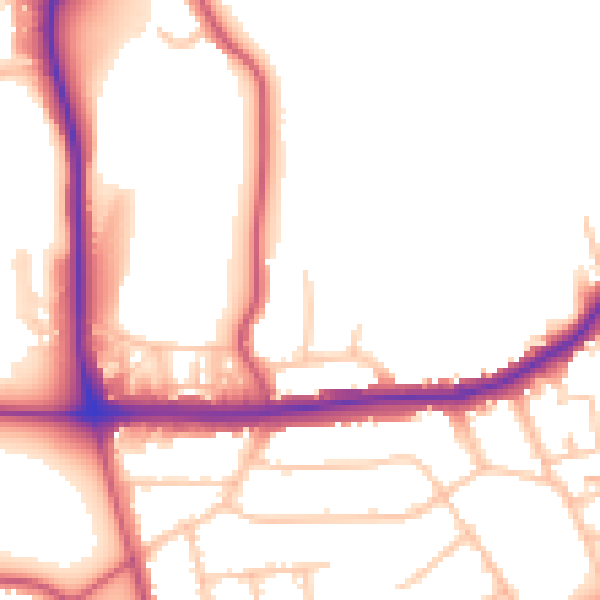
Daytime· 07:00 – 23:00
52.0dB

Night-time· 23:00 – 07:00
42.3dB