4 North Grove Rise, Leeds, LS8 2NL
About 4 North Grove Rise
4 North Grove Rise is a three-bedroom semi-detached house in Leeds (LS8 2NL). It has a recorded floor area of 101 m² (around 1087 sq ft), construction records dating it to 1967-1975 and council tax band C. The latest certificate (September 2019) shows a D (score 57), a step below the typical UK home. The recommended improvements would push it to C (score 77).
Today's modelled estimate of £351,000 is 41.5% above the 2020 sale price. On a £-per-square-foot basis, the last sale (£228/sq ft) was about 36.7% above the typical sold price in the postcode. Most recent transfer: February 2020 at £248,000.
Know exactly what you're buying at 4 North Grove Rise
Before you offer, see what the listing won't tell you, the true value, the red flags and the full history.
Valuation
against the asking price
Risks
planning & flood
Sold prices
similar homes nearby
Trends
the local market
What this property has
Inside
- Bedrooms3
Outside
- Private gardenRear
- GarageYes
- Summer houseYes
Energy performance
EPC Rating
Planning history
4 North Grove Rise has no planning applications on record.
Notable planning nearby
3applications of note in the surrounding area
Sales history & valuation
The latest sale landed in the post-pandemic price surge — useful context when reading the figure.
£351,000
Modelled from EPC, postcode comparables.
£248,000
Recorded with HM Land Registry.
Sales timeline
28 February 2020Most recent
£248,000
Median price across the last 5 sales in LS8 2NL: £300,000 (2023–2020).
Nearby sales in LS8 2NL
Everything we know about 4 North Grove Rise, in one report
What it's really worth, what could be wrong, and the planning, sales and area data in full.
- Am I paying too much?
- Is something wrong with it?
- Is the agent's story true?
- Will it hold its value?

Versus other North Grove Rise homes
4 North Grove Rise is notably below the street on epc rating.
Price per m²
£2,455
Street avg £2,264
Floor Area
101 m²
Street avg 107 m²
Habitable Rooms
5 rooms
Street avg 6 rooms
CO₂ Emissions
5.9 t/year
Street avg 4.6 t/year
Similar properties nearby
The neighbourhood at a glance
Crime
4/mo
Steady year-on-year across the wider district.
Nearest stop
0.2 km
Dib Lane — bus stop.
Closest school
0.5 km
Roundhay St John's Church of England Primary School. 35 schools nearby.
Go deeper on the local area
The full report breaks down crime, transport links, schools and air quality in depth.
Road noise across the postcode
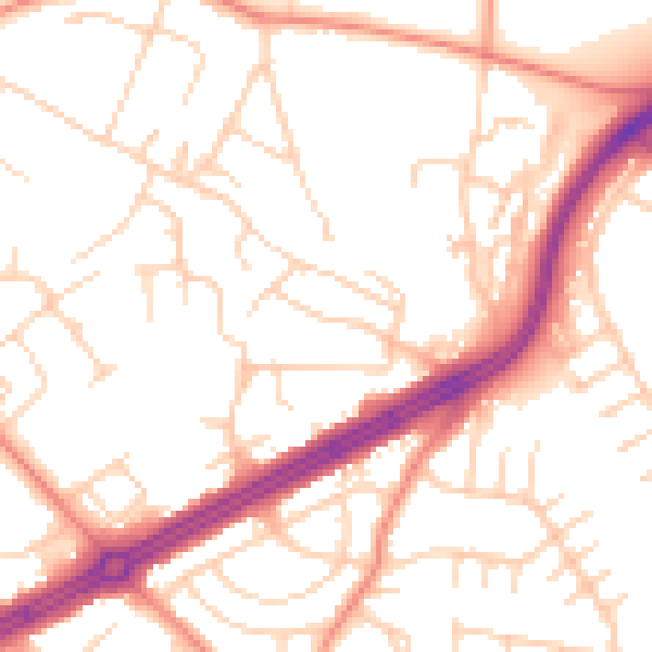
Daytime· 07:00 – 23:00
52.0dB

Night-time· 23:00 – 07:00
41.1dB