19 Bobbin Lane, Lincoln, LN2 4ZB
About 19 Bobbin Lane
19 Bobbin Lane is a four-bedroom semi-detached house in Lincoln (LN2 4ZB). It has a recorded floor area of 90 m² (around 969 sq ft), construction records dating it to 2003-2006 and council tax band C. The latest certificate (March 2019) shows a C (score 75), near the top of the C band. The rating has held steady at C across 2 certificates since December 2008. Between certificates, lighting went from Good to Very Good; while roof efficiency dropped from Very Good to Good and hot-water efficiency dropped from Very Good to Good. The recommended improvements would push it to B (score 87).
Across 2007–2019, sale prices on this property compounded at 0.7% per year. Today's modelled estimate of £253,000 is 28.1% above the 2019 sale price. On a £-per-square-foot basis, the last sale (£204/sq ft) was about 22.1% above the typical sold price in the postcode. At 90 m² it's 21.7% smaller than the typical home in the postcode (115 m² median across 63 EPCs). Last sale on file: £197,500 in October 2019.
What this property has
Inside
- Bedrooms4
- Bathrooms2
Outside
- Private gardenYes
- GarageIntegral
Building
- Heating systemElectric
Everything you need to know about 19 Bobbin Lane
The true value, the hidden risks and the full sale history, in one report.
Pick your report · every report is £14.99
One time fee only - money back guarantee

The data behind every report


Energy performance
EPC Rating
Property Improvements
Changes detected from historical EPC data
Hot water efficiency decreased
More low energy lighting installed
Get a survey for this property
Level 2 HomeBuyer Report
We've checked 10 risk factors against the available data for this property and believe a Level 2 HomeBuyer Report could be a suitable option for you.
From £545 · Includes VAT
Planning history
19 Bobbin Lane has no planning applications on record.
But the area is active
6 notable applications nearby — larger schemes and conversions that could reshape the street. The report maps them all.
Sales history & valuation
19 Bobbin Lane's sale-price growth has lagged the wider UK trajectory across its history on file.
£253,000
Modelled from EPC, postcode comparables and a sale-price growth of 0.7% per year over 13 years.
£197,500
Growth on file: 0.7% per year over 13 years.
Sales timeline
20 October 2019Most recent
£197,500
+9.7%over 12 years26 March 2007
£179,995
Median price across the last 5 sales in LN2 4ZB: £298,000 (2025–2024).
Versus other Bobbin Lane homes
EPC Rating for 19 Bobbin Lane lags the street by a wide margin.
Price per m²
£2,194
Street avg £1,952
Floor Area
90 m²
Street avg 116 m²
Habitable Rooms
6 rooms
Street avg 6 rooms
CO₂ Emissions
2.6 t/year
Street avg 2.7 t/year
Everything you need to know about 19 Bobbin Lane
The true value, the hidden risks and the full sale history, in one report.
Pick your report · every report is £14.99
One time fee only - money back guarantee
The data behind every report
Similar properties nearby
The neighbourhood at a glance
Crime
3/mo
Steady year-on-year across the wider district.
Nearest stop
0.1 km
Stockings Way — bus stop.
Closest school
0.2 km
Lincoln Carlton Academy. 15 schools nearby.
Go deeper on the local area
A Local Area report breaks down crime, transport links, schools and air quality in depth.
Road noise across the postcode
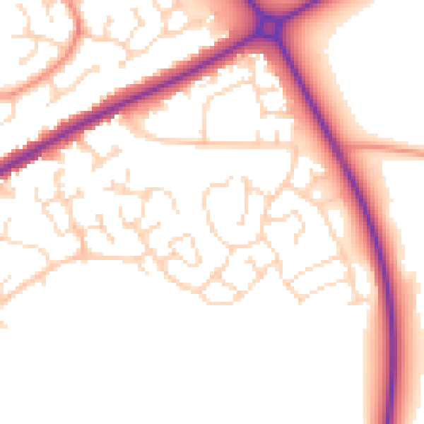
Daytime· 07:00 – 23:00
51.6dB

Night-time· 23:00 – 07:00
42.0dB