29 Bourton Avenue, Patchway, Bristol, BS34 6EB
About 29 Bourton Avenue
29 Bourton Avenue is a four-bedroom semi-detached house in Patchway, Bristol, Bristol (BS34 6EB). It has a recorded floor area of 108 m² (around 1163 sq ft), construction records dating it to 1950-1966 and council tax band D. The latest certificate (December 2016) shows a C (score 72). The recommended improvements would push it to B (score 86).
Today's modelled estimate of £465,000 sits 59.2% above the 2017 sale of £292,000. On a £-per-square-foot basis, the last sale (£251/sq ft) was about 21.9% below the postcode norm. At 108 m² it's 27.1% larger than the typical home in the postcode (85 m² median across 11 EPCs). Its energy rating outperforms most of the postcode (better than 82% of similar EPCs). Last changed hands 9 years ago, in March 2017.
What this property has
Inside
- Bedrooms4
- Bathrooms2
Everything you need to know about 29 Bourton Avenue
The true value, the hidden risks and the full sale history, in one report.
Pick your report · every report is £14.99
One time fee only - money back guarantee

The data behind every report


Energy performance
EPC Rating
Get a survey for this property
Level 2 HomeBuyer Report
We've checked 10 risk factors against the available data for this property and believe a Level 2 HomeBuyer Report could be a suitable option for you.
From £695 · Includes VAT
Planning history
29 Bourton Avenue has no planning applications on record.
But the area is active
5 notable applications nearby — larger schemes and conversions that could reshape the street. The report maps them all.
Sales history & valuation
29 Bourton Avenue valuation sits well clear of the typical sold price in this postcode.
£465,000
Modelled from EPC, postcode comparables.
£292,000
Recorded with HM Land Registry.
Sales timeline
17 March 2017Most recent
£292,000
Median price across the last 5 sales in BS34 6EB: £288,000 (2024–2018).
Nearby sales in BS34 6EB
53 Bourton Avenue, Patchway, Bristol, BS34 6EB
Sold Apr 2024
£342,00031 Bourton Avenue, Patchway, Bristol, BS34 6EB
Sold Jan 2022
£380,00047 Bourton Avenue, Patchway, Bristol, BS34 6EB
Sold Jun 2021
£285,0001 Bourton Avenue, Patchway, Bristol, BS34 6EB
Sold Nov 2019
£288,00011 Bourton Avenue, Patchway, Bristol, BS34 6EB
Sold May 2018
£280,000
Versus other Bourton Avenue homes
EPC Rating for 29 Bourton Avenue runs comfortably ahead of the street norm.
Price per m²
£2,704
Street avg £3,265
Floor Area
108 m²
Street avg 92 m²
Habitable Rooms
6 rooms
Street avg 5 rooms
CO₂ Emissions
3.2 t/year
Street avg 4.4 t/year
Everything you need to know about 29 Bourton Avenue
The true value, the hidden risks and the full sale history, in one report.
Pick your report · every report is £14.99
One time fee only - money back guarantee
The data behind every report
Similar properties nearby
1 Clanberris Court, Redfield Road, Patchway
BS34 6PJ
1 Brookfield Road, Patchway
BS34 6NF
1 Elms Grove, Patchway
BS34 6NP
1 Brookcote Drive, Little Stoke
BS34 6LG
1 Cranham Drive, Patchway
BS34 6AQ
1 Bibury Avenue, Patchway
BS34 6DE
1 Bourton Avenue, Patchway
BS34 6EB
1 Brockley Close, Little Stoke
BS34 6EZ
The neighbourhood at a glance
Crime
6/mo
Steady year-on-year across the wider district.
Nearest stop
0.1 km
Bourton Avenue — bus stop.
Closest school
0.2 km
Stoke Lodge Primary School. 20 schools nearby.
Go deeper on the local area
A Local Area report breaks down crime, transport links, schools and air quality in depth.
Road noise across the postcode
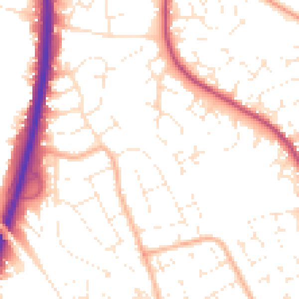
Daytime· 07:00 – 23:00
52.6dB

Night-time· 23:00 – 07:00
42.6dB