10 Colne Way, Watford, WD25 9DB
About 10 Colne Way
10 Colne Way is a four-bedroom detached house in Watford (WD25 9DB). It has a recorded floor area of 146 m² (around 1572 sq ft), construction records dating it to 1930-1949 and council tax band E. The latest certificate (April 2023) shows a D (score 67), on the cusp of jumping into the C band. The recommended improvements would lift it to B (score 82), a 2-band jump.
At 146 m² the property is well over the postcode median (102 m² across 9 EPCs), placing it in the larger end of the local stock. It changed hands recently, sold October 2025 for £740,000. Across 2010–2025, sale prices on this property compounded at 3.4% per year. On a £-per-square-foot basis, the last sale (£471/sq ft) was about 55.5% above the typical sold price in the postcode. One historical planning record sits against the property in 2010.
What this property has
Inside
- Bedrooms4
- Bathrooms3
Everything you need to know about 10 Colne Way
The true value, the hidden risks and the full sale history, in one report.
30-day money-back guarantee

The data behind every report


Energy performance
Recommended upgrades on file would lift this property by multiple EPC bands.
EPC Rating
Planning history
- Aug 2010Garage ConversionFullIn report
Conversion of garage into habitable room. Garage doors to be replaced with new UPVC window including infill wall cement rendered all to match existing.
- Documents
- 33 docs on file
- Reference
- 10/00579/FULH
What's in 10 Colne Way, Watford, WD25 9DB's planning history?
Refusals, disputes and full decisions on this property and nearby, in the report.
Sales history & valuation
10 Colne Way valuation sits well clear of the typical sold price in this postcode.
£735,000
Modelled from EPC, postcode comparables and a sale-price growth of 3.4% per year over 15 years.
£740,000
Growth on file: 3.4% per year over 15 years.
Sales timeline
16 October 2025Most recent
£740,000
+68.2%over 15 years26 May 2010
£440,000
Median price across the last 5 sales in WD25 9DB: £500,000 (2021–2015).
Versus other Colne Way homes
Years Held for 10 Colne Way lags the street by a wide margin.
Price per m²
£5,068
Street avg £4,101
Floor Area
146 m²
Street avg 110 m²
Habitable Rooms
7 rooms
Street avg 5 rooms
CO₂ Emissions
5.3 t/year
Street avg 5.9 t/year
Everything you need to know about 10 Colne Way
The true value, the hidden risks and the full sale history, in one report.
30-day money-back guarantee
The data behind every report
Similar properties nearby
The neighbourhood at a glance
Rail-style transport is unusually close for this postcode.
Crime
4/mo
Steady year-on-year across the wider district.
Nearest stop
0.1 km
Widgeon Way — bus stop.
Closest school
0.8 km
Knutsford Primary Academy. 24 schools nearby.
Go deeper on the local area
The full report breaks down crime, transport links, schools and air quality in depth.
Road noise across the postcode
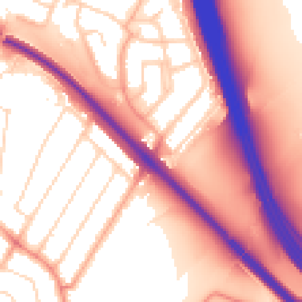
Daytime· 07:00 – 23:00
58.3dB

Night-time· 23:00 – 07:00
51.0dB