65 Harris Road, Watford, WD25 0AZ
About 65 Harris Road
65 Harris Road is a five-bedroom semi-detached house in Watford (WD25 0AZ). It has a recorded floor area of 190 m² (around 2045 sq ft), construction records dating it to 1950-1966 and council tax band D. The latest certificate (December 2024) shows a C (score 75), near the top of the C band. When first surveyed in January 2009 the rating was E, the property has climbed 2 bands since. Between certificates, roof efficiency went from Very Poor to Average, window efficiency went from Poor to Average and lighting went from Average to Very Good. The recommended improvements would push it to B (score 82).
At 190 m² the property is well over the postcode median (86 m² across 11 EPCs), placing it in the larger end of the local stock. Today's modelled estimate of £738,000 sits 58.7% above the 2016 sale of £465,000. On a £-per-square-foot basis, the last sale (£227/sq ft) was about 44.8% below the postcode norm. 5 planning records sit against the property, 1 approved, 3 refused. Past consents include an extension, a loft conversion and a porch, meaningful when judging how the property has evolved. 10 years since the last transfer (July 2016).
What this property has
Inside
- Bedrooms5
- Bathrooms2
Everything you need to know about 65 Harris Road
The true value, the hidden risks and the full sale history, in one report.
30-day money-back guarantee

The data behind every report


Energy performance
EPC Rating
Property Improvements
Changes detected from historical EPC data
Heating controls upgraded for better temperature management
Windows upgraded, improving insulation
Loft insulation installed or upgraded to 250mm+
More low energy lighting installed
Planning history
Council records show a subdivision application — the property's legal arrangement has been altered.
- Jul 2018ExtensionFullIn report
Extension: Side and rear of property
Proposed double storey side and first floor rear extension.
- Documents
- 5 docs on file
- Reference
- 18/00660/FULH
- Jul 2017Loft ConversionAmendmentIn report
Extension: Rear of property
Lawful Development Certificate for hip to gable end loft conversion with rear dormer and front roof lights. Single storey rear extension. Front Porch.
ExtensionPorch- Documents
- 9 docs on file
- Reference
- 17/00846/LDC
What's in 65 Harris Road, Watford, WD25 0AZ's planning history?
3 more on this property, plus refusals, disputes and full decisions nearby, in the report.
Sales history & valuation
65 Harris Road valuation sits well clear of the typical sold price in this postcode.
£738,000
Modelled from EPC, postcode comparables.
£465,000
Recorded with HM Land Registry.
Sales timeline
13 July 2016Most recent
£465,000
Median price across the last 5 sales in WD25 0AZ: £468,000 (2023–2017).
Versus other Harris Road homes
65 Harris Road is notably below the street on price per m².
Price per m²
£2,447
Street avg £4,735
Floor Area
190 m²
Street avg 91 m²
Habitable Rooms
7 rooms
Street avg 5 rooms
CO₂ Emissions
4.9 t/year
Street avg 3.5 t/year
Everything you need to know about 65 Harris Road
The true value, the hidden risks and the full sale history, in one report.
30-day money-back guarantee
The data behind every report
Similar properties nearby
1 Elderberry Way
WD25 0RW
1 Coles Farm, Chequers Lane
WD25 0GL
1 Cypress Walk
WD25 0RY
1 Ash Close
WD25 0RU
1 All Saints Crescent
WD25 0LU
1 Ennerdale Drive
WD25 0NG
1 Coopers Mews
WD25 0JD
1 Bramble Close
WD25 0HF
The neighbourhood at a glance
Crime
4/mo
Steady year-on-year across the wider district.
Nearest stop
0.1 km
Harris Road — bus stop.
Closest school
0.3 km
Kingsway Junior School. 28 schools nearby.
Go deeper on the local area
The full report breaks down crime, transport links, schools and air quality in depth.
Road noise across the postcode
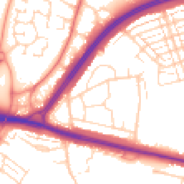
Daytime· 07:00 – 23:00
54.4dB

Night-time· 23:00 – 07:00
45.2dB