11 Fern Close, Birchwood, Warrington, WA3 7NU
About 11 Fern Close
11 Fern Close is a three-bedroom end-of-terrace house in Birchwood, Warrington, Warrington (WA3 7NU). It has a recorded floor area of 88 m² (around 947 sq ft), construction records dating it to 1983-1990 and council tax band A. The latest certificate (September 2018) shows a D (score 66), on the cusp of jumping into the C band. The recommended improvements would lift it to B (score 82), a 2-band jump. The home occupies a cul-de-sac position.
Across 2002–2019, sale prices on this property compounded at 5.4% per year. Today's modelled estimate of £190,000 sits 55.7% above the 2019 sale of £122,000. On a £-per-square-foot basis, the last sale (£129/sq ft) was about 33.3% above the typical sold price in the postcode. Sold March 2019 for £122,000.
What this property has
Inside
- Bedrooms3
- Bathrooms1
- CloakroomYes
Outside
- Private gardenYes
- Cul-de-sacYes
Everything you need to know about 11 Fern Close
The true value, the hidden risks and the full sale history, in one report.
Pick your report · every report is £14.99
One time fee only - money back guarantee

The data behind every report


Energy performance
Recommended upgrades on file would lift this property by multiple EPC bands.
EPC Rating
Get a survey for this property
Level 2 HomeBuyer Report
We've checked 10 risk factors against the available data for this property and believe a Level 2 HomeBuyer Report could be a suitable option for you.
From £495 · Includes VAT
Planning history
11 Fern Close has no planning applications on record.
A planning report still maps activity across the surrounding area and reads this property's extension & conversion potential.
Sales history & valuation
11 Fern Close has more than doubled in price since the earliest registered sale in 2002.
£190,000
Modelled from EPC, postcode comparables and a sale-price growth of 5.4% per year over 17 years.
£122,000
Growth on file: 5.4% per year over 17 years.
Sales timeline
20 March 2019Most recent
£122,000
+139.2%over 16 years11 July 2002
£51,000
Median price across the last 5 sales in WA3 7NU: £123,000 (2024–2017).
Nearby sales in WA3 7NU
34 Fern Close, Birchwood, Warrington, WA3 7NU
Sold Jan 2024
£167,00030 Fern Close, Birchwood, Warrington, WA3 7NU
Sold Nov 2020
£140,00023 Fern Close, Birchwood, Warrington, WA3 7NU
Sold Dec 2017
£123,0001 Fern Close, Birchwood, Warrington, WA3 7NU
Sold Dec 2017
£118,00022 Fern Close, Birchwood, Warrington, WA3 7NU
Sold Jul 2017
£118,000
Versus other Fern Close homes
On years held, 11 Fern Close runs well behind the street norm.
Price per m²
£1,386
Street avg £1,190
Floor Area
88 m²
Street avg 77 m²
Habitable Rooms
5 rooms
Street avg 4 rooms
CO₂ Emissions
3.6 t/year
Street avg 3.0 t/year
Everything you need to know about 11 Fern Close
The true value, the hidden risks and the full sale history, in one report.
Pick your report · every report is £14.99
One time fee only - money back guarantee
The data behind every report
Similar properties nearby
1 Fern Close, Birchwood
WA3 7NU
1 Havisham Close, Birchwood
WA3 7NB
1 Gerrard Road, Croft
WA3 7HW
1 Deacons Close, Croft
WA3 7EN
1 Eaves Brow Road, Croft
WA3 7LE
1 Gosling Road, Croft
WA3 7LN
1 Dunscar Close, Birchwood
WA3 7LS
1 Holmes Court, Birchwood
WA3 7NH
The neighbourhood at a glance
Crime
1/mo
Steady year-on-year across the wider district.
Nearest stop
0.1 km
Heather Close — bus stop.
Closest school
0.1 km
Locking Stumps Community Primary School. 16 schools nearby.
Go deeper on the local area
A Local Area report breaks down crime, transport links, schools and air quality in depth.
Road noise across the postcode
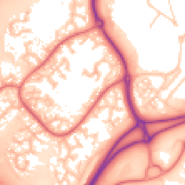
Daytime· 07:00 – 23:00
57.2dB
Night-time· 23:00 – 07:00
48.9dB