11a, Forest Road East, Nottingham, NG1 4HJ
About 11a
11a is a semi-detached house in Nottingham (NG1 4HJ). It has a recorded floor area of 68 m² (around 732 sq ft), construction records dating it to 1900-1929 and council tax band A. The latest certificate (January 2025) shows a D (score 68), on the cusp of jumping into the C band. When first surveyed in October 2010 the rating was E, the property has climbed 1 band since. Between certificates, lighting went from Average to Very Good. The recommended improvements would push it to C (score 79). At 68 m² this is the 8th smallest of 17 units on EPC record in the building, where floor areas span 45–114 m². The building's EPC ratings span D to C, with this unit at the bottom.
Across 2005–2021, sale prices on this property compounded at 7% per year. Today's modelled estimate of £314,000 is 41.4% below the 2021 sale of £536,000, below the original sale price, which typically signals condition or completion-status changes worth verifying. On a £-per-square-foot basis, the last sale (£732/sq ft) was about 305.8% above the typical sold price in the postcode. Last sale on file: £536,000 in April 2021. Across the public record there are 4 sales, relatively high churn for a single property. That sale was during the post-pandemic price surge, when transactions cleared materially above pre-2020 trend.
Everything you need to know about 11a
The true value, the hidden risks and the full sale history, in one report.
Pick your report · every report is £14.99
One time fee only - money back guarantee

The data behind every report


Energy performance
EPC Rating
Property Improvements
Changes detected from historical EPC data
Heating controls changed
More low energy lighting installed
Windows upgraded, improving insulation
More low energy lighting installed
Heating controls upgraded for better temperature management
Get a survey for this property
Level 3 Building Survey
Because the property was built before 1919 and has solid (non-cavity) walls, we believe a Level 3 building survey should be considered.
From £955 · Includes VAT
Planning history
11a has no planning applications on record.
But the area is active
16 notable applications nearby — larger schemes and conversions that could reshape the street. The report maps them all.
Sales history & valuation
Latest sale on 11a was the highest on Land Registry record across the postcode.
£314,000
Modelled from EPC, postcode comparables and a sale-price growth of 7.0% per year over 16 years.
£536,000
Growth on file: 7.0% per year over 16 years.
Sales timeline
18 April 2021Most recent
£536,000
+57.6%over 5 years28 March 2016
£340,000
+6.3%over 4 years28 July 2011
£320,000
+77.8%over 6 years2 March 2005
£180,000
Median price across the last 5 sales in NG1 4HJ: £150,000 (2021–2010).
Nearby sales in NG1 4HJ
23 Forest Road East, Nottingham, NG1 4HJ
Sold Feb 2021
£310,000Flat 2, 15 Forest Road East, Nottingham, NG1 4HJ
Sold Mar 2018
£150,00013 Forest Road East, Nottingham, NG1 4HJ
Sold Mar 2016
£148,0009a, Forest Road East, Nottingham, NG1 4HJ
Sold Aug 2014
£245,0003a, Flat 3, Forest Road East, Nottingham, NG1 4HJ
Sold Mar 2010
£40,000
Versus other Forest Road East homes
11a outperforms the street on price per m² by a wide margin.
Price per m²
£7,882
Street avg £2,308
Floor Area
68 m²
Street avg 63 m²
Habitable Rooms
4 rooms
Street avg 3 rooms
CO₂ Emissions
2.8 t/year
Street avg 2.8 t/year
Everything you need to know about 11a
The true value, the hidden risks and the full sale history, in one report.
Pick your report · every report is £14.99
One time fee only - money back guarantee
The data behind every report
Similar properties nearby
The neighbourhood at a glance
Rail-style transport is unusually close for this postcode.
Crime
39/mo
Rising year-on-year across the wider district.
Nearest stop
0.1 km
Forest Road — bus stop.
Closest school
0.6 km
Bluecoat Trent Academy. 43 schools nearby.
Go deeper on the local area
A Local Area report breaks down crime, transport links, schools and air quality in depth.
Road noise across the postcode
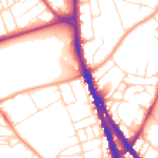
Daytime· 07:00 – 23:00
53.6dB
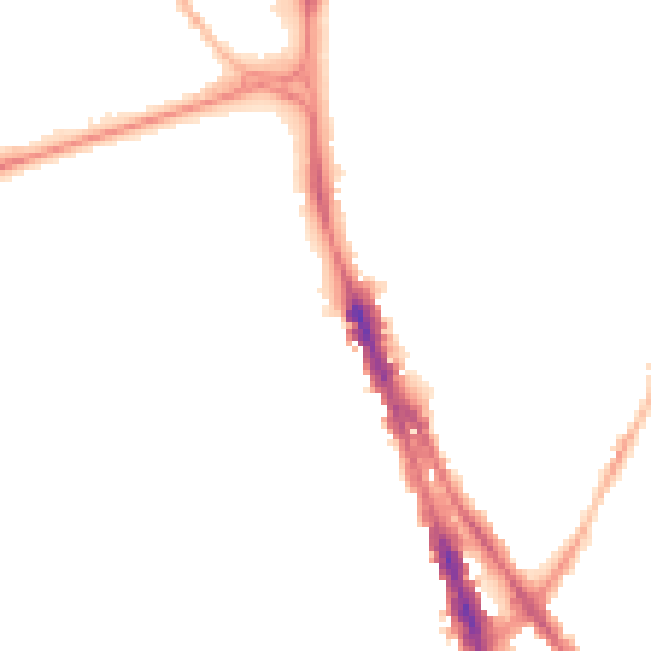
Night-time· 23:00 – 07:00
43.4dB