52 St Edwards Drive, Sudbrooke, Lincoln, LN2 2QR
About 52 St Edwards Drive
52 St Edwards Drive is a detached house in Sudbrooke, Lincoln, Lincoln (LN2 2QR). It has a recorded floor area of 168 m² (around 1808 sq ft), construction records dating it to 1967-1975 and council tax band E. The latest certificate (March 2021) shows a D (score 60), on the cusp of jumping into the C band. The recommended improvements would push it to C (score 80).
At 168 m² the property is well over the postcode median (115 m² across 33 EPCs), placing it in the larger end of the local stock. Across 2000–2024, sale prices on this property compounded at 5.6% per year. On a £-per-square-foot basis, the last sale (£241/sq ft) was about 29% above the typical sold price in the postcode. Last sale on file: £435,000 in August 2024.
Everything you need to know about 52 St Edwards Drive
The true value, the hidden risks and the full sale history, in one report.
Pick your report · every report is £14.99
One time fee only - money back guarantee

The data behind every report


Energy performance
52 St Edwards Drive's carbon output runs well above what efficient homes in the postcode produce.
EPC Rating
Get a survey for this property
Level 3 Building Survey
Because the property has been extended more than once, we believe a Level 3 building survey should be considered.
From £1,020 · Includes VAT
Planning history
52 St Edwards Drive has no planning applications on record.
But the area is active
3 notable applications nearby — larger schemes and conversions that could reshape the street. The report maps them all.
Sales history & valuation
Sale price has grown by over 3x since 2000.
£450,000
Modelled from EPC, postcode comparables and a sale-price growth of 5.6% per year over 24 years.
£435,000
Growth on file: 5.6% per year over 24 years.
Sales timeline
15 August 2024Most recent
£435,000
-8.4%over 2 years3 December 2021
£475,000
+313.0%over 21 years27 April 2000
£115,000
Median price across the last 5 sales in LN2 2QR: £360,000 (2024–2022).
Nearby sales in LN2 2QR
23 St Edwards Drive, Sudbrooke, Lincoln, LN2 2QR
Sold May 2024
£350,00011 St Edwards Drive, Sudbrooke, Lincoln, LN2 2QR
Sold Feb 2024
£270,00046 St Edwards Drive, Sudbrooke, Lincoln, LN2 2QR
Sold Dec 2022
£360,00033 St Edwards Drive, Sudbrooke, Lincoln, LN2 2QR
Sold Aug 2022
£360,00054 St Edwards Drive, Sudbrooke, Lincoln, LN2 2QR
Sold Jul 2022
£445,000
Versus other St Edwards Drive homes
52 St Edwards Drive is notably below the street on years held.
Price per m²
£2,589
Street avg £2,237
Floor Area
168 m²
Street avg 123 m²
Habitable Rooms
8 rooms
Street avg 5 rooms
CO₂ Emissions
8.0 t/year
Street avg 5.6 t/year
Everything you need to know about 52 St Edwards Drive
The true value, the hidden risks and the full sale history, in one report.
Pick your report · every report is £14.99
One time fee only - money back guarantee
The data behind every report
Similar properties nearby
1 Beresford Drive, Sudbrooke
LN2 2YH
1 Abbots Way, Scothern
LN2 2FA
1 Blossoms Ranch, Grange De Lings
LN2 2LY
1 Broad Dale Close, Sudbrooke
LN2 2FD
1 Beech Close, Sudbrooke
LN2 2QW
1 Ambrose Court, Nettleham
LN2 2EJ
1 Bramble Court, Nettleham
LN2 2WG
1 Arnage Court, Nettleham
LN2 2ZB
The neighbourhood at a glance
Crime
3/mo
Steady year-on-year across the wider district.
Nearest stop
0.2 km
Windsor Close — bus stop.
Closest school
1.7 km
Ellison Boulters Church of England Primary School. 4 schools nearby.
Go deeper on the local area
A Local Area report breaks down crime, transport links, schools and air quality in depth.
Road noise across the postcode
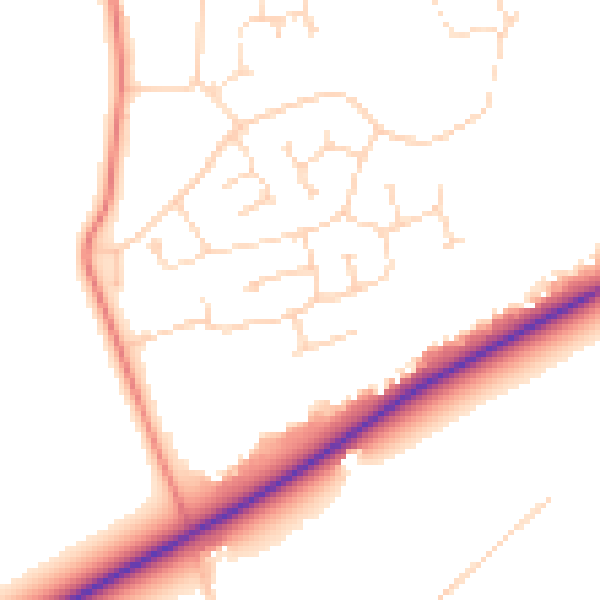
Daytime· 07:00 – 23:00
50.6dB

Night-time· 23:00 – 07:00
40.7dB