14 Hatherwood, Leatherhead, KT22 8TT
About 14 Hatherwood
14 Hatherwood is a three-bedroom detached house in Leatherhead (KT22 8TT). It has a recorded floor area of 176 m² (around 1894 sq ft), construction records dating it to 1976-1982 and council tax band F. The latest certificate (February 2025) shows a C (score 72). When first surveyed in July 2011 the rating was D, the property has climbed 1 band since. Between certificates, wall efficiency went from Average to Good, window efficiency went from Average to Good and lighting went from Very Poor to Very Good; while roof efficiency dropped from Good to Poor. The recommended improvements would push it to B (score 81). Other recorded features include a conservatory.
At 176 m² the property is well over the postcode median (113 m² across 26 EPCs), placing it in the larger end of the local stock. Across 1999–2011, sale prices on this property compounded at 6.6% per year. Today's modelled estimate of £896,000 sits 107.9% above the 2011 sale of £431,000. On a £-per-square-foot basis, the last sale (£228/sq ft) was about 20.8% below the postcode norm. 3 planning records sit against the property, 2 approved, 1 refused. Past consents include a loft conversion, an extension and partial demolition, meaningful when judging how the property has evolved. On the market in November 2011 and unlisted since — roughly 15 years.
Know exactly what you're buying at 14 Hatherwood
Before you offer, see what the listing won't tell you, the true value, the red flags and the full history.
Already flagged here
Valuation
against the asking price
Risks
planning & flood
Sold prices
similar homes nearby
Trends
the local market
What this property has
Inside
- Bedrooms3
- ConservatoryYes
Outside
- Private gardenSouth-facing
Energy performance
EPC Rating
Property Improvements
Changes detected from historical EPC data
Window efficiency improved
Wall insulation upgraded
More low energy lighting installed
Planning history
Planning history includes recorded demolition works, indicating a major rebuild phase at this address.
- Aug 2020Loft ConversionAmendmentIn report
Certificate of Lawfulness for an existing use in respect of a conversion of loft space with 1 No. rear dormer, with 2 No. front roof lights and 3 No. rear windows.
Retrospective- Documents
- 8 docs on file
- Reference
- MO/2020/0853
- May 2020Loft ConversionFullIn report
Loft conversion with dormer window.
- Documents
- 8 docs on file
- Reference
- MO/2020/0475
We flagged 1 thing worth checking at 14 Hatherwood
Independent checks surfaced things a buyer would want to understand before offering. The report explains each one in full, with the underlying data and what to ask.
- Larger development activity nearby
30-day money-back guarantee
Sales history & valuation
14 Hatherwood has more than doubled in price since the earliest registered sale in 1999.
£896,000
Modelled from EPC, postcode comparables and a sale-price growth of 6.6% per year over 13 years.
£431,000
Growth on file: 6.6% per year over 13 years.
Sales timeline
11 November 2011Most recent
£431,000
+46.1%over 9 years5 August 2002
£295,000
+56.1%over 3 years7 January 1999
£189,000
Median price across the last 5 sales in KT22 8TT: £739,000 (2025–2023).
Nearby sales in KT22 8TT
Everything we know about 14 Hatherwood, in one report
What it's really worth, what could be wrong, and the planning, sales and area data in full.
What we flagged
- Larger development activity nearby

Versus other Hatherwood homes
On floor area, 14 Hatherwood stands well clear of the street.
Price per m²
£2,449
Street avg £4,191
Floor Area
176 m²
Street avg 130 m²
Habitable Rooms
7 rooms
Street avg 7 rooms
CO₂ Emissions
5.0 t/year
Street avg 4.4 t/year
Similar properties nearby
1 Highwoods
KT22 8RR
1 Heymede
KT22 8PG
1 Byron Place
KT22 8AX
1 Daymerslea Ridge
KT22 8TF
1 Clinton Road
KT22 8NU
1 Highlands Mews, Highlands Road
KT22 8DA
1 Brancaster Grove, Ermyn Way
KT22 8FE
1 Highlands Close
KT22 8NG
The neighbourhood at a glance
Crime
3/mo
Steady year-on-year across the wider district.
Nearest stop
0.2 km
Grange Road — bus stop.
Closest school
0.5 km
West Ashtead Primary Academy. 8 schools nearby.
Go deeper on the local area
The full report breaks down crime, transport links, schools and air quality in depth.
Road noise across the postcode
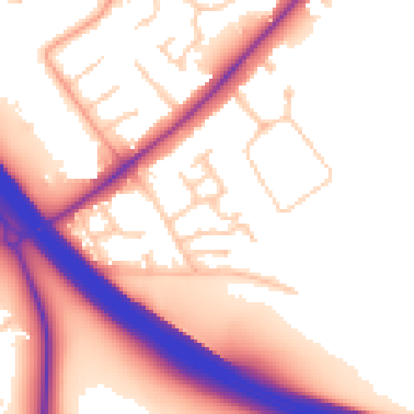
Daytime· 07:00 – 23:00
55.8dB

Night-time· 23:00 – 07:00
49.1dB