37 Beech Road, Watford, WD24 6NZ
About 37 Beech Road
37 Beech Road is a three-bedroom detached house in Watford (WD24 6NZ). It has a recorded floor area of 70 m² (around 753 sq ft), construction records dating it to 1996-2002 and council tax band E. The latest certificate (January 2012) shows a D (score 63), on the cusp of jumping into the C band. The recommended improvements would push it to C (score 69). The latest certificate is from January 2012, so improvements made since then won't be reflected.
Today's modelled estimate of £483,000 is 25.1% above the 2018 sale price. On a £-per-square-foot basis, the last sale (£513/sq ft) was about 229.7% above the typical sold price in the postcode. Last sold in January 2018, so it's been off the market for around 8 years. At 70 m² it's 28.7% smaller than the typical home in the postcode (98 m² median across 18 EPCs).
What this property has
Inside
- Bedrooms3
- Dining roomYes
- CloakroomYes
Outside
- Private gardenYes
- ParkingOff street
Everything you need to know about 37 Beech Road
The true value, the hidden risks and the full sale history, in one report.
30-day money-back guarantee

The data behind every report


Energy performance
37 Beech Road's EPC is over a decade old — improvements since won't be reflected.
EPC Expired
This certificate is over 10 years old and is no longer valid.Expired 11 Jan 2022
EPC Rating
Planning history
37 Beech Road has no planning applications on record.
Notable planning nearby
4applications of note in the surrounding area
We flagged 1 thing worth checking at 37 Beech Road
Independent checks surfaced things a buyer would want to understand before offering. The report explains each one in full, with the underlying data and what to ask.
- Signs of HMO activity in the area
30-day money-back guarantee
Sales history & valuation
Latest sale on 37 Beech Road was the highest on Land Registry record across the postcode.
£483,000
Modelled from EPC, postcode comparables.
£386,000
Recorded with HM Land Registry.
Sales timeline
12 January 2018Most recent
£386,000
Median price across the last 5 sales in WD24 6NZ: £250,000 (2015–2010).
Versus other Beech Road homes
On price per m², 37 Beech Road stands well clear of the street.
Price per m²
£5,521
Street avg £2,181
Floor Area
70 m²
Street avg 105 m²
Habitable Rooms
4 rooms
Street avg 6 rooms
CO₂ Emissions
3.3 t/year
Street avg 5.4 t/year
Everything you need to know about 37 Beech Road
The true value, the hidden risks and the full sale history, in one report.
30-day money-back guarantee
The data behind every report
Similar properties nearby
The neighbourhood at a glance
Rail-style transport is unusually close for this postcode.
Crime
4/mo
Rising year-on-year across the wider district.
Nearest stop
0.2 km
Brett Place — bus stop.
Closest school
0.4 km
Cherry Tree Primary School. 32 schools nearby.
Go deeper on the local area
The full report breaks down crime, transport links, schools and air quality in depth.
Road noise across the postcode
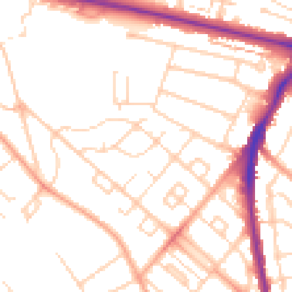
Daytime· 07:00 – 23:00
51.6dB

Night-time· 23:00 – 07:00
41.2dB