16 Pocket Nook Lane, Lowton, Warrington, WA3 1AH
About 16 Pocket Nook Lane
16 Pocket Nook Lane is a mid-terrace house in Lowton, Warrington, Warrington (WA3 1AH). It has a recorded floor area of 81 m² (around 872 sq ft), construction records dating it to 1900-1929 and council tax band A. The latest certificate (October 2020) shows a D (score 67), on the cusp of jumping into the C band. The recommended improvements would lift it to B (score 86), a 2-band jump.
Across 1999–2021, sale prices on this property compounded at 8.1% per year. Today's modelled estimate of £162,000 is 24.6% above the 2021 sale price. Most recent transfer: March 2021 at £130,000. That sale was during the post-pandemic price surge, when transactions cleared materially above pre-2020 trend.
Everything you need to know about 16 Pocket Nook Lane
The true value, the hidden risks and the full sale history, in one report.
Pick your report · every report is £14.99
One time fee only - money back guarantee

The data behind every report


Energy performance
Recommended upgrades on file would lift this property by multiple EPC bands.
EPC Rating
Get a survey for this property
Level 3 Building Survey
Because the property was built before 1919 and has been extended more than once, we believe a Level 3 building survey should be considered.
From £820 · Includes VAT
Planning history
16 Pocket Nook Lane has no planning applications on record.
A planning report still maps activity across the surrounding area and reads this property's extension & conversion potential.
Sales history & valuation
16 Pocket Nook Lane has more than quadrupled in price since its earliest registered sale in 1999.
£162,000
Modelled from EPC, postcode comparables and a sale-price growth of 8.1% per year over 21 years.
£130,000
Growth on file: 8.1% per year over 21 years.
Sales timeline
28 March 2021Most recent
£130,000
+18.2%over 5 years27 August 2015
£110,000
+340.0%over 15 years23 December 1999
£25,000
Median price across the last 5 sales in WA3 1AH: £153,500 (2023–2020).
Nearby sales in WA3 1AH
22 Pocket Nook Lane, Lowton, Warrington, WA3 1AH
Sold Sept 2023
£250,00036 Pocket Nook Lane, Lowton, Warrington, WA3 1AH
Sold Feb 2022
£260,00020 Pocket Nook Lane, Lowton, Warrington, WA3 1AH
Sold Nov 2021
£153,50010 Pocket Nook Lane, Lowton, Warrington, WA3 1AH
Sold Feb 2021
£129,99518 Pocket Nook Lane, Lowton, Warrington, WA3 1AH
Sold Jan 2020
£114,500
Versus other Pocket Nook Lane homes
16 Pocket Nook Lane is notably below the street on years held.
Price per m²
£1,605
Street avg £2,068
Floor Area
81 m²
Street avg 78 m²
Habitable Rooms
4 rooms
Street avg 4 rooms
CO₂ Emissions
3.2 t/year
Street avg 4.1 t/year
Everything you need to know about 16 Pocket Nook Lane
The true value, the hidden risks and the full sale history, in one report.
Pick your report · every report is £14.99
One time fee only - money back guarantee
The data behind every report
Similar properties nearby
1 Chapel Terrace, Lowton
WA3 1EF
1 Carr Lane, Lowton
WA3 1AF
1 Gregory Row, Lowton
WA3 1DJ
1 Kay Gardens, Lowton
WA3 1AG
1 Kane Court, Sandy Lane, Lowton
WA3 1DA
1 Bodden Street, Lowton
WA3 1DX
1 Carr Green, Lowton
WA3 1EQ
1 Heathmoor Avenue, Lowton
WA3 1HP
The neighbourhood at a glance
Crime
1/mo
Steady year-on-year across the wider district.
Nearest stop
0.2 km
Pocket Nook Lane — bus stop.
Closest school
0.3 km
Lowton St Mary's CofE (Voluntary Aided) Primary School. 12 schools nearby.
Go deeper on the local area
A Local Area report breaks down crime, transport links, schools and air quality in depth.
Road noise across the postcode
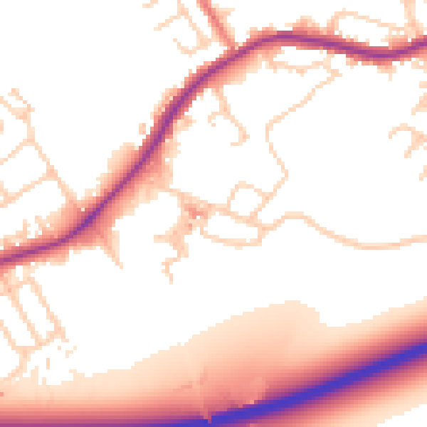
Daytime· 07:00 – 23:00
54.3dB

Night-time· 23:00 – 07:00
47.9dB