11 Broadbent Street, Brotton, Saltburn By The Sea, TS12 2TF
About 11 Broadbent Street
11 Broadbent Street is a two-bedroom mid-terrace house in Brotton, Saltburn-By-The-Sea, Saltburn By The Sea (TS12 2TF). It has a recorded floor area of 60 m² (around 646 sq ft), construction records dating it to 1900-1929 and council tax band A. The latest certificate (March 2022) shows a D (score 60), on the cusp of jumping into the C band. The rating has held steady at D across 4 certificates since January 2009. Between certificates, roof efficiency dropped from Good to Very Poor. The recommended improvements would lift it to B (score 82), a 2-band jump. Other recorded features include a loft.
Held since October 2005 — that's 21 years off the open market, well above the local norm. Across 1998–2005, sale prices on this property compounded at 24.4% per year. Today's modelled estimate of £109,000 sits 78.7% above the 2005 sale of £61,000. On a £-per-square-foot basis, the last sale (£94/sq ft) was about 53.2% above the typical sold price in the postcode.
Know exactly what you're buying at 11 Broadbent Street
Before you offer, see what the listing won't tell you, the true value, the red flags and the full history.
Already flagged here
Launch offer · save £5
Valuation
against the asking price
Risks
planning & flood
Sold prices
similar homes nearby
Trends
the local market
What this property has
Inside
- Bedrooms2
- LoftYes
Building
- Heating systemgas
Energy performance
Recommended upgrades on file would lift this property by multiple EPC bands.
EPC Rating
Property Improvements
Changes detected from historical EPC data
Wall insulation improved
More low energy lighting installed
Low energy lighting percentage decreased
Planning history
11 Broadbent Street has no planning applications on record.
Notable planning nearby
1applications of note in the surrounding area
We flagged 1 thing worth checking at 11 Broadbent Street
Independent checks surfaced things a buyer would want to understand before offering. The report explains each one in full, with the underlying data and what to ask.
- Larger development activity nearby
30-day money-back guarantee
Sales history & valuation
Price for 11 Broadbent Street has grown more than fourfold since the 1998 starting point.
£109,000
Modelled from EPC, postcode comparables and a sale-price growth of 24.4% per year over 7 years.
£61,000
Growth on file: 24.4% per year over 7 years.
Sales timeline
23 October 2005Most recent
£61,000
+408.3%over 7 years13 May 1998
£12,000
Median price across the last 5 sales in TS12 2TF: £53,000 (2021–2019).
Nearby sales in TS12 2TF
Lumpsey View, Broadbent Street, Brotton, Saltburn By The Sea, TS12 2TF
Sold Nov 2021
£145,00013 Broadbent Street, Brotton, Saltburn By The Sea, TS12 2TF
Sold Mar 2021
£44,00015 Broadbent Street, Brotton, Saltburn By The Sea, TS12 2TF
Sold Nov 2020
£63,00010 Broadbent Street, Brotton, Saltburn By The Sea, TS12 2TF
Sold Nov 2019
£34,50012 Broadbent Street, Brotton, Saltburn By The Sea, TS12 2TF
Sold Jun 2019
£53,000
Everything we know about 11 Broadbent Street, in one report
What it's really worth, what could be wrong, and the planning, sales and area data in full.
What we flagged
- Larger development activity nearby

Versus other Broadbent Street homes
11 Broadbent Street outperforms the street on years held by a wide margin.
Price per m²
£1,017
Street avg £930
Floor Area
60 m²
Street avg 77 m²
Habitable Rooms
4 rooms
Street avg 4 rooms
CO₂ Emissions
3.8 t/year
Street avg 3.9 t/year
Similar properties nearby
1 Carricks Yard, Skelton In Cleveland
TS12 2EG
1 Buckfast Road, Skelton In Cleveland
TS12 2YJ
1 Brotton Hall, Broctune Gardens, Brotton
TS12 2GF
1 Broadbent Street, Brotton
TS12 2TF
1 Ambleside, Skelton In Cleveland
TS12 2GZ
1 Burley Close, Skelton In Cleveland
TS12 2PW
1 2, Bolckow Street, Skelton In Cleveland
TS12 2AN
1 Byland Road, Skelton In Cleveland
TS12 2NJ
The neighbourhood at a glance
Reported crime in the wider district is trending notably upward year-on-year.
Crime
4/mo
Rising year-on-year across the wider district.
Nearest stop
0.1 km
Whitecliffe Centre — bus stop.
Closest school
0.5 km
Badger Hill Academy. 5 schools nearby.
Go deeper on the local area
The full report breaks down crime, transport links, schools and air quality in depth.
Road noise across the postcode
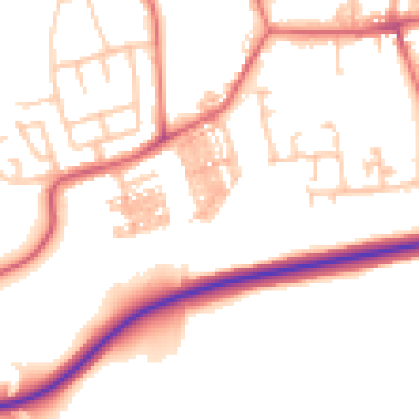
Daytime· 07:00 – 23:00
52.1dB

Night-time· 23:00 – 07:00
41.5dB