18 Alders Green Avenue, High Lane, Stockport, SK6 8EB
About 18 Alders Green Avenue
18 Alders Green Avenue is a four-bedroom property in High Lane, Stockport, Stockport (SK6 8EB). It has council tax band E. Period features are noted in the property record. Records show the property has been extended at some point in its history. The home occupies a corner plot.
One planning record on file: an extension approved in 2010. Past consents include an extension, meaningful when judging how the property has evolved. Last changed hands 8 years ago, in March 2018. Across 2009–2018, sale prices on this property compounded at 5.1% per year.
What this property has
Inside
- Bedrooms4
- Bathrooms2
- Dining roomYes
- EnsuiteYes
Outside
- Private gardenRear
- GarageYes
- Corner plotYes
Building
- Central heatingYes
- Period featuresYes
- Previously extendedYes
Everything you need to know about 18 Alders Green Avenue
The true value, the hidden risks and the full sale history, in one report.
Pick your report · every report is £14.99
One time fee only - money back guarantee

The data behind every report


Energy performance
No EPC on record
This property doesn't have an Energy Performance Certificate yet. An EPC is required to sell or let — and unlocks our automated valuation.
Get a survey for this property
Level 2 HomeBuyer Report
We've checked 10 risk factors against the available data for this property and believe a Level 2 HomeBuyer Report could be a suitable option for you.
Planning history
18 Alders Green Avenue has an approved side and rear extension on the planning record.
1 application on record at 18 Alders Green Avenue, High Lane, Stockport, SK6 8EB
- Jan 2010ExtensionFullOutcome in report
Extension: Side and rear of property
Two storey side extension and single storey rear extension
- Documents
- 8 docs on file
- Reference
- DC/043359
Unlock 18 Alders Green Avenue, High Lane, Stockport, SK6 8EB's full planning history
You're seeing the shape of it. The report has the substance.
- Every decision — granted, refused or withdrawn (1 on record)
- All 1 application on this property in full
- The 8 documents, officer reports & conditions
- What the pattern means for extending or converting here
One time fee only - money back guarantee
Sales history & valuation
£355,000
Growth on file: 5.1% per year over 9 years.
Sales timeline
9 March 2018Most recent
£355,000
+52.4%over 8 years2 September 2009
£233,000
Median price across the last 5 sales in SK6 8EB: £486,750 (2025–2021).
Nearby sales in SK6 8EB
3 Alders Green Avenue, High Lane, Stockport, SK6 8EB
Sold Jan 2025
£467,50014 Alders Green Avenue, High Lane, Stockport, SK6 8EB
Sold Feb 2023
£530,00015 Alders Green Avenue, High Lane, Stockport, SK6 8EB
Sold Apr 2022
£550,0007 Alders Green Avenue, High Lane, Stockport, SK6 8EB
Sold Apr 2022
£486,75013 Alders Green Avenue, High Lane, Stockport, SK6 8EB
Sold Jun 2021
£345,000
Everything you need to know about 18 Alders Green Avenue
The true value, the hidden risks and the full sale history, in one report.
Pick your report · every report is £14.99
One time fee only - money back guarantee
The data behind every report
Similar properties nearby
1 Dovedale Close, High Lane
SK6 8DU
1 Charnwood, High Lane
SK6 8DZ
1 Ashley Gardens, Windlehurst Road, High Lane
SK6 8AB
1 Brookside Lane, High Lane
SK6 8HL
1 Coniston Road, High Lane
SK6 8AW
1 Carr Brow, High Lane
SK6 8EX
1 Dene Way, High Lane
SK6 8EQ
1 Bowfell Drive, High Lane
SK6 8HZ
The neighbourhood at a glance
Daytime road noise here sits well below conversation level — a quiet pocket of the postcode.
Crime
1/mo
Steady year-on-year across the wider district.
Nearest stop
0.1 km
Carr Brow — bus stop.
Closest school
0.4 km
Brookside Primary School. 5 schools nearby.
Go deeper on the local area
A Local Area report breaks down crime, transport links, schools and air quality in depth.
Road noise across the postcode
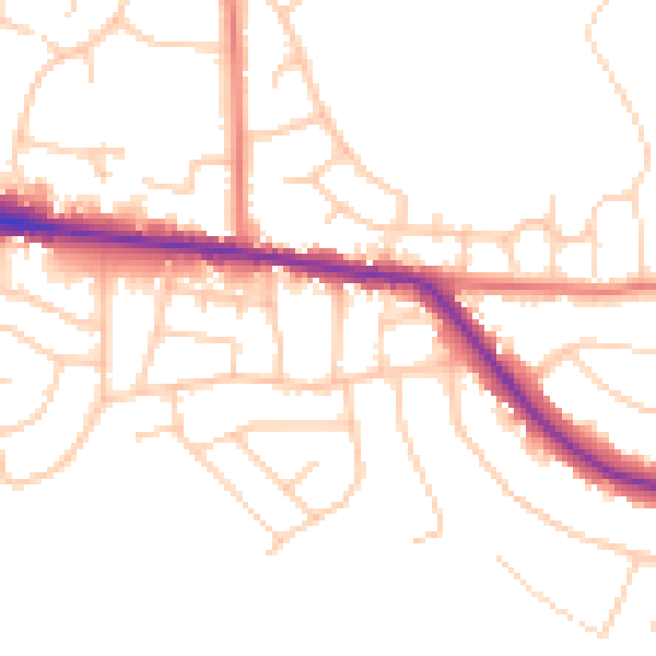
Daytime· 07:00 – 23:00
49.2dB

Night-time· 23:00 – 07:00
40.9dB