1 Coleraine Road, Greenwich, London, SE3 7PF
About 1 Coleraine Road
1 Coleraine Road is a five-bedroom end-of-terrace house in Greenwich, London, London (SE3 7PF). It has a recorded floor area of 151 m² (around 1625 sq ft), construction records dating it to 1967-1975 and council tax band E. The latest certificate (May 2013) shows a C (score 74). The recommended improvements would push it to B (score 82). The latest certificate is from May 2013, so improvements made since then won't be reflected. The home occupies a corner plot.
Untraded for 24 years, with the last transfer in August 2002. At 151 m² the property is well over the postcode median (111 m² across 50 EPCs), placing it in the larger end of the local stock. Its energy rating outperforms most of the postcode (better than 84% of similar EPCs). 5 bedrooms is on the larger side for this postcode, where 4 is the typical count. Today's modelled estimate of £972,000 sits 213.5% above the 2002 sale of £310,000. On a £-per-square-foot basis, the last sale (£191/sq ft) was about 54.5% below the postcode norm. 10 planning records sit against the property, 3 approved, 2 refused. Past consents include an extension, a porch and tree works, meaningful when judging how the property has evolved.
Know exactly what you're buying at 1 Coleraine Road
Before you offer, see what the listing won't tell you, the true value, the red flags and the full history.
Valuation
against the asking price
Risks
planning & flood
Sold prices
similar homes nearby
Trends
the local market
What this property has
Inside
- Bedrooms5
- Bathrooms2
- Dining roomYes
- EnsuiteYes
Outside
- ParkingOff street
- Corner plotYes
Energy performance
1 Coleraine Road's EPC is over a decade old — improvements since won't be reflected.
EPC Expired
This certificate is over 10 years old and is no longer valid.Expired 22 May 2023
EPC Rating
Planning history
1 Coleraine Road has been extended on multiple sides of the property across separate planning applications.
- Jan 2026Tree WorksTreesIn report
T1- Weeping willow approx 12m in height, previously pollarded - reduce by 4-5m back to previous pruning points. T2- Apple approx. 6m in height - reduce laterals growing towards the neighbours building by 2m to give clearance and height by 1m to rebalance and reshape the crown. Leaving crown dimensions of height 5m and lateral dimensions of 3m. T3-Plum approx. 9m in height- reduce in height by 4-5m to bring in-line with T2. Leaving crown dimensions of height 5m. T4-Plum approx. 7m in height - reduce in height by 2m and laterals to match. Leaving crown dimensions of height 5m and lateral spread of 5m. T5-Cherry approx. 5m in height and 8m spread - reduce laterals growing towards the road and house by 1.5m to rebalance and reshape. Leaving crown dimensions of height 5m and crown dimensions of 6.5. Crown Lift up to 2.5.m from above ground level.
- Agent
- Oxleas Tree Care
- Documents
- 5 docs on file
- Reference
- 25/4270/TC
- Jul 2020Tree WorksTreesIn report
1 x Pear, plum and Apple - 30% reduction to improve light and retain trees in good form
- Agent
- Oxleas Tree Care
- Documents
- 3 docs on file
- Reference
- 20/2127/TC
What's in 1 Coleraine Road, Greenwich, London, SE3 7PF's planning history?
8 more on this property, plus refusals, disputes and full decisions nearby, in the report.
Sales history & valuation
1 Coleraine Road's estimated value is more than triple its earliest registered sale price (2002).
£972,000
Modelled from EPC, postcode comparables.
£310,000
Recorded with HM Land Registry.
Sales timeline
29 August 2002Most recent
£310,000
Median price across the last 5 sales in SE3 7PF: £750,000 (2025–2023).
Nearby sales in SE3 7PF
1c, Coleraine Road, Greenwich, London, SE3 7PF
Sold Feb 2025
£690,0003a, Coleraine Road, Greenwich, London, SE3 7PF
Sold Jan 2025
£525,00051 Coleraine Road, Greenwich, London, SE3 7PF
Sold Dec 2024
£1,950,00053b, Coleraine Road, London, SE3 7PF
Sold Feb 2024
£750,0009 Coleraine Road, Greenwich, London, SE3 7PF
Sold Jul 2023
£1,250,000
Everything we know about 1 Coleraine Road, in one report
What it's really worth, what could be wrong, and the planning, sales and area data in full.
- Am I paying too much?
- Is something wrong with it?
- Is the agent's story true?
- Will it hold its value?

Versus other Coleraine Road homes
On price per m², 1 Coleraine Road runs well behind the street norm.
Price per m²
£2,053
Street avg £6,662
Floor Area
151 m²
Street avg 172 m²
Habitable Rooms
8 rooms
Street avg 7 rooms
CO₂ Emissions
3.8 t/year
Street avg 8.8 t/year
Similar properties nearby
1 Gregor Mews, Langton Way, Greenwich
SE3 7JX
1 Humber Road, Greenwich
SE3 7LT
1 Mary Lawrenson Place, Greenwich
SE3 7AY
1 Foyle Road, Greenwich
SE3 7RQ
1 Lambourne Place, Greenwich
SE3 7BH
1 Peachum Road, Greenwich
SE3 7PJ
1 Pinelands Close, St Johns Park, Greenwich
SE3 7TF
1 Belvedere Mews, Greenwich
SE3 7DF
The neighbourhood at a glance
Rail-style transport is unusually close for this postcode.
Crime
10/mo
Rising year-on-year across the wider district.
Nearest stop
0.4 km
Westcombe Park Rail Station — railway station.
Closest school
0.3 km
Halstow Primary School. 53 schools nearby.
Go deeper on the local area
The full report breaks down crime, transport links, schools and air quality in depth.
Road noise across the postcode
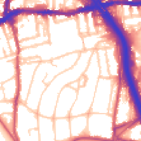
Daytime· 07:00 – 23:00
56.2dB
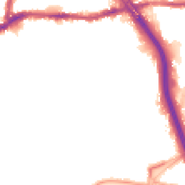
Night-time· 23:00 – 07:00
46.4dB