1 Berry Lane, Lambeth, London, SE21 8AR
About 1 Berry Lane
1 Berry Lane is an end-of-terrace house in Lambeth, London, London (SE21 8AR). It has a recorded floor area of 61 m² (around 657 sq ft), construction records dating it to 1976-1982 and council tax band C. At 61 m² this is the 14th smallest of 24 units on EPC record in the building, where floor areas span 40–84 m². The building's EPC ratings span E to C, with this unit at the top. The latest certificate (April 2023) shows a C (score 73).
At 61 m² it's 29.8% larger than the typical home in the postcode (47 m² median across 23 EPCs).
Everything you need to know about 1 Berry Lane
The true value, the hidden risks and the full sale history, in one report.
Pick your report · every report is £14.99
One time fee only - money back guarantee

The data behind every report


Energy performance
EPC Rating
Get a survey for this property
Level 2 HomeBuyer Report
We've checked 10 risk factors against the available data for this property and believe a Level 2 HomeBuyer Report could be a suitable option for you.
From £595 · Includes VAT
Planning history
1 Berry Lane has no planning applications on record.
But the area is active
1 notable application nearby — larger schemes and conversions that could reshape the street. The report maps them all.
Sales history & valuation
1 Berry Lane has no Land Registry sales on file, suggesting it has stayed in the same hands since registration began.
£349,000
Modelled from EPC, postcode comparables.
No sales recorded with HM Land Registry
That can mean the property has never traded since the registry began publishing in 1995, was a new build that hasn't been registered yet, or is held in the same hands long-term.
Median price across the last 5 sales in SE21 8AR: £325,000 (2024–2016).
Nearby sales in SE21 8AR
15 Berry Lane, Lambeth, London, SE21 8AR
Sold Jun 2024
£325,00028 Berry Lane, Lambeth, London, SE21 8AR
Sold Sept 2023
£600,0006 Berry Lane, Lambeth, London, SE21 8AR
Sold Jun 2021
£280,00017 Berry Lane, Lambeth, London, SE21 8AR
Sold Dec 2016
£360,00025 Berry Lane, Lambeth, London, SE21 8AR
Sold Nov 2009
£248,000
Versus other Berry Lane homes
1 Berry Lane outperforms the street on habitable rooms by a wide margin.
EPC Rating
73 (C)
Street avg 72 (C)
Floor Area
61 m²
Street avg 55 m²
CO₂ Emissions
1.9 t/year
Street avg 1.9 t/year
Habitable Rooms
4 rooms
Street avg 3 rooms
Everything you need to know about 1 Berry Lane
The true value, the hidden risks and the full sale history, in one report.
Pick your report · every report is £14.99
One time fee only - money back guarantee
The data behind every report
Similar properties nearby
1 Dalmore Road, Lambeth
SE21 8HD
1 Glazebrook Close, Southwark
SE21 8RP
1 Damascene Walk, Lambeth
SE21 8HJ
1 Leonora Tyson Mews, Lambeth
SE21 8GA
1 Elmworth Grove, Lambeth
SE21 8RA
1 Lairdale Close, Lambeth
SE21 8NA
1 Kennoldes, Croxted Road, Southwark
SE21 8SS
1 Bowen Drive, Southwark
SE21 8NS
The neighbourhood at a glance
Rail-style transport is unusually close for this postcode.
Crime
6/mo
Rising year-on-year across the wider district.
Nearest stop
0.1 km
Alleyn Road — bus stop.
Closest school
0.3 km
Kingswood Primary School. 59 schools nearby.
Go deeper on the local area
A Local Area report breaks down crime, transport links, schools and air quality in depth.
Road noise across the postcode
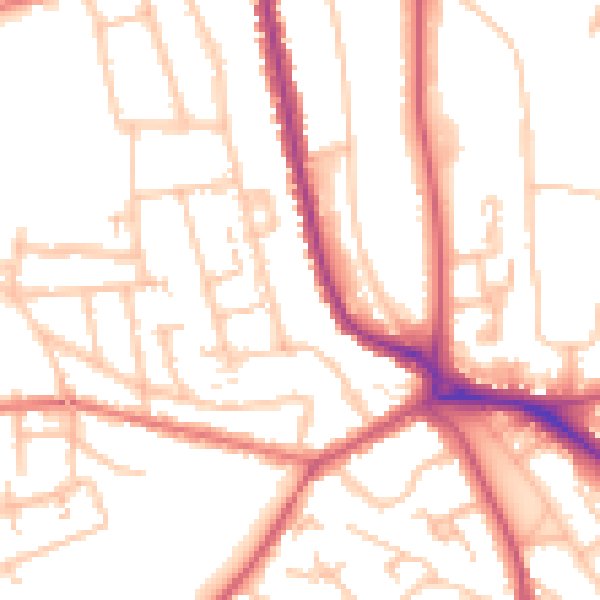
Daytime· 07:00 – 23:00
52.0dB

Night-time· 23:00 – 07:00
41.2dB