54 Waterbeach Road, Dagenham, RM9 4AA
About 54 Waterbeach Road
54 Waterbeach Road is a three-bedroom semi-detached house in Dagenham (RM9 4AA). It has a recorded floor area of 81 m² (around 872 sq ft), construction records dating it to 1950-1966 and council tax band C. Other recorded features include outbuildings. The latest certificate (May 2022) shows a C (score 71). The recommended improvements would push it to B (score 85).
Today's modelled estimate of £446,000 sits 126.4% above the 2012 sale of £197,000. On a £-per-square-foot basis, the last sale (£226/sq ft) was about 35.1% below the postcode norm. Its energy rating outperforms most of the postcode (better than 82% of similar EPCs). Last changed hands 13 years ago, in December 2012.
Know exactly what you're buying at 54 Waterbeach Road
Before you offer, see what the listing won't tell you, the true value, the red flags and the full history.
Valuation
against the asking price
Risks
planning & flood
Sold prices
similar homes nearby
Trends
the local market
What this property has
Inside
- Bedrooms3
Outside
- DrivewayYes
- OutbuildingsYes
Energy performance
EPC Rating
Planning history
54 Waterbeach Road has no planning applications on record.
The full report still covers planning activity across the surrounding area.
Sales history & valuation
54 Waterbeach Road valuation sits well clear of the typical sold price in this postcode.
£446,000
Modelled from EPC, postcode comparables.
£197,000
Recorded with HM Land Registry.
Sales timeline
20 December 2012Most recent
£197,000
Median price across the last 5 sales in RM9 4AA: £410,000 (2023–2020).
Nearby sales in RM9 4AA
Everything we know about 54 Waterbeach Road, in one report
What it's really worth, what could be wrong, and the planning, sales and area data in full.
- Am I paying too much?
- Is something wrong with it?
- Is the agent's story true?
- Will it hold its value?

Versus other Waterbeach Road homes
54 Waterbeach Road outperforms the street on epc rating by a wide margin.
Price per m²
£2,432
Street avg £3,879
Floor Area
81 m²
Street avg 87 m²
Habitable Rooms
4 rooms
Street avg 5 rooms
CO₂ Emissions
2.6 t/year
Street avg 3.4 t/year
Similar properties nearby
The neighbourhood at a glance
Rail-style transport is unusually close for this postcode.
Crime
16/mo
Steady year-on-year across the wider district.
Nearest stop
0.2 km
Wroxall Road / Future Youth Zone — bus stop.
Closest school
0.6 km
Dorothy Barley Infants' School. 62 schools nearby.
Go deeper on the local area
The full report breaks down crime, transport links, schools and air quality in depth.
Road noise across the postcode
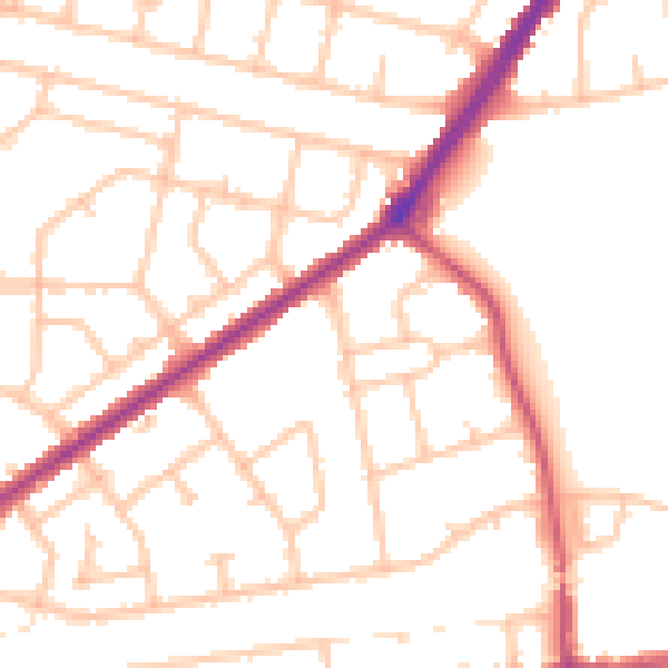
Daytime· 07:00 – 23:00
51.2dB

Night-time· 23:00 – 07:00
41.3dB