114 Overton Drive, Romford, RM6 4EE
About 114 Overton Drive
114 Overton Drive is a two-bedroom semi-detached house in Romford (RM6 4EE). It has a recorded floor area of 56 m² (around 603 sq ft), construction records dating it to 1991-1995 and council tax band C. At 56 m² this is the 31st smallest of 34 units on EPC record in the building, where floor areas span 25–68 m². The building's EPC ratings span E to B across 34 units on file. The latest certificate (May 2024) shows a C (score 77), near the top of the C band. The recommended improvements would push it to B (score 81). Main heating runs on electricity.
A recent sale: £255,000 in March 2025. At 56 m² it's 24.4% larger than the typical home in the postcode (45 m² median across 33 EPCs). Across 1995–2025, sale prices on this property compounded at 5.9% per year. On a £-per-square-foot basis, the last sale (£423/sq ft) was about 106.5% above the typical sold price in the postcode.
What this property has
Inside
- Bedrooms2
- Bathrooms1
Outside
- ParkingYes
Everything you need to know about 114 Overton Drive
The true value, the hidden risks and the full sale history, in one report.
30-day money-back guarantee

The data behind every report


Energy performance
EPC Rating
Planning history
114 Overton Drive has no planning applications on record.
Notable planning nearby
16applications of note in the surrounding area
We flagged 1 thing worth checking at 114 Overton Drive
Independent checks surfaced things a buyer would want to understand before offering. The report explains each one in full, with the underlying data and what to ask.
- Signs of HMO activity in the area
30-day money-back guarantee
Sales history & valuation
114 Overton Drive has more than quadrupled in price since its earliest registered sale in 1995.
£262,000
Modelled from EPC, postcode comparables and a sale-price growth of 5.9% per year over 30 years.
£255,000
Growth on file: 5.9% per year over 30 years.
Sales timeline
6 March 2025Most recent
£255,000
+466.7%over 30 years28 February 1995
£45,000
Median price across the last 5 sales in RM6 4EE: £215,000 (2023–2020).
Nearby sales in RM6 4EE
Versus other Overton Drive homes
On years held, 114 Overton Drive runs well behind the street norm.
Price per m²
£4,554
Street avg £3,355
Floor Area
56 m²
Street avg 44 m²
Habitable Rooms
2 rooms
Street avg 2 rooms
CO₂ Emissions
2.3 t/year
Street avg 2.6 t/year
Everything you need to know about 114 Overton Drive
The true value, the hidden risks and the full sale history, in one report.
30-day money-back guarantee
The data behind every report
Similar properties nearby
1 Bengeo Gardens
RM6 4BT
1 Crucible Close
RM6 4PZ
1 Barleyfields Close
RM6 4PF
1 Back Lane
RM6 4BP
1 Burns Avenue, Chadwell Heath
RM6 4DN
1 Chadview Court, Chadwell Heath Lane, Chadwell Heath
RM6 4BF
1 Dartford Gardens, Chadwell Heath
RM6 4FG
1 Avenue Road, Chadwell Heath
RM6 4JE
The neighbourhood at a glance
Rail-style transport is unusually close for this postcode.
Crime
6/mo
Steady year-on-year across the wider district.
Nearest stop
0.1 km
Chadwell Heath Rail Station — railway station.
Closest school
0.5 km
Chadwell Primary School. 50 schools nearby.
Go deeper on the local area
The full report breaks down crime, transport links, schools and air quality in depth.
Road noise across the postcode
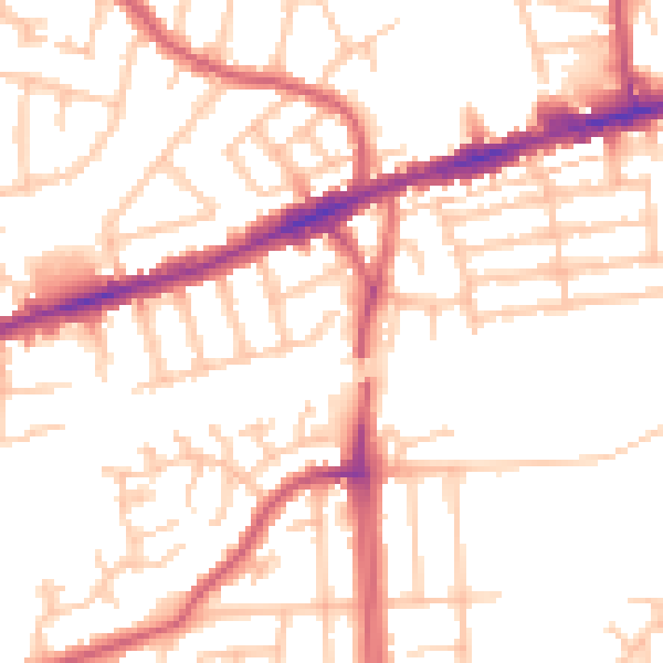
Daytime· 07:00 – 23:00
52.0dB

Night-time· 23:00 – 07:00
41.1dB