The Croft, Old School Lane, Pleasley, Mansfield, NG19 7PW
About The Croft
The Croft is a three-bedroom detached house in Pleasley, Mansfield, Mansfield (NG19 7PW). It has a recorded floor area of 88 m² (around 947 sq ft), construction records dating it to 1967-1975 and council tax band D. The latest certificate (August 2014) shows a D (score 64), on the cusp of jumping into the C band. The recommended improvements would lift it to B (score 81), a 2-band jump. The latest certificate is from August 2014, so improvements made since then won't be reflected. Other recorded features include a conservatory.
One planning record on file: an extension approved in 2025. Past consents include an extension, meaningful when judging how the property has evolved. Across 2016–2021, sale prices on this property compounded at 8.6% per year. On a £-per-square-foot basis, the last sale (£301/sq ft) was about 119.8% above the typical sold price in the postcode. Last sale on file: £285,000 in January 2021. That sale was during the post-pandemic price surge, when transactions cleared materially above pre-2020 trend.
What this property has
Inside
- Bedrooms3
- Bathrooms2
- Dining roomYes
- ConservatoryYes
Outside
- Private gardenYes
- DrivewayYes
Everything you need to know about The Croft
The true value, the hidden risks and the full sale history, in one report.
Pick your report · every report is £14.99
One time fee only - money back guarantee

The data behind every report


Energy performance
Recommended upgrades on file would lift this property by multiple EPC bands.
EPC Expired
This certificate is over 10 years old and is no longer valid.Expired 01 Aug 2024
EPC Rating
Get a survey for this property
Level 2 HomeBuyer Report
We've checked 10 risk factors against the available data for this property and believe a Level 2 HomeBuyer Report could be a suitable option for you.
From £595 · Includes VAT
Planning history
The Croft has an approved side and rear extension on the planning record.
1 application on record at The Croft, Old School Lane, Pleasley, Mansfield, NG19 7PW
- Jun 2025ExtensionFullOutcome in report
Extension: Side and rear of property
Erection of single side/rear extension
- Documents
- 13 docs on file
- Reference
- 25/00153/FUL
Unlock The Croft, Old School Lane, Pleasley, Mansfield, NG19 7PW's full planning history
You're seeing the shape of it. The report has the substance.
- Every decision — granted, refused or withdrawn (1 on record)
- All 1 application on this property in full, plus 3 notable nearby
- The 13 documents, officer reports & conditions
- What the pattern means for extending or converting here
One time fee only - money back guarantee
Sales history & valuation
The latest sale landed in the post-pandemic price surge — useful context when reading the figure.
£313,000
Modelled from EPC, postcode comparables and a sale-price growth of 8.6% per year over 5 years.
£285,000
Growth on file: 8.6% per year over 5 years.
Sales timeline
21 January 2021Most recent
£285,000
+46.2%over 4 years15 June 2016
£195,000
Median price across the last 5 sales in NG19 7PW: £175,000 (2025–2020).
Nearby sales in NG19 7PW
12 Old School Lane, Pleasley, Mansfield, NG19 7PW
Sold Mar 2025
£175,0004 Old School Lane, Pleasley, Mansfield, NG19 7PW
Sold Oct 2023
£217,5008 Old School Lane, Pleasley, Mansfield, NG19 7PW
Sold Mar 2023
£150,0001 Old School Lane, Pleasley, Mansfield, NG19 7PW
Sold Oct 2020
£165,000Ambleside, 19 Old School Lane, Pleasley, Mansfield, NG19 7PW
Sold Jan 2020
£305,000
Versus other Old School Lane homes
The Croft outperforms the street on price per m² by a wide margin.
Price per m²
£3,239
Street avg £1,801
Floor Area
88 m²
Street avg 98 m²
Habitable Rooms
5 rooms
Street avg 5 rooms
CO₂ Emissions
3.6 t/year
Street avg 4.5 t/year
Everything you need to know about The Croft
The true value, the hidden risks and the full sale history, in one report.
Pick your report · every report is £14.99
One time fee only - money back guarantee
The data behind every report
Similar properties nearby
1 Cator Road, Pleasley
NG19 7RH
1 Crompton Road, Pleasley
NG19 7RG
1 Clumber Drive
NG19 7HJ
1 Deansgate, Pleasley
NG19 7QW
1 Burlington Drive
NG19 7HU
1 Cardale Road, Pleasley
NG19 7RW
1 Cranmer Grove
NG19 7JR
1 Brougham Avenue
NG19 7LA
The neighbourhood at a glance
Daytime road noise here sits well below conversation level — a quiet pocket of the postcode.
Crime
3/mo
Steady year-on-year across the wider district.
Nearest stop
0.1 km
Terrace Lane — bus stop.
Closest school
0.7 km
Anthony Bek Community Primary School. 3 schools nearby.
Go deeper on the local area
A Local Area report breaks down crime, transport links, schools and air quality in depth.
Road noise across the postcode
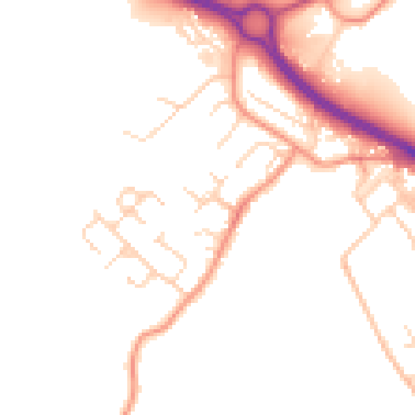
Daytime· 07:00 – 23:00
47.7dB

Night-time· 23:00 – 07:00
39.7dB