29 Holme Drive, Sudbrooke, Lincoln, LN2 2QL
About 29 Holme Drive
29 Holme Drive is a four-bedroom detached house in Sudbrooke, Lincoln, Lincoln (LN2 2QL). It has a recorded floor area of 80 m² (around 861 sq ft), construction records dating it to 1983-1990 and council tax band C. The latest certificate (June 2021) shows a D (score 68), on the cusp of jumping into the C band. The recommended improvements would lift it to B (score 86), a 2-band jump.
Across 2001–2022, sale prices on this property compounded at 6.7% per year. Today's modelled estimate of £291,000 is 10.9% above the 2022 sale price. On a £-per-square-foot basis, the last sale (£305/sq ft) was about 86.5% above the typical sold price in the postcode. At 80 m² it's 23.1% smaller than the typical home in the postcode (104 m² median across 20 EPCs). Sold February 2022 for £262,500. That sale was during the post-pandemic price surge, when transactions cleared materially above pre-2020 trend.
What this property has
Inside
- Bedrooms4
- Bathrooms2
- EnsuiteYes
Outside
- Private gardenYes
- DrivewayYes
Everything you need to know about 29 Holme Drive
The true value, the hidden risks and the full sale history, in one report.
Pick your report · every report is £14.99
One time fee only - money back guarantee

The data behind every report


Energy performance
Recommended upgrades on file would lift this property by multiple EPC bands.
EPC Rating
Get a survey for this property
Level 2 HomeBuyer Report
We've checked 10 risk factors against the available data for this property and believe a Level 2 HomeBuyer Report could be a suitable option for you.
From £545 · Includes VAT
Planning history
29 Holme Drive has no planning applications on record.
But the area is active
3 notable applications nearby — larger schemes and conversions that could reshape the street. The report maps them all.
Sales history & valuation
29 Holme Drive has more than tripled in price since its earliest registered sale in 2001.
£291,000
Modelled from EPC, postcode comparables and a sale-price growth of 6.7% per year over 21 years.
£262,500
Growth on file: 6.7% per year over 21 years.
Sales timeline
21 February 2022Most recent
£262,500
+286.0%over 20 years9 April 2001
£68,000
Median price across the last 5 sales in LN2 2QL: £300,000 (2025–2022).
Nearby sales in LN2 2QL
23 Holme Drive, Sudbrooke, Lincoln, LN2 2QL
Sold Apr 2025
£325,00025 Holme Drive, Sudbrooke, Lincoln, LN2 2QL
Sold Mar 2025
£257,50011 Holme Drive, Sudbrooke, Lincoln, LN2 2QL
Sold Mar 2023
£405,0007 Holme Drive, Sudbrooke, Lincoln, LN2 2QL
Sold Mar 2022
£300,00020 Holme Drive, Sudbrooke, Lincoln, LN2 2QL
Sold Sept 2021
£225,000
Versus other Holme Drive homes
29 Holme Drive outperforms the street on price per m² by a wide margin.
Price per m²
£3,281
Street avg £2,180
Floor Area
80 m²
Street avg 107 m²
Habitable Rooms
5 rooms
Street avg 5 rooms
CO₂ Emissions
3.2 t/year
Street avg 4.2 t/year
Everything you need to know about 29 Holme Drive
The true value, the hidden risks and the full sale history, in one report.
Pick your report · every report is £14.99
One time fee only - money back guarantee
The data behind every report
Similar properties nearby
1 Broad Dale Close, Sudbrooke
LN2 2FD
1 Beresford Drive, Sudbrooke
LN2 2YH
1 Ambrose Court, Nettleham
LN2 2EJ
1 Beech Close, Sudbrooke
LN2 2QW
1 Brattleby Crescent
LN2 2EB
1 Baker Drive, Nettleham
LN2 2FR
1 Aima Court, Nettleham
LN2 2XW
1 Burwell Close
LN2 2JB
The neighbourhood at a glance
Daytime road noise here sits well below conversation level — a quiet pocket of the postcode.
Crime
3/mo
Steady year-on-year across the wider district.
Nearest stop
0.2 km
Maple Drive — bus stop.
Closest school
1.4 km
Ellison Boulters Church of England Primary School. 5 schools nearby.
Go deeper on the local area
A Local Area report breaks down crime, transport links, schools and air quality in depth.
Road noise across the postcode
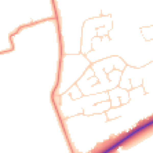
Daytime· 07:00 – 23:00
47.9dB

Night-time· 23:00 – 07:00
38.0dB