35 Browning Road, Waltham Forest, London, E11 3AR
About 35 Browning Road
35 Browning Road is a two-bedroom detached house in Waltham Forest, London, London (E11 3AR). It has a recorded floor area of 73 m² (around 786 sq ft), construction records dating it to before 1900 and council tax band D. Tenure is freehold. The latest certificate (October 2023) shows an E (score 47), well below the UK norm with real room to improve. The rating has held steady at E across 2 certificates since June 2013. Between certificates, lighting went from Very Poor to Poor. The recommended improvements would lift it to B (score 85), a 3-band jump. Period features are noted in the property record.
At 73 m² it's 25.9% larger than the typical home in the postcode (58 m² median across 57 EPCs). On energy efficiency it sits in the bottom 10% of properties in this postcode — significant headroom for improvement. Across 2007–2024, sale prices on this property compounded at 3.5% per year. Today's modelled estimate of £815,000 is 11.6% above the 2024 sale price. On a £-per-square-foot basis, the last sale (£929/sq ft) was about 143.5% above the typical sold price in the postcode. Last sale on file: £730,000 in April 2024. One historical planning record sits against the property in 2008.
Know exactly what you're buying at 35 Browning Road
Before you offer, see what the listing won't tell you, the true value, the red flags and the full history.
Already flagged here
Valuation
against the asking price
Risks
planning & flood
Sold prices
similar homes nearby
Trends
the local market
What this property has
Inside
- Bedrooms2
- Bathrooms1
- Dining roomYes
Outside
- Private gardenSouth-west-facing
- ParkingOff street
Building
- TenureFreehold
- Period featuresYes
Energy performance
35 Browning Road sits at the bottom of the postcode for energy efficiency — meaningful headroom to improve.
EPC Rating
Planning history
- Jul 2008RenovationFullIn report
Rebuilding chimney, works to facade, roof lights to rear and new retiling to roof at rear as shown in drawing nos. 001, 012, 020, 021, 022, 103, 104, 105, 110, 111, 112, 120, 121, and 122 as received on 31st March 2008.
- Council
- LEYTONSTONE
- Documents
- 5 docs on file
- Reference
- 080325
We flagged 1 thing worth checking at 35 Browning Road
Independent checks surfaced things a buyer would want to understand before offering. The report explains each one in full, with the underlying data and what to ask.
- Signs of HMO activity in the area
30-day money-back guarantee
Sales history & valuation
35 Browning Road valuation sits well clear of the typical sold price in this postcode.
£815,000
Modelled from EPC, postcode comparables and a sale-price growth of 3.5% per year over 16 years.
£730,000
Growth on file: 3.5% per year over 16 years.
Sales timeline
25 April 2024Most recent
£730,000
+75.9%over 16 years13 December 2007
£415,000
Median price across the last 5 sales in E11 3AR: £584,000 (2025–2024).
Nearby sales in E11 3AR
55 Browning Road, Waltham Forest, London, E11 3AR
Sold Jun 2025
£655,00054 Browning Road, Waltham Forest, London, E11 3AR
Sold Nov 2024
£685,00019 Browning Road, Waltham Forest, London, E11 3AR
Sold Oct 2024
£584,00060 Browning Road, Waltham Forest, London, E11 3AR
Sold Sept 2024
£330,0002a, Browning Road, Waltham Forest, London, E11 3AR
Sold Aug 2024
£400,000
Everything we know about 35 Browning Road, in one report
What it's really worth, what could be wrong, and the planning, sales and area data in full.
What we flagged
- Signs of HMO activity in the area

Versus other Browning Road homes
35 Browning Road is notably below the street on epc rating.
Price per m²
£10,000
Street avg £5,991
Floor Area
73 m²
Street avg 73 m²
Habitable Rooms
4 rooms
Street avg 4 rooms
CO₂ Emissions
4.2 t/year
Street avg 3.4 t/year
Similar properties nearby
1 Belton Road, Waltham Forest
E11 3JD
1 Elsham Road, Waltham Forest
E11 3JH
1 Aylmer Road, Waltham Forest
E11 3AD
1 Burden Way, Redbridge
E11 3RY
1 Browning Road, Waltham Forest
E11 3AR
1 Chichester Road, Waltham Forest
E11 3LH
1 Grove Road, Waltham Forest
E11 3AN
1 Barclay Road, Waltham Forest
E11 3DQ
The neighbourhood at a glance
Rail-style transport is unusually close for this postcode.
Crime
5/mo
Rising year-on-year across the wider district.
Nearest stop
0.1 km
Green Man Roundabout — bus stop.
Closest school
0.6 km
George Tomlinson Primary School. 57 schools nearby.
Go deeper on the local area
The full report breaks down crime, transport links, schools and air quality in depth.
Road noise across the postcode
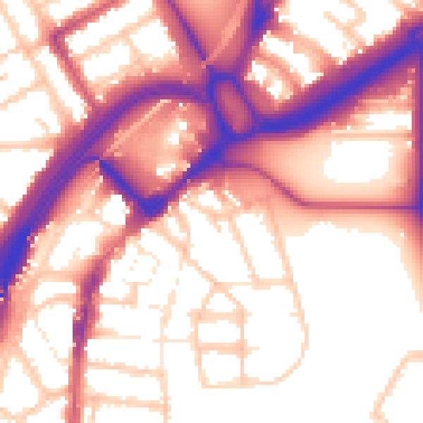
Daytime· 07:00 – 23:00
57.3dB

Night-time· 23:00 – 07:00
48.4dB