13 Radnor Road, Horfield, Bristol, BS7 8QS
About 13 Radnor Road
13 Radnor Road is a six-bedroom mid-terrace house in Horfield, Bristol, Bristol (BS7 8QS). It has a recorded floor area of 111 m² (around 1195 sq ft), construction records dating it to before 1900 and council tax band C. The latest certificate (August 2018) shows a D (score 66), on the cusp of jumping into the C band. When first surveyed in October 2008 the rating was F, the property has climbed 2 bands since. Between certificates, roof efficiency went from Very Poor to Average, window efficiency went from Poor to Average and hot-water efficiency went from Average to Good. The recommended improvements would lift it to B (score 84), a 2-band jump.
Untraded for 26 years, with the last transfer in May 2000. Across 1995–2000, sale prices on this property compounded at 15.9% per year. Today's modelled estimate of £526,000 sits 324.2% above the 2000 sale of £124,000. On a £-per-square-foot basis, the last sale (£104/sq ft) was about 46.1% below the postcode norm. 6 bedrooms is on the larger side for this postcode, where 3 is the typical count.
What this property has
Inside
- Bedrooms6
- Bathrooms2
- Utility roomYes
Building
- Heating systemGas
- RefurbishedYes
Everything you need to know about 13 Radnor Road
The true value, the hidden risks and the full sale history, in one report.
Pick your report · every report is £14.99
One time fee only - money back guarantee

The data behind every report


Energy performance
Recommended upgrades on file would lift this property by multiple EPC bands.
EPC Rating
Property Improvements
Changes detected from historical EPC data
Hot water efficiency improved
Windows upgraded, improving insulation
Roof insulation improved
Heating controls upgraded for better temperature management
Get a survey for this property
Level 3 Building Survey
Because the property was built before 1919 and has been extended more than once, we believe a Level 3 building survey should be considered.
From £1,085 · Includes VAT
Planning history
13 Radnor Road has no planning applications on record.
But the area is active
37 notable applications nearby — larger schemes and conversions that could reshape the street. The report maps them all.
Sales history & valuation
13 Radnor Road has more than doubled in price since the earliest registered sale in 1995.
£526,000
Modelled from EPC, postcode comparables and a sale-price growth of 15.9% per year over 5 years.
£124,000
Growth on file: 15.9% per year over 5 years.
Sales timeline
11 May 2000Most recent
£124,000
+36.3%over 2 years20 March 1998
£91,000
+61.1%over 3 years9 January 1995
£56,500
Median price across the last 5 sales in BS7 8QS: £500,000 (2024–2016).
Nearby sales in BS7 8QS
3 Radnor Road, Horfield, Bristol, BS7 8QS
Sold Aug 2024
£485,0009 Radnor Road, Horfield, Bristol, BS7 8QS
Sold Jan 2022
£660,00029 Radnor Road, Horfield, Bristol, BS7 8QS
Sold May 2021
£500,00059 Radnor Road, Horfield, Bristol, BS7 8QS
Sold Oct 2016
£452,00025 Radnor Road, Horfield, Bristol, BS7 8QS
Sold May 2016
£416,000
Versus other Radnor Road homes
13 Radnor Road outperforms the street on habitable rooms by a wide margin.
Price per m²
£1,117
Street avg £2,563
Floor Area
111 m²
Street avg 110 m²
Habitable Rooms
7 rooms
Street avg 6 rooms
CO₂ Emissions
4.2 t/year
Street avg 4.6 t/year
Everything you need to know about 13 Radnor Road
The true value, the hidden risks and the full sale history, in one report.
Pick your report · every report is £14.99
One time fee only - money back guarantee
The data behind every report
Similar properties nearby
1 Ash Road
BS7 8RN
1 Berkeley Avenue, Bishopston
BS7 8HH
1 3, Gloucester Road, Bishopston
BS7 8AA
1 Arundel Road
BS7 8HA
1 Beloe Mews
BS7 8AN
1 Beloe Road
BS7 8RB
1 Arundel Court, Berkeley Road, Bishopston
BS7 8HE
1 2, Flat 3, Hunts Lane
BS7 8UW
The neighbourhood at a glance
Rail-style transport is unusually close for this postcode.
Crime
6/mo
Rising year-on-year across the wider district.
Nearest stop
0.2 km
Ashley Down Road — bus stop.
Closest school
0.3 km
Bishop Road Primary School. 45 schools nearby.
Go deeper on the local area
A Local Area report breaks down crime, transport links, schools and air quality in depth.
Road noise across the postcode
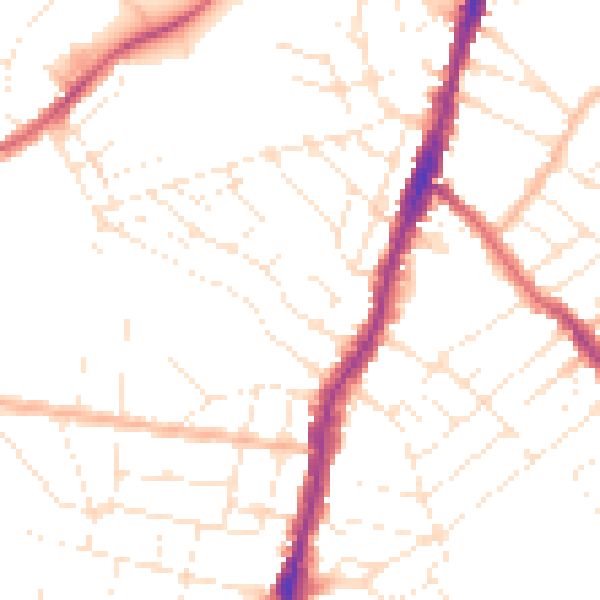
Daytime· 07:00 – 23:00
49.6dB

Night-time· 23:00 – 07:00
39.3dB