21 Links Road, West Wickham, BR4 0QN
About 21 Links Road
21 Links Road is a property in West Wickham (BR4 0QN). It has council tax band F.
Held since June 2005 — that's 21 years off the open market, well above the local norm. 2 planning records sit against the property, 1 approved, 0 refused. Across 1997–2005, sale prices on this property compounded at 12.1% per year.
Know exactly what you're buying at 21 Links Road
Before you offer, see what the listing won't tell you, the true value, the red flags and the full history.
Already flagged here
Valuation
against the asking price
Risks
planning & flood
Sold prices
similar homes nearby
Trends
the local market
Energy performance
No EPC on record
This property doesn't have an Energy Performance Certificate yet. An EPC is required to sell or let — and unlocks our automated valuation.
Planning history
- May 2016OutlineIn report
Hip to gable roof extension, rear dormer and front rooflights Lawful Development Certificate (Proposed)
- Agent
- range property consultants
- Documents
- 6 docs on file
- Reference
- 16/01634/PLUD
- May 2008RenovationFullIn report
Replacement pitched roof to existing rear extension
- Documents
- 2 docs on file
- Reference
- 08/01141/FULL6
We flagged 1 thing worth checking at 21 Links Road
Independent checks surfaced things a buyer would want to understand before offering. The report explains each one in full, with the underlying data and what to ask.
- Larger development activity nearby
30-day money-back guarantee
Sales history & valuation
21 Links Road has more than doubled in price since the earliest registered sale in 1997.
£380,000
Growth on file: 12.1% per year over 7 years.
Sales timeline
15 June 2005Most recent
£380,000
+136.0%over 7 years15 December 1997
£161,000
Median price across the last 5 sales in BR4 0QN: £750,000 (2025–2017).
Nearby sales in BR4 0QN
Everything we know about 21 Links Road, in one report
What it's really worth, what could be wrong, and the planning, sales and area data in full.
What we flagged
- Larger development activity nearby

Similar properties nearby
The neighbourhood at a glance
Rail-style transport is unusually close for this postcode.
Crime
3/mo
Steady year-on-year across the wider district.
Nearest stop
0.3 km
Station Road / High Street — bus stop.
Closest school
0.4 km
Hawes Down Primary School. 31 schools nearby.
Go deeper on the local area
The full report breaks down crime, transport links, schools and air quality in depth.
Road noise across the postcode
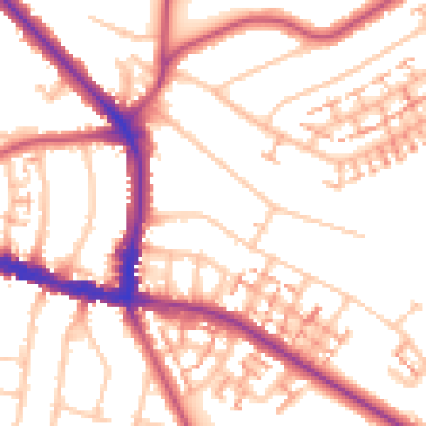
Daytime· 07:00 – 23:00
53.7dB

Night-time· 23:00 – 07:00
42.7dB