21 Hatfield Road, Bradford, BD2 4QX
About 21 Hatfield Road
21 Hatfield Road is a three-bedroom mid-terrace house in Bradford (BD2 4QX). It has a recorded floor area of 75 m² (around 807 sq ft), construction records dating it to before 1900 and council tax band A. The latest certificate (October 2024) shows an E (score 52), well below the UK norm with real room to improve. The recommended improvements would lift it to B (score 83), a 3-band jump.
Today's modelled estimate of £139,000 sits 63.5% above the 2025 sale of £85,000. On a £-per-square-foot basis, the last sale (£105/sq ft) was about 49% above the typical sold price in the postcode. A recent sale: £85,000 in April 2025.
What this property has
Inside
- Bedrooms3
- Bathrooms1
Outside
- Private gardenYes
Building
- RefurbishedYes
Everything you need to know about 21 Hatfield Road
The true value, the hidden risks and the full sale history, in one report.
Pick your report · every report is £14.99
One time fee only - money back guarantee

The data behind every report


Energy performance
Recommended upgrades on file would lift this property by multiple EPC bands.
EPC Rating
Get a survey for this property
Level 3 Building Survey
Because the property was built before 1919, we believe a Level 3 building survey should be considered.
From £820 · Includes VAT
Planning history
21 Hatfield Road has no planning applications on record.
But the area is active
2 notable applications nearby — larger schemes and conversions that could reshape the street. The report maps them all.
Sales history & valuation
21 Hatfield Road valuation sits well clear of the typical sold price in this postcode.
£139,000
Modelled from EPC, postcode comparables.
£85,000
Recorded with HM Land Registry.
Sales timeline
8 April 2025Most recent
£85,000
Median price across the last 5 sales in BD2 4QX: £100,000 (2025–2024).
Nearby sales in BD2 4QX
Versus other Hatfield Road homes
21 Hatfield Road is notably below the street on years held.
Price per m²
£1,133
Street avg £993
Floor Area
75 m²
Street avg 86 m²
Habitable Rooms
4 rooms
Street avg 5 rooms
CO₂ Emissions
4.9 t/year
Street avg 5.5 t/year
Everything you need to know about 21 Hatfield Road
The true value, the hidden risks and the full sale history, in one report.
Pick your report · every report is £14.99
One time fee only - money back guarantee
The data behind every report
Similar properties nearby
The neighbourhood at a glance
Crime
3/mo
Steady year-on-year across the wider district.
Nearest stop
0.1 km
Idle Road — bus stop.
Closest school
0.3 km
Peel Park Primary School and Nursery. 44 schools nearby.
Go deeper on the local area
A Local Area report breaks down crime, transport links, schools and air quality in depth.
Road noise across the postcode
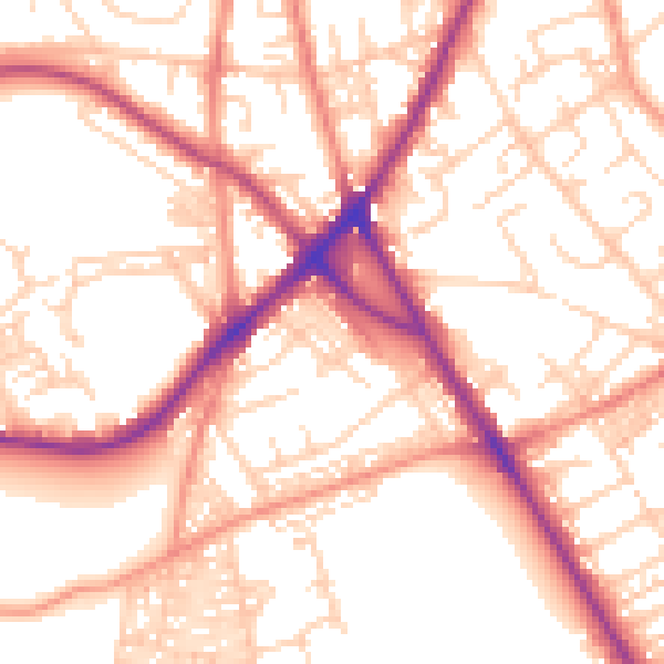
Daytime· 07:00 – 23:00
54.5dB

Night-time· 23:00 – 07:00
44.0dB