1 Dace Road, Wolverhampton, WV10 0TH
About 1 Dace Road
1 Dace Road is a four-bedroom end-of-terrace house in Wolverhampton (WV10 0TH). It has a recorded floor area of 123 m² (around 1324 sq ft), construction records dating it to 1996-2002 and council tax band C. The latest certificate (May 2015) shows a D (score 67), on the cusp of jumping into the C band. The recommended improvements would push it to C (score 77). The latest certificate is from May 2015, so improvements made since then won't be reflected.
Untraded for 22 years, with the last transfer in December 2003. Across 2002–2003, sale prices on this property compounded at -5.7% per year. Today's modelled estimate of £276,000 sits 104.4% above the 2003 sale of £135,000. At 123 m² it's 23.4% larger than the typical home in the postcode (100 m² median across 8 EPCs).
What this property has
Inside
- Bedrooms4
- Bathrooms2
- Open-plan layoutYes
- EnsuiteYes
Outside
- Private gardenYes
Everything you need to know about 1 Dace Road
The true value, the hidden risks and the full sale history, in one report.
Pick your report · every report is £14.99
One time fee only - money back guarantee

The data behind every report


Energy performance
1 Dace Road's EPC is over a decade old — improvements since won't be reflected.
EPC Expired
This certificate is over 10 years old and is no longer valid.Expired 04 May 2025
EPC Rating
Get a survey for this property
Level 2 HomeBuyer Report
We've checked 10 risk factors against the available data for this property and believe a Level 2 HomeBuyer Report could be a suitable option for you.
From £545 · Includes VAT
Planning history
1 Dace Road has no planning applications on record.
But the area is active
4 notable applications nearby — larger schemes and conversions that could reshape the street. The report maps them all.
Sales history & valuation
1 Dace Road valuation sits well clear of the typical sold price in this postcode.
£276,000
Modelled from EPC, postcode comparables and a sale-price growth of -5.7% per year over 2 years.
£135,000
Growth on file: -5.7% per year over 2 years.
Sales timeline
19 December 2003Most recent
£135,000
-8.8%over 1 year30 May 2002
£147,950
Median price across the last 5 sales in WV10 0TH: £148,000 (2021–2016).
Nearby sales in WV10 0TH
Versus other Dace Road homes
1 Dace Road outperforms the street on floor area by a wide margin.
Price per m²
£1,098
Street avg £1,352
Floor Area
123 m²
Street avg 100 m²
Habitable Rooms
5 rooms
Street avg 5 rooms
CO₂ Emissions
4.5 t/year
Street avg 3.9 t/year
Everything you need to know about 1 Dace Road
The true value, the hidden risks and the full sale history, in one report.
Pick your report · every report is £14.99
One time fee only - money back guarantee
The data behind every report
Similar properties nearby
The neighbourhood at a glance
Crime
6/mo
Steady year-on-year across the wider district.
Nearest stop
1.7 km
Wolverhampton Rail Station — railway station.
Closest school
0.6 km
Heath Park. 37 schools nearby.
Go deeper on the local area
A Local Area report breaks down crime, transport links, schools and air quality in depth.
Road noise across the postcode
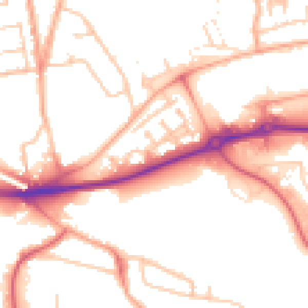
Daytime· 07:00 – 23:00
52.3dB

Night-time· 23:00 – 07:00
42.4dB