4 Lychgate, Higher Walton, Warrington, WA4 6TF
About 4 Lychgate
4 Lychgate is a five-bedroom detached house in Higher Walton, Warrington, Warrington (WA4 6TF). It has a recorded floor area of 168 m² (around 1808 sq ft), construction records dating it to 1967-1975 and council tax band F. The latest certificate (January 2016) shows a D (score 62), on the cusp of jumping into the C band. The recommended improvements would push it to C (score 72). The latest certificate is from January 2016, so improvements made since then won't be reflected.
Across 1999–2016, sale prices on this property compounded at 4.8% per year. Today's modelled estimate of £505,000 sits 60.3% above the 2016 sale of £315,000. At 168 m² it's 23% larger than the typical home in the postcode (137 m² median across 3 EPCs). On the market in April 2016 and unlisted since — roughly 10 years.
What this property has
Inside
- Bedrooms5
- Bathrooms2
Everything you need to know about 4 Lychgate
The true value, the hidden risks and the full sale history, in one report.
Pick your report · every report is £14.99
One time fee only - money back guarantee

The data behind every report


Energy performance
4 Lychgate's carbon output runs well above what efficient homes in the postcode produce.
EPC Expired
This certificate is over 10 years old and is no longer valid.Expired 07 Jan 2026
EPC Rating
Get a survey for this property
Level 2 HomeBuyer Report
We've checked 10 risk factors against the available data for this property and believe a Level 2 HomeBuyer Report could be a suitable option for you.
From £795 · Includes VAT
Planning history
4 Lychgate has no planning applications on record.
A planning report still maps activity across the surrounding area and reads this property's extension & conversion potential.
Sales history & valuation
4 Lychgate has more than doubled in price since the earliest registered sale in 1999.
£505,000
Modelled from EPC, postcode comparables and a sale-price growth of 4.8% per year over 17 years.
£315,000
Growth on file: 4.8% per year over 17 years.
Sales timeline
5 April 2016Most recent
£315,000
+31.3%over 10 years10 March 2006
£240,000
+69.6%over 7 years11 January 1999
£141,500
Median price across the last 5 sales in WA4 6TF: £235,000 (2022–2001).
Versus other Lychgate homes
On floor area, 4 Lychgate stands well clear of the street.
EPC Rating
62 (D)
Street avg 57 (D)
Floor Area
168 m²
Street avg 138 m²
CO₂ Emissions
6.9 t/year
Street avg 6.4 t/year
Habitable Rooms
8 rooms
Street avg 6 rooms
Everything you need to know about 4 Lychgate
The true value, the hidden risks and the full sale history, in one report.
Pick your report · every report is £14.99
One time fee only - money back guarantee
The data behind every report
Similar properties nearby
1 Cambridge Close, Stockton Heath
WA4 6SF
1 Carlingford Road, Stockton Heath
WA4 6SA
1 Belvoir Road, Walton
WA4 6PE
1 Carlton Street, Stockton Heath
WA4 6LX
1 Bramley Mews, Stockton Heath
WA4 6PR
1 Calderfield Close, Stockton Heath
WA4 6PJ
1 Chelford Close, Stockton Heath
WA4 6PL
1 Brackley Street, Stockton Heath
WA4 6DY
The neighbourhood at a glance
Crime
2/mo
Steady year-on-year across the wider district.
Nearest stop
0.2 km
Walton Arms — bus stop.
Closest school
1.5 km
Stockton Heath Primary School. 12 schools nearby.
Go deeper on the local area
A Local Area report breaks down crime, transport links, schools and air quality in depth.
Road noise across the postcode
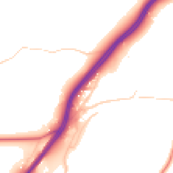
Daytime· 07:00 – 23:00
51.1dB

Night-time· 23:00 – 07:00
43.4dB