39 Cottesmore Way, Golborne, Warrington, WA3 3XJ
About 39 Cottesmore Way
39 Cottesmore Way is a three-bedroom semi-detached house in Golborne, Warrington, Warrington (WA3 3XJ). It has a recorded floor area of 89 m² (around 958 sq ft), construction records dating it to 1996-2002 and council tax band B. The latest certificate (January 2025) shows a C (score 71). The rating has held steady at C across 2 certificates since July 2013. Between certificates, lighting went from Good to Very Good; while hot-water efficiency dropped from Very Good to Good. The recommended improvements would push it to B (score 82).
Most recent transfer was March 2025 at £227,000 — fresh data. One planning record on file: an extension approved in 2014. Past consents include an extension, meaningful when judging how the property has evolved. At 89 m² it's 29% larger than the typical home in the postcode (69 m² median across 32 EPCs). Across 1999–2025, sale prices on this property compounded at 6.5% per year. On a £-per-square-foot basis, the last sale (£237/sq ft) was about 80.4% above the typical sold price in the postcode.
What this property has
Inside
- Bedrooms3
- Bathrooms1
- Dining roomYes
- Utility roomYes
- CloakroomYes
Outside
- Private gardenYes
- DrivewayYes
Everything you need to know about 39 Cottesmore Way
The true value, the hidden risks and the full sale history, in one report.
Pick your report · every report is £14.99
One time fee only - money back guarantee

The data behind every report


Energy performance
EPC Rating
Property Improvements
Changes detected from historical EPC data
Hot water efficiency decreased
Loft insulation upgraded to recommended levels
Floor insulation added or improved
More low energy lighting installed
Get a survey for this property
Level 2 HomeBuyer Report
We've checked 10 risk factors against the available data for this property and believe a Level 2 HomeBuyer Report could be a suitable option for you.
From £545 · Includes VAT
Planning history
39 Cottesmore Way has an approved side extension on the planning record.
1 application on record at 39 Cottesmore Way, Golborne, Warrington, WA3 3XJ
- Oct 2014ExtensionOutlineOutcome in report
Extension: Side of property
Certificate of Lawfulness for single storey side extension.
- Documents
- 6 docs on file
- Reference
- A/14/79674
Unlock 39 Cottesmore Way, Golborne, Warrington, WA3 3XJ's full planning history
You're seeing the shape of it. The report has the substance.
- Every decision — granted, refused or withdrawn (1 on record)
- All 1 application on this property in full, plus 3 notable nearby
- The 6 documents, officer reports & conditions
- What the pattern means for extending or converting here
One time fee only - money back guarantee
Sales history & valuation
Price for 39 Cottesmore Way has grown more than fourfold since the 1999 starting point.
£245,000
Modelled from EPC, postcode comparables and a sale-price growth of 6.5% per year over 26 years.
£227,000
Growth on file: 6.5% per year over 26 years.
Sales timeline
24 March 2025Most recent
£227,000
+66.3%over 8 years25 November 2016
£136,500
+212.0%over 17 years26 February 1999
£43,750
Median price across the last 5 sales in WA3 3XJ: £199,950 (2025–2022).
Nearby sales in WA3 3XJ
49 Cottesmore Way, Golborne, Warrington, WA3 3XJ
Sold Jul 2025
£280,00035 Cottesmore Way, Golborne, Warrington, WA3 3XJ
Sold Jul 2024
£199,95097 Cottesmore Way, Golborne, Warrington, WA3 3XJ
Sold Jul 2023
£155,0001 Cottesmore Way, Golborne, Warrington, WA3 3XJ
Sold Apr 2023
£240,00043 Cottesmore Way, Golborne, Warrington, WA3 3XJ
Sold Dec 2021
£125,000
Versus other Cottesmore Way homes
39 Cottesmore Way is notably below the street on years held.
Price per m²
£2,551
Street avg £1,939
Floor Area
89 m²
Street avg 72 m²
Habitable Rooms
4 rooms
Street avg 5 rooms
CO₂ Emissions
3.0 t/year
Street avg 3.0 t/year
Everything you need to know about 39 Cottesmore Way
The true value, the hidden risks and the full sale history, in one report.
Pick your report · every report is £14.99
One time fee only - money back guarantee
The data behind every report
Similar properties nearby
1 Barnham Close, Golborne
WA3 3XR
1 Barwell Close, Golborne
WA3 3GZ
1 Cottesmore Way, Golborne
WA3 3XJ
1 Bridge Street, Golborne
WA3 3PX
1 Cliftonmill Meadows, Golborne
WA3 3NH
1 Belton Close, Golborne
WA3 3WN
1 Ash Grove, Golborne
WA3 3LQ
1 Barton Street, Golborne
WA3 3DH
The neighbourhood at a glance
Crime
1/mo
Steady year-on-year across the wider district.
Nearest stop
0.1 km
Heywood Avenue — bus stop.
Closest school
0.2 km
St Thomas CofE Junior and Infant School. 13 schools nearby.
Go deeper on the local area
A Local Area report breaks down crime, transport links, schools and air quality in depth.
Road noise across the postcode
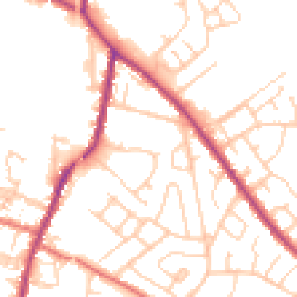
Daytime· 07:00 – 23:00
51.5dB

Night-time· 23:00 – 07:00
42.3dB