Flat 1, 3 Grotes Buildings, London, SE3 0QG
About Flat 1
Flat 1 is a mid-terrace house in London (SE3 0QG). It has a recorded floor area of 181 m² (around 1948 sq ft), construction records dating it to before 1900 and council tax band G. The latest certificate (June 2025) shows a C (score 70). When first surveyed in October 2008 the rating was D, the property has climbed 1 band since. Between certificates, window efficiency went from Very Poor to Average, hot-water efficiency went from Average to Good and lighting went from Very Poor to Very Good.
Know exactly what you're buying at Flat 1
Before you offer, see what the listing won't tell you, the true value, the red flags and the full history.
Valuation
against the asking price
Risks
planning & flood
Sold prices
similar homes nearby
Trends
the local market
Energy performance
EPC Rating
Property Improvements
Changes detected from historical EPC data
Heating controls upgraded for better temperature management
Hot water system upgraded
Single glazing replaced with double or better glazing
More low energy lighting installed
More low energy lighting installed
Planning history
Flat 1 has no planning applications on record.
Notable planning nearby
3applications of note in the surrounding area
Sales history & valuation
Flat 1 has no Land Registry sales on file, suggesting it has stayed in the same hands since registration began.
£1,377,000
Modelled from EPC, postcode comparables.
No sales recorded with HM Land Registry
That can mean the property has never traded since the registry began publishing in 1995, was a new build that hasn't been registered yet, or is held in the same hands long-term.
Median price across the last 5 sales in SE3 0QG: £510,000 (2022–1995).
Everything we know about Flat 1, in one report
What it's really worth, what could be wrong, and the planning, sales and area data in full.
- Am I paying too much?
- Is something wrong with it?
- Is the agent's story true?
- Will it hold its value?

Versus other Grotes Buildings homes
Floor Area for Flat 1 runs comfortably ahead of the street norm.
EPC Rating
70 (C)
Street avg 62 (D)
Floor Area
181 m²
Street avg 120 m²
CO₂ Emissions
5.3 t/year
Street avg 4.9 t/year
Habitable Rooms
6 rooms
Street avg 5 rooms
Similar properties nearby
2 Eliot Cottages, First Floor Flat, Hare & Billet Road
SE3 0QJ
15 16, Flat 5, Royal Parade
SE3 0TL
4 Montague Graham Court, Flat 1, Kidbrooke Gardens
SE3 0PD
4 Montague Graham Court, Flat 2, Kidbrooke Gardens
SE3 0PD
3 Montague Graham Court, Flat 1, Kidbrooke Gardens
SE3 0PD
3 Montague Graham Court, Flat 2, Kidbrooke Gardens
SE3 0PD
43a, Flat 3, Montpelier Vale
SE3 0TJ
15 16, Flat 4, Royal Parade
SE3 0TL
The neighbourhood at a glance
Rail-style transport is unusually close for this postcode.
Crime
10/mo
Rising year-on-year across the wider district.
Nearest stop
0.2 km
Hare & Billet Road — bus stop.
Closest school
0.1 km
John Ball Primary School. 63 schools nearby.
Go deeper on the local area
The full report breaks down crime, transport links, schools and air quality in depth.
Road noise across the postcode
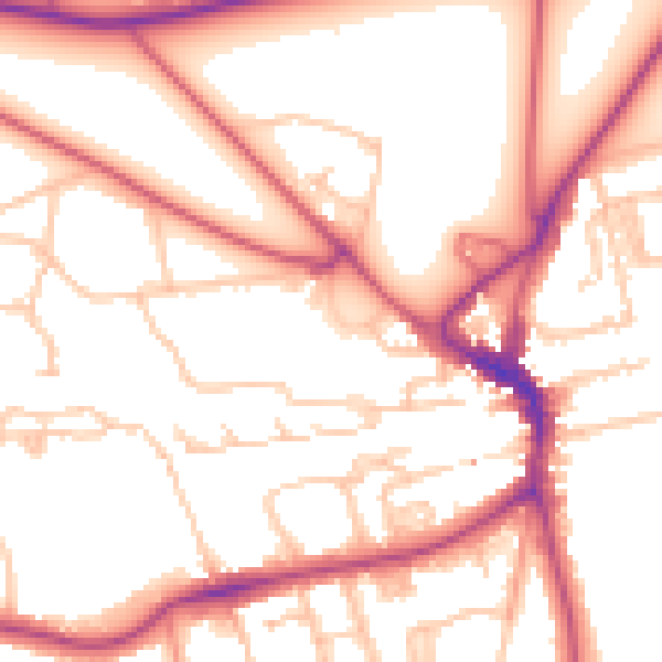
Daytime· 07:00 – 23:00
53.8dB

Night-time· 23:00 – 07:00
43.8dB