11 Florence Road, Bexley, London, SE2 9HB
About 11 Florence Road
11 Florence Road is a mid-terrace house in Bexley, London, London (SE2 9HB). It has a recorded floor area of 71 m² (around 764 sq ft), construction records dating it to 1930-1949 and council tax band C. The latest certificate (May 2016) shows a D (score 61), on the cusp of jumping into the C band. The recommended improvements would lift it to B (score 84), a 2-band jump. The latest certificate is from May 2016, so improvements made since then won't be reflected.
Today's modelled estimate of £382,000 is 17.5% above the 2016 sale price. On a £-per-square-foot basis, the last sale (£425/sq ft) was about 110.2% above the typical sold price in the postcode. Last sold in October 2016, so it's been off the market for around 10 years.
Everything you need to know about 11 Florence Road
The true value, the hidden risks and the full sale history, in one report.
Pick your report · every report is £14.99
One time fee only - money back guarantee

The data behind every report


Energy performance
Recommended upgrades on file would lift this property by multiple EPC bands.
EPC Expired
This certificate is over 10 years old and is no longer valid.Expired 23 May 2026
EPC Rating
Get a survey for this property
Level 3 Building Survey
Because the property has solid (non-cavity) walls, we believe a Level 3 building survey should be considered.
From £955 · Includes VAT
Planning history
11 Florence Road has no planning applications on record.
But the area is active
12 notable applications nearby — larger schemes and conversions that could reshape the street. The report maps them all.
Sales history & valuation
11 Florence Road valuation sits well clear of the typical sold price in this postcode.
£382,000
Modelled from EPC, postcode comparables.
£325,000
Recorded with HM Land Registry.
Sales timeline
12 October 2016Most recent
£325,000
Median price across the last 5 sales in SE2 9HB: £235,000 (2022–2013).
Nearby sales in SE2 9HB
13a, Florence Road, Bexley, London, SE2 9HB
Sold Sept 2022
£235,0003 Florence Road, Bexley, London, SE2 9HB
Sold Jul 2021
£385,00023 Florence Road, Bexley, London, SE2 9HB
Sold Aug 2014
£265,0007 Florence Road, Bexley, London, SE2 9HB
Sold Dec 2013
£205,00013b, Florence Road, Bexley, London, SE2 9HB
Sold Feb 2005
£150,000
Versus other Florence Road homes
11 Florence Road is notably below the street on epc rating.
Price per m²
£4,577
Street avg £3,348
Floor Area
71 m²
Street avg 81 m²
Habitable Rooms
4 rooms
Street avg 5 rooms
CO₂ Emissions
3.4 t/year
Street avg 3.0 t/year
Everything you need to know about 11 Florence Road
The true value, the hidden risks and the full sale history, in one report.
Pick your report · every report is £14.99
One time fee only - money back guarantee
The data behind every report
Similar properties nearby
1 Blithdale Road, Greenwich
SE2 9HW
1 Abbey Wood Road, Greenwich
SE2 9ED
1 Grovebury Road, Greenwich
SE2 9YA
1 Boxgrove Road, Greenwich
SE2 9JZ
1 Edington Road, Greenwich
SE2 9JU
1 Bromholm Road, Greenwich
SE2 9NE
1 Bracondale Road, Greenwich
SE2 9HR
1 Glover Close, Greenwich
SE2 9DX
The neighbourhood at a glance
Rail-style transport is unusually close for this postcode.
Crime
7/mo
Rising year-on-year across the wider district.
Nearest stop
0.0 km
Harrow Manorway / Abbey Wood Station — bus stop.
Closest school
0.5 km
Boxgrove Primary School. 45 schools nearby.
Go deeper on the local area
A Local Area report breaks down crime, transport links, schools and air quality in depth.
Road noise across the postcode
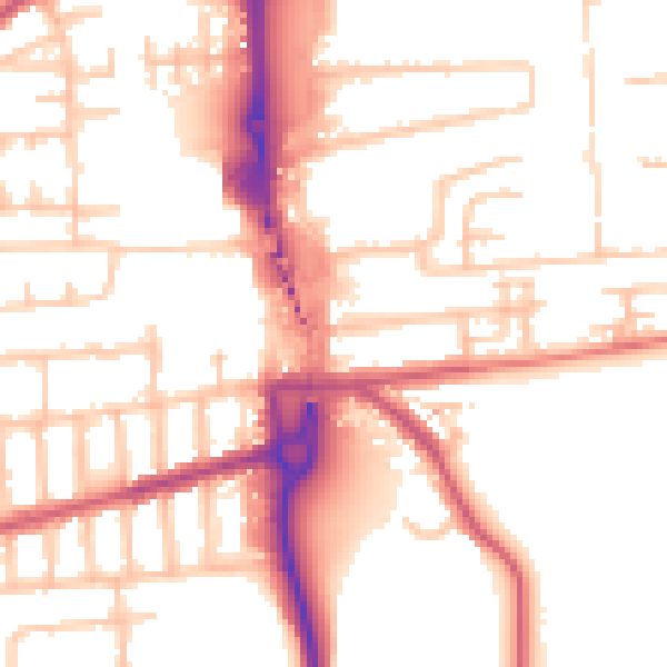
Daytime· 07:00 – 23:00
53.5dB
Night-time· 23:00 – 07:00
43.3dB