7 Burnham Road, Romford, RM7 7JP
About 7 Burnham Road
7 Burnham Road is a three-bedroom mid-terrace house in Romford (RM7 7JP). It has a recorded floor area of 93 m² (around 1001 sq ft), construction records dating it to 1900-1929 and council tax band C. The latest certificate (February 2025) shows a C (score 70). When first surveyed in January 2011 the rating was D, the property has climbed 1 band since. Between certificates, roof efficiency went from Very Poor to Good and lighting went from Very Poor to Very Good; while window efficiency dropped from Good to Average. The recommended improvements would push it to B (score 87).
Across 1995–2011, sale prices on this property compounded at 11.5% per year. Today's modelled estimate of £437,000 sits 94.2% above the 2011 sale of £225,000. On a £-per-square-foot basis, the last sale (£225/sq ft) was about 20.7% below the postcode norm. Last changed hands 15 years ago, in July 2011. Across the public record there are 4 sales, relatively high churn for a single property. At 93 m² it's 16.9% larger than the typical home in the postcode (80 m² median across 6 EPCs). Its energy rating outperforms most of the postcode (better than 83% of similar EPCs).
What this property has
Inside
- Bedrooms3
- Bathrooms1
Everything you need to know about 7 Burnham Road
The true value, the hidden risks and the full sale history, in one report.
30-day money-back guarantee

The data behind every report


Energy performance
EPC Rating
Property Improvements
Changes detected from historical EPC data
Heating controls upgraded for better temperature management
Loft insulation installed or upgraded to 250mm+
More low energy lighting installed
Planning history
7 Burnham Road has no planning applications on record.
Notable planning nearby
12applications of note in the surrounding area
We flagged 1 thing worth checking at 7 Burnham Road
Independent checks surfaced things a buyer would want to understand before offering. The report explains each one in full, with the underlying data and what to ask.
- Signs of HMO activity in the area
30-day money-back guarantee
Sales history & valuation
Price for 7 Burnham Road has grown more than fourfold since the 1995 starting point.
£437,000
Modelled from EPC, postcode comparables and a sale-price growth of 11.5% per year over 16 years.
£225,000
Growth on file: 11.5% per year over 16 years.
Sales timeline
7 July 2011Most recent
£225,000
+116.3%over 11 years16 March 2000
£104,000
+108.0%over 3 years23 May 1996
£50,000
+23.5%over 7 months25 October 1995
£40,500
Median price across the last 5 sales in RM7 7JP: £346,000 (2021–2015).
Versus other Burnham Road homes
Price per m² for 7 Burnham Road lags the street by a wide margin.
Price per m²
£2,419
Street avg £3,843
Floor Area
93 m²
Street avg 93 m²
Habitable Rooms
5 rooms
Street avg 5 rooms
CO₂ Emissions
3.1 t/year
Street avg 4.1 t/year
Everything you need to know about 7 Burnham Road
The true value, the hidden risks and the full sale history, in one report.
30-day money-back guarantee
The data behind every report
Similar properties nearby
1 Willow Street
RM7 7LJ
1 Cedar Road
RM7 7JR
1 Drummond Avenue
RM7 7EH
1 Maple Street
RM7 7JX
1 Marshalls Road
RM7 7EL
1 Cherry Street
RM7 7LL
1 Amanda Mews, Pretoria Road
RM7 7BL
10 Beech Street
RM7 7LA
The neighbourhood at a glance
Reported crime in the wider district is trending notably upward year-on-year.
Crime
7/mo
Rising year-on-year across the wider district.
Nearest stop
0.1 km
Cedar Road (RM5) — bus stop.
Closest school
0.5 km
Parklands Primary School. 32 schools nearby.
Go deeper on the local area
The full report breaks down crime, transport links, schools and air quality in depth.
Road noise across the postcode
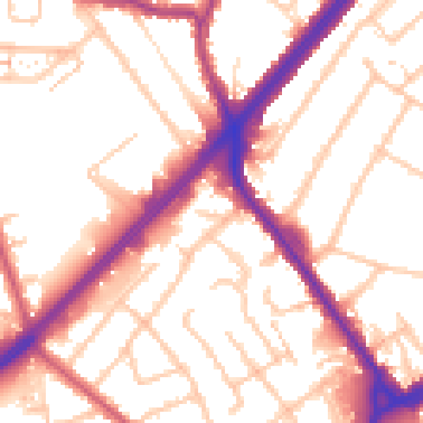
Daytime· 07:00 – 23:00
54.3dB

Night-time· 23:00 – 07:00
45.7dB