77 Claygate Lane, Esher, KT10 0BQ
About 77 Claygate Lane
77 Claygate Lane is a property in Esher (KT10 0BQ). It has council tax band G.
Untraded for 27 years, with the last transfer in August 1999. Only one transfer is on record with HM Land Registry, suggesting it has stayed in the same hands for a long time.
Know exactly what you're buying at 77 Claygate Lane
Before you offer, see what the listing won't tell you, the true value, the red flags and the full history.
Already flagged here
Valuation
against the asking price
Risks
planning & flood
Sold prices
similar homes nearby
Trends
the local market
Energy performance
No EPC on record
This property doesn't have an Energy Performance Certificate yet. An EPC is required to sell or let — and unlocks our automated valuation.
Planning history
77 Claygate Lane has no planning applications on record.
Notable planning nearby
8applications of note in the surrounding area
We flagged 1 thing worth checking at 77 Claygate Lane
Independent checks surfaced things a buyer would want to understand before offering. The report explains each one in full, with the underlying data and what to ask.
- Larger development activity nearby
30-day money-back guarantee
Sales history & valuation
77 Claygate Lane has been held in the same hands since before 2000.
£385,000
Recorded with HM Land Registry.
Sales timeline
23 August 1999Most recent
£385,000
Median price across the last 5 sales in KT10 0BQ: £1,085,000 (2023–2018).
Nearby sales in KT10 0BQ
Everything we know about 77 Claygate Lane, in one report
What it's really worth, what could be wrong, and the planning, sales and area data in full.
What we flagged
- Larger development activity nearby

Similar properties nearby
1 Albury Place, Hare Lane, Claygate
KT10 0RB
1 Applegarth, Claygate
KT10 0ED
1 Ashton Place, Claygate
KT10 0BN
1 Aston Road, Claygate
KT10 0RR
1 Athlone, Albany Crescent, Claygate
KT10 0PF
1 Barn Close
KT10 0EZ
1 Beaconsfield Gardens, Claygate
KT10 0PX
1 Beaconsfield Road, Claygate
KT10 0PN
The neighbourhood at a glance
Rail-style transport is unusually close for this postcode.
Crime
3/mo
Steady year-on-year across the wider district.
Nearest stop
0.5 km
Hinchley Wood School — bus stop.
Closest school
0.3 km
Hinchley Wood Primary School. 26 schools nearby.
Go deeper on the local area
The full report breaks down crime, transport links, schools and air quality in depth.
Road noise across the postcode
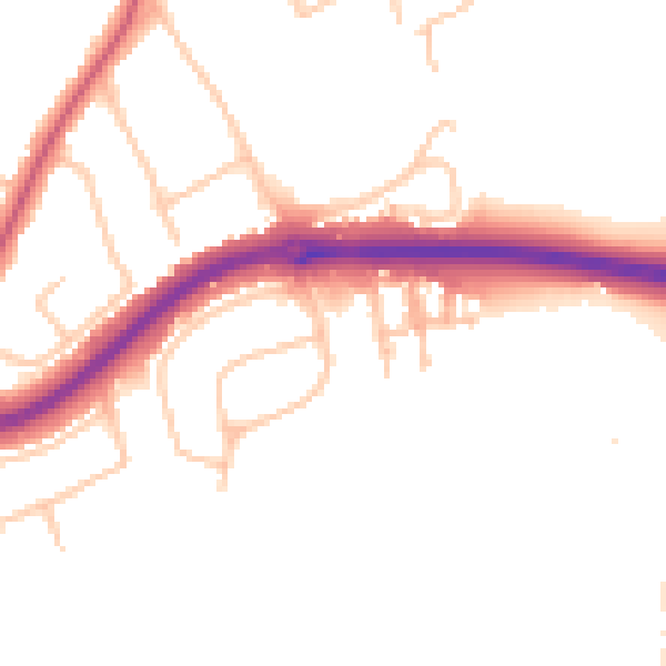
Daytime· 07:00 – 23:00
50.7dB

Night-time· 23:00 – 07:00
43.0dB