2 Alamein Close, Broxbourne, EN10 7TF
About 2 Alamein Close
2 Alamein Close is a four-bedroom detached house in Broxbourne (EN10 7TF). It has a recorded floor area of 152 m² (around 1633 sq ft), construction records dating it to 1996-2002 and council tax band G. The latest certificate (November 2009) shows a C (score 70). The latest certificate is from November 2009, so improvements made since then won't be reflected.
Across 1998–2018, sale prices on this property compounded at 6.1% per year. Today's modelled estimate of £788,000 is 15% above the 2018 sale price. On a £-per-square-foot basis, the last sale (£420/sq ft) was about 73.1% above the typical sold price in the postcode. Sold November 2018 for £685,000.
What this property has
Inside
- Bedrooms4
- Bathrooms3
- Dining roomYes
- EnsuiteYes
Outside
- GarageIntegral
Building
- RefurbishedYes
Everything you need to know about 2 Alamein Close
The true value, the hidden risks and the full sale history, in one report.
30-day money-back guarantee

The data behind every report


Energy performance
2 Alamein Close's EPC is over a decade old — improvements since won't be reflected.
EPC Expired
This certificate is over 10 years old and is no longer valid.Expired 13 Nov 2019
EPC Rating
Planning history
2 Alamein Close has no planning applications on record.
Notable planning nearby
2applications of note in the surrounding area
We flagged 1 thing worth checking at 2 Alamein Close
Independent checks surfaced things a buyer would want to understand before offering. The report explains each one in full, with the underlying data and what to ask.
- Larger development activity nearby
30-day money-back guarantee
Sales history & valuation
Sale price has grown by over 3x since 1998.
£788,000
Modelled from EPC, postcode comparables and a sale-price growth of 6.1% per year over 20 years.
£685,000
Growth on file: 6.1% per year over 20 years.
Sales timeline
30 November 2018Most recent
£685,000
+230.1%over 20 years23 September 1998
£207,500
Median price across the last 5 sales in EN10 7TF: £722,000 (2024–2017).
Nearby sales in EN10 7TF
Versus other Alamein Close homes
2 Alamein Close outperforms the street on habitable rooms by a wide margin.
Price per m²
£4,515
Street avg £4,073
Floor Area
152 m²
Street avg 160 m²
Habitable Rooms
9 rooms
Street avg 7 rooms
CO₂ Emissions
4.9 t/year
Street avg 4.8 t/year
Everything you need to know about 2 Alamein Close
The true value, the hidden risks and the full sale history, in one report.
30-day money-back guarantee
The data behind every report
Similar properties nearby
1 Alexis Row, High Road
EN10 7FJ
1 Badgers Croft
EN10 7ED
1 Borrell Close
EN10 7RD
1 Church View
EN10 7AB
1 Baas Lane
EN10 7EL
1 Beaumont Manor, Beaumont Road
EN10 7QJ
1 Bassingbourne Close
EN10 7PW
1 Baas Hill Close
EN10 7EU
The neighbourhood at a glance
Crime
3/mo
Steady year-on-year across the wider district.
Nearest stop
0.9 km
Station Road — bus stop.
Closest school
0.9 km
Sheredes Primary School. 10 schools nearby.
Go deeper on the local area
The full report breaks down crime, transport links, schools and air quality in depth.
Road noise across the postcode
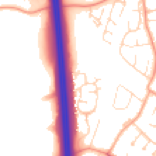
Daytime· 07:00 – 23:00
52.8dB
Night-time· 23:00 – 07:00
44.5dB