23 Bassingbourne Close, Broxbourne, EN10 7PW
About 23 Bassingbourne Close
23 Bassingbourne Close is a property in Broxbourne (EN10 7PW). It has council tax band G.
It hasn't traded since December 1997, a hold of 28 years that's notably long for the area. Only one transfer is on record with HM Land Registry, suggesting it has stayed in the same hands for a long time. 6 planning records sit against the property, 2 approved, 0 refused. Past consents include an extension, meaningful when judging how the property has evolved.
Everything you need to know about 23 Bassingbourne Close
The true value, the hidden risks and the full sale history, in one report.
30-day money-back guarantee

The data behind every report


Energy performance
No EPC on record
This property doesn't have an Energy Performance Certificate yet. An EPC is required to sell or let — and unlocks our automated valuation.
Planning history
23 Bassingbourne Close has been extended on multiple sides of the property across separate planning applications.
- Jun 2019Tree WorksTreesIn report
Oak tree located in rear garden - J Yull has inspected the tree and Oak has died the tree has rotted and root system has died. Fell and remove No replacement has been proposed.
- Documents
- 8 docs on file
- Reference
- 07/19/0434/TW
- Feb 2016
We flagged 1 thing worth checking at 23 Bassingbourne Close
Independent checks surfaced things a buyer would want to understand before offering. The report explains each one in full, with the underlying data and what to ask.
- Larger development activity nearby
30-day money-back guarantee
Sales history & valuation
23 Bassingbourne Close has been held in the same hands since before 2000.
£190,000
Recorded with HM Land Registry.
Sales timeline
5 December 1997Most recent
£190,000
Median price across the last 5 sales in EN10 7PW: £1,135,000 (2024–2020).
Nearby sales in EN10 7PW
16 Bassingbourne Close, Broxbourne, EN10 7PW
Sold May 2024
£1,135,0007 Bassingbourne Close, Broxbourne, EN10 7PW
Sold Oct 2022
£1,450,0009 Bassingbourne Close, Broxbourne, EN10 7PW
Sold Jun 2021
£1,157,50017 Bassingbourne Close, Broxbourne, EN10 7PW
Sold Jun 2021
£760,00022 Bassingbourne Close, Broxbourne, EN10 7PW
Sold Aug 2020
£780,000
Everything you need to know about 23 Bassingbourne Close
The true value, the hidden risks and the full sale history, in one report.
30-day money-back guarantee
The data behind every report
Similar properties nearby
The neighbourhood at a glance
Rail-style transport is unusually close for this postcode.
Crime
3/mo
Steady year-on-year across the wider district.
Nearest stop
0.3 km
Station Road — bus stop.
Closest school
0.5 km
Sheredes Primary School. 12 schools nearby.
Go deeper on the local area
The full report breaks down crime, transport links, schools and air quality in depth.
Road noise across the postcode
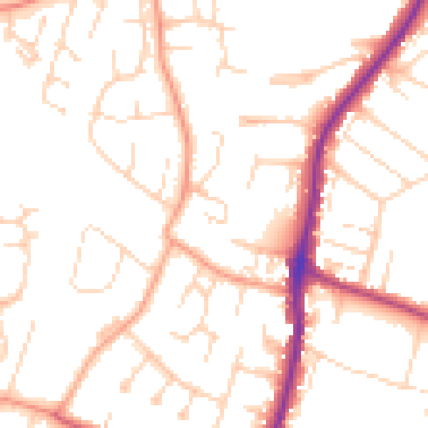
Daytime· 07:00 – 23:00
51.0dB

Night-time· 23:00 – 07:00
40.9dB