31 Abbots Way, Hartford, Northwich, CW8 1NN
About 31 Abbots Way
31 Abbots Way is a three-bedroom property in Hartford, Northwich, Northwich (CW8 1NN). It has council tax band D.
Untraded for 20 years, with the last transfer in October 2006.
Know exactly what you're buying at 31 Abbots Way
Before you offer, see what the listing won't tell you, the true value, the red flags and the full history.
Valuation
against the asking price
Risks
planning & flood
Sold prices
similar homes nearby
Trends
the local market
What this property has
Inside
- Bedrooms3
Energy performance
No EPC on record
This property doesn't have an Energy Performance Certificate yet. An EPC is required to sell or let — and unlocks our automated valuation.
Planning history
31 Abbots Way has no planning applications on record.
Notable planning nearby
2applications of note in the surrounding area
Sales history & valuation
£199,950
Recorded with HM Land Registry.
Sales timeline
10 October 2006Most recent
£199,950
Median price across the last 5 sales in CW8 1NN: £475,000 (2024–2021).
Nearby sales in CW8 1NN
29 Abbots Way, Hartford, Northwich, CW8 1NN
Sold Sept 2024
£388,9507 Abbots Way, Hartford, Northwich, CW8 1NN
Sold Jun 2024
£357,5002 Abbots Way, Hartford, Northwich, CW8 1NN
Sold Jul 2023
£495,00012 Abbots Way, Hartford, Northwich, CW8 1NN
Sold Jun 2022
£475,00025 Abbots Way, Hartford, Northwich, CW8 1NN
Sold Jun 2021
£475,000
Everything we know about 31 Abbots Way, in one report
What it's really worth, what could be wrong, and the planning, sales and area data in full.
- Am I paying too much?
- Is something wrong with it?
- Is the agent's story true?
- Will it hold its value?

Similar properties nearby
1 Chantry Avenue, Hartford
CW8 1LZ
1 Charnley Drive, Hartford
CW8 1TT
1 Beechfield Gardens, Hartford
CW8 1LQ
1 Beaufort Close, Hartford
CW8 1RX
1 Brereton Road, Hartford
CW8 1RL
1 Athelbrae Close
CW8 1EA
1 Abbey Way, Hartford
CW8 1LY
1 Abbey Lane, Hartford
CW8 1LX
The neighbourhood at a glance
Rail-style transport is unusually close for this postcode.
Crime
3/mo
Steady year-on-year across the wider district.
Nearest stop
0.4 km
Abbey Lane — bus stop.
Closest school
0.1 km
Hartford Primary School. 16 schools nearby.
Go deeper on the local area
The full report breaks down crime, transport links, schools and air quality in depth.
Road noise across the postcode
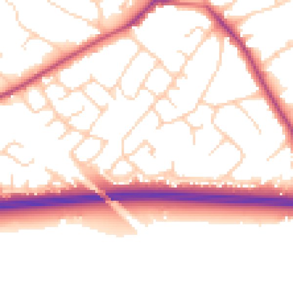
Daytime· 07:00 – 23:00
53.1dB

Night-time· 23:00 – 07:00
44.4dB