15 Balcombe Avenue, Worthing, BN14 7RU
About 15 Balcombe Avenue
15 Balcombe Avenue is a four-bedroom semi-detached house in Worthing (BN14 7RU). It has a recorded floor area of 147 m² (around 1582 sq ft), construction records dating it to 1930-1949 and council tax band D. The latest certificate (March 2017) shows a D (score 58), a step below the typical UK home. The recommended improvements would push it to C (score 78). Other recorded features include a conservatory.
At 147 m² the property is well over the postcode median (109 m² across 15 EPCs), placing it in the larger end of the local stock. One planning record on file: an extension approved in 2004. Past consents include an extension, a porch and a conservatory, meaningful when judging how the property has evolved. Last changed hands 9 years ago, in August 2017. Across 1998–2017, sale prices on this property compounded at 7% per year. Today's modelled estimate of £537,000 is 28.6% above the 2017 sale price.
What this property has
Inside
- Bedrooms4
- Dining roomYes
- CloakroomYes
- EnsuiteYes
- ConservatoryYes
Outside
- Private gardenWest-facing
- GarageYes
Everything you need to know about 15 Balcombe Avenue
The true value, the hidden risks and the full sale history, in one report.
Pick your report · every report is £14.99
One time fee only - money back guarantee

The data behind every report


Energy performance
15 Balcombe Avenue's carbon output runs well above what efficient homes in the postcode produce.
EPC Rating
Get a survey for this property
Level 2 HomeBuyer Report
We've checked 10 risk factors against the available data for this property and believe a Level 2 HomeBuyer Report could be a suitable option for you.
From £795 · Includes VAT
Planning history
1 application on record at 15 Balcombe Avenue, Worthing, BN14 7RU
- May 2004PorchFullOutcome in report
Extension: Rear of property
Erection of a conservatory to rear elevation and a front porch/w.c.
ExtensionConservatory- Reference
- 04/00389/FULL
Unlock 15 Balcombe Avenue, Worthing, BN14 7RU's full planning history
You're seeing the shape of it. The report has the substance.
- Every decision — granted, refused or withdrawn (1 on record)
- All 1 application on this property in full, plus 3 notable nearby
- What the pattern means for extending or converting here
One time fee only - money back guarantee
Sales history & valuation
Sale price has grown by over 3x since 1998.
£537,000
Modelled from EPC, postcode comparables and a sale-price growth of 7.0% per year over 20 years.
£417,500
Growth on file: 7.0% per year over 20 years.
Sales timeline
29 August 2017Most recent
£417,500
+276.1%over 19 years28 January 1998
£111,000
Median price across the last 5 sales in BN14 7RU: £498,000 (2024–2021).
Nearby sales in BN14 7RU
Versus other Balcombe Avenue homes
15 Balcombe Avenue outperforms the street on floor area by a wide margin.
Price per m²
£2,840
Street avg £3,574
Floor Area
147 m²
Street avg 110 m²
Habitable Rooms
6 rooms
Street avg 5 rooms
CO₂ Emissions
6.8 t/year
Street avg 6.2 t/year
Everything you need to know about 15 Balcombe Avenue
The true value, the hidden risks and the full sale history, in one report.
Pick your report · every report is £14.99
One time fee only - money back guarantee
The data behind every report
Similar properties nearby
1 Broomfield Avenue
BN14 7RY
1 Adversane Road
BN14 7QJ
1 Gaisford Road
BN14 7HN
1 Glebeside Avenue
BN14 7PR
1 Athelstan Road
BN14 7NA
1 Alfriston Close
BN14 7QT
1 Alfriston Road
BN14 7QU
1 Beech Gardens, Bulkington Avenue
BN14 7HL
The neighbourhood at a glance
Rail-style transport is unusually close for this postcode.
Crime
3/mo
Steady year-on-year across the wider district.
Nearest stop
0.1 km
South Farm Road — bus stop.
Closest school
0.2 km
Worthing High School. 24 schools nearby.
Go deeper on the local area
A Local Area report breaks down crime, transport links, schools and air quality in depth.
Road noise across the postcode
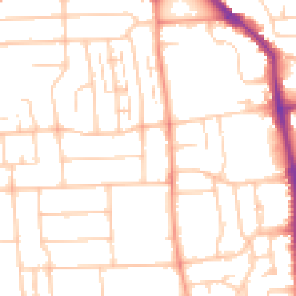
Daytime· 07:00 – 23:00
50.5dB
Night-time· 23:00 – 07:00
39.8dB