10 Kemp Road, Bournemouth, BH9 2PW
About 10 Kemp Road
10 Kemp Road is a semi-detached house in Bournemouth (BH9 2PW). It has a recorded floor area of 84 m² (around 904 sq ft) and construction records dating it to 2022. The latest certificate (August 2022) returns a B (score 84), comfortably above the UK average. The recommended improvements would push it to A (score 95).
At 84 m² it's 15.1% larger than the typical home in the postcode (73 m² median across 36 EPCs). On energy efficiency it sits in the top 10% of properties in this postcode. On a £-per-square-foot basis, the last sale (£406/sq ft) was about 91.6% above the typical sold price in the postcode. 2 planning records sit against the property, 2 approved, 0 refused. Sold June 2023 for £367,500.
Everything you need to know about 10 Kemp Road
The true value, the hidden risks and the full sale history, in one report.
Pick your report · every report is £14.99
One time fee only - money back guarantee

The data behind every report


Energy performance
10 Kemp Road ranks among the most efficient homes in the postcode for energy use.
EPC Rating
Get a survey for this property
Level 2 HomeBuyer Report
We've checked 10 risk factors against the available data for this property and believe a Level 2 HomeBuyer Report could be a suitable option for you.
From £595 · Includes VAT
Planning history
2 applications on record at 10 Kemp Road, Bournemouth, BH9 2PW
- Jun 2020New BuildFullOutcome in report
Erection of 14 dwellinghouses and 1 bungalow, formation of new vehicular access and parking spaces
- Documents
- 18 docs on file
- Reference
- 7-2020-829-K
- More recent applications — locked
- AmendmentJun 2021Decision
Unlock 10 Kemp Road, Bournemouth, BH9 2PW's full planning history
You're seeing the shape of it. The report has the substance.
- Every decision — granted, refused or withdrawn (2 on record)
- All 2 applications on this property in full, plus 71 notable nearby
- The 23 documents, officer reports & conditions
- What the pattern means for extending or converting here
One time fee only - money back guarantee
Sales history & valuation
10 Kemp Road valuation sits well clear of the typical sold price in this postcode.
£368,000
Modelled from EPC, postcode comparables.
£367,500
Recorded with HM Land Registry.
Sales timeline
4 June 2023Most recent
£367,500
Median price across the last 5 sales in BH9 2PW: £158,500 (2025–2022).
Nearby sales in BH9 2PW
Versus other Kemp Road homes
10 Kemp Road is notably below the street on years held.
Price per m²
£4,375
Street avg £2,743
Floor Area
84 m²
Street avg 91 m²
CO₂ Emissions
1.2 t/year
Street avg 3.6 t/year
Years Held
3 years
Street avg 11 years
Everything you need to know about 10 Kemp Road
The true value, the hidden risks and the full sale history, in one report.
Pick your report · every report is £14.99
One time fee only - money back guarantee
The data behind every report
Similar properties nearby
1 Bentley Road
BH9 2UE
1 Maple Road
BH9 2PN
1 Henry Joy Close
BH9 2FA
1 Melgate Close
BH9 2EE
1 Comber Road
BH9 2XG
1 Church View, Victoria Park Road
BH9 2RE
1 Elmes Road
BH9 2SX
1 Lawford Rise, Wimborne Road
BH9 2BZ
The neighbourhood at a glance
Crime
4/mo
Steady year-on-year across the wider district.
Nearest stop
0.1 km
Lidl — bus stop.
Closest school
0.5 km
St Luke's Church of England Primary School. 26 schools nearby.
Go deeper on the local area
A Local Area report breaks down crime, transport links, schools and air quality in depth.
Road noise across the postcode
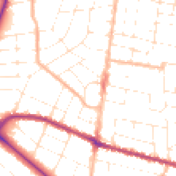
Daytime· 07:00 – 23:00
50.2dB

Night-time· 23:00 – 07:00
39.8dB