45 Cranmere Avenue, Wolverhampton, WV6 8TR
About 45 Cranmere Avenue
45 Cranmere Avenue is a four-bedroom detached house in Wolverhampton (WV6 8TR). It has a recorded floor area of 191 m² (around 2056 sq ft), construction records dating it to 1950-1966 and council tax band F. The property has underfloor heating on record, all of which lower running costs and tend to lift resale appeal. Our model identifies extension potential, subject to local planning policy. The latest certificate (November 2021) shows a D (score 61), on the cusp of jumping into the C band. The rating has held steady at D across 2 certificates since December 2014. Between certificates, wall efficiency dropped from Good to Poor and window efficiency dropped from Good to Average. The recommended improvements would push it to C (score 78).
At 191 m² it's 24.3% larger than the typical home in the postcode (154 m² median across 28 EPCs). Across 1999–2022, sale prices on this property compounded at 6.1% per year. Today's modelled estimate of £618,000 is 10.4% above the 2022 sale price. On a £-per-square-foot basis, the last sale (£272/sq ft) was about 28% above the typical sold price in the postcode. Last sale on file: £560,000 in September 2022. That sale was during the post-pandemic price surge, when transactions cleared materially above pre-2020 trend.
What this property has
Inside
- Bedrooms4
- Bathrooms2
- CloakroomYes
- StudyYes
Outside
- Private gardenYes
- GarageDouble, Detached
Building
- Underfloor heatingYes
- Extension potentialPossible
Everything you need to know about 45 Cranmere Avenue
The true value, the hidden risks and the full sale history, in one report.
Pick your report · every report is £14.99
One time fee only - money back guarantee

The data behind every report


Energy performance
45 Cranmere Avenue's carbon output runs well above what efficient homes in the postcode produce.
EPC Rating
Get a survey for this property
Level 2 HomeBuyer Report
We've checked 10 risk factors against the available data for this property and believe a Level 2 HomeBuyer Report could be a suitable option for you.
From £895 · Includes VAT
Planning history
45 Cranmere Avenue has no planning applications on record.
But the area is active
1 notable application nearby — larger schemes and conversions that could reshape the street. The report maps them all.
Sales history & valuation
45 Cranmere Avenue has more than tripled in price since its earliest registered sale in 1999.
£618,000
Modelled from EPC, postcode comparables and a sale-price growth of 6.1% per year over 23 years.
£560,000
Growth on file: 6.1% per year over 23 years.
Sales timeline
27 September 2022Most recent
£560,000
+286.2%over 22 years15 November 1999
£145,000
Median price across the last 5 sales in WV6 8TR: £400,000 (2025–2022).
Nearby sales in WV6 8TR
3 Cranmere Avenue, Wolverhampton, WV6 8TR
Sold Mar 2025
£400,00053 Cranmere Avenue, Wolverhampton, WV6 8TR
Sold Jun 2024
£660,00071 Cranmere Avenue, Wolverhampton, WV6 8TR
Sold Jun 2024
£385,0007 Cranmere Avenue, Wolverhampton, WV6 8TR
Sold Feb 2023
£400,00051 Cranmere Avenue, Wolverhampton, WV6 8TR
Sold Jun 2022
£420,000
Versus other Cranmere Avenue homes
45 Cranmere Avenue is notably below the street on years held.
Price per m²
£2,932
Street avg £2,556
Floor Area
191 m²
Street avg 171 m²
Habitable Rooms
7 rooms
Street avg 6 rooms
CO₂ Emissions
7.6 t/year
Street avg 7.5 t/year
Everything you need to know about 45 Cranmere Avenue
The true value, the hidden risks and the full sale history, in one report.
Pick your report · every report is £14.99
One time fee only - money back guarantee
The data behind every report
Similar properties nearby
1 Dippons Mill Close
WV6 8HH
1 Ashley Mount
WV6 8QD
1 Broxwood Park
WV6 8LZ
1 Edward Lisle Gardens
WV6 8UB
1 Boundary Way, Compton
WV6 8DL
1 Cherrington Gardens
WV6 8AJ
1 Bramstead Avenue
WV6 8AH
1 Birchfield Avenue
WV6 8TG
The neighbourhood at a glance
Daytime road noise here sits well below conversation level — a quiet pocket of the postcode.
Crime
5/mo
Steady year-on-year across the wider district.
Nearest stop
1.0 km
Turner Grove — bus stop.
Closest school
0.8 km
St Regis Church of England Academy. 28 schools nearby.
Go deeper on the local area
A Local Area report breaks down crime, transport links, schools and air quality in depth.
Road noise across the postcode
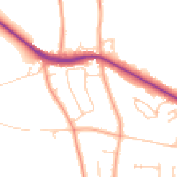
Daytime· 07:00 – 23:00
48.4dB

Night-time· 23:00 – 07:00
39.8dB