2a, Ash Tree Road, Watford, WD24 6RT
About 2a
2a is a detached house in Watford (WD24 6RT). It has a recorded floor area of 72 m² (around 775 sq ft), construction records dating it to 1950-1966 and council tax band D. The latest certificate (September 2020) shows an E (score 51), well below the UK norm with real room to improve. The recommended improvements would lift it to C (score 77), a 2-band jump.
Held since November 1997 — that's 29 years off the open market, well above the local norm. Only one transfer is on record with HM Land Registry, suggesting it has stayed in the same hands for a long time. Today's modelled estimate of £456,000 sits 424.1% above the 1997 sale of £87,000. On a £-per-square-foot basis, the last sale (£112/sq ft) was about 65% below the postcode norm. At 72 m² it's 15.3% smaller than the typical home in the postcode (85 m² median across 5 EPCs). It lags the bulk of the postcode on energy efficiency (less efficient than 80% of similar EPCs).
Everything you need to know about 2a
The true value, the hidden risks and the full sale history, in one report.
30-day money-back guarantee

The data behind every report


Energy performance
Recommended upgrades on file would lift this property by multiple EPC bands.
EPC Rating
Planning history
2a has no planning applications on record.
Notable planning nearby
4applications of note in the surrounding area
We flagged 1 thing worth checking at 2a
Independent checks surfaced things a buyer would want to understand before offering. The report explains each one in full, with the underlying data and what to ask.
- Signs of HMO activity in the area
30-day money-back guarantee
Sales history & valuation
2a's modelled value sits at over four times its earliest registered sale price (1997).
£456,000
Modelled from EPC, postcode comparables.
£87,000
Recorded with HM Land Registry.
Sales timeline
7 November 1997Most recent
£87,000
Median price across the last 5 sales in WD24 6RT: £340,000 (2024–2014).
Nearby sales in WD24 6RT
Versus other Ash Tree Road homes
2a is notably below the street on price per m².
Price per m²
£1,208
Street avg £4,945
Floor Area
72 m²
Street avg 91 m²
Habitable Rooms
3 rooms
Street avg 5 rooms
CO₂ Emissions
4.4 t/year
Street avg 4.2 t/year
Everything you need to know about 2a
The true value, the hidden risks and the full sale history, in one report.
30-day money-back guarantee
The data behind every report
Similar properties nearby
The neighbourhood at a glance
Rail-style transport is unusually close for this postcode.
Crime
4/mo
Rising year-on-year across the wider district.
Nearest stop
0.2 km
Library — bus stop.
Closest school
0.5 km
Parkgate Infants' and Nursery School. 27 schools nearby.
Go deeper on the local area
The full report breaks down crime, transport links, schools and air quality in depth.
Road noise across the postcode
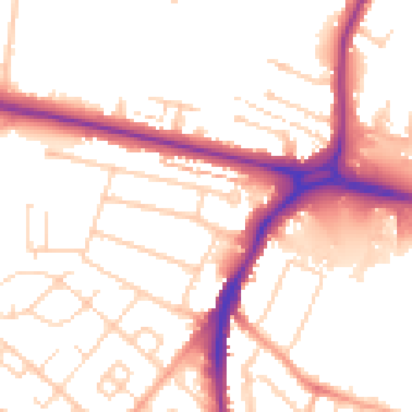
Daytime· 07:00 – 23:00
52.8dB

Night-time· 23:00 – 07:00
43.5dB