16 Hampden Way, Watford, WD17 4SS
About 16 Hampden Way
16 Hampden Way is a detached house in Watford (WD17 4SS). It has a recorded floor area of 124 m² (around 1335 sq ft), construction records dating it to 1950-1966 and council tax band E. The latest certificate (March 2020) shows a C (score 70). The recommended improvements would push it to B (score 82).
It hasn't traded since May 2002, a hold of 24 years that's notably long for the area. Today's modelled estimate of £694,000 sits 221.3% above the 2002 sale of £216,000. On a £-per-square-foot basis, the last sale (£162/sq ft) was about 48.4% below the postcode norm. 2 planning records sit against the property, 0 approved, 0 refused. At 124 m² it's 16.8% smaller than the typical home in the postcode (149 m² median across 16 EPCs).
Everything you need to know about 16 Hampden Way
The true value, the hidden risks and the full sale history, in one report.
30-day money-back guarantee

The data behind every report


Energy performance
EPC Rating
Planning history
- Mar 2023ConditionsIn report
Details submitted for Condition 4 (refuse and recycling storage), Condition 5 (hard and soft landscaping) and Condition 8 (surface water drainage details parking area) pursuant to planning permission 22/00598/FUL
- Documents
- 5 docs on file
- Reference
- 23/00070/DISCON
- Jun 2022ConditionsIn report
Details submitted for Condition 3 (Materials), 4 (Refuse and Cycle Stores), 5 (Landscaping), 6 (Tree Protection), 8 (Vehicular Access and Parking Area) pursuant to planning permission 22/00158/FUL
- Documents
- 9 docs on file
- Reference
- 22/00654/DISCON
What's in 16 Hampden Way, Watford, WD17 4SS's planning history?
Refusals, disputes and full decisions on this property and nearby, in the report.
Sales history & valuation
16 Hampden Way's estimated value is more than triple its earliest registered sale price (2002).
£694,000
Modelled from EPC, postcode comparables.
£216,000
Recorded with HM Land Registry.
Sales timeline
16 May 2002Most recent
£216,000
Median price across the last 5 sales in WD17 4SS: £1,000,000 (2024–2022).
Nearby sales in WD17 4SS
Versus other Hampden Way homes
16 Hampden Way is notably below the street on price per m².
Price per m²
£1,742
Street avg £4,639
Floor Area
124 m²
Street avg 161 m²
Habitable Rooms
6 rooms
Street avg 7 rooms
CO₂ Emissions
4.2 t/year
Street avg 5.0 t/year
Everything you need to know about 16 Hampden Way
The true value, the hidden risks and the full sale history, in one report.
30-day money-back guarantee
The data behind every report
Similar properties nearby
The neighbourhood at a glance
Crime
10/mo
Steady year-on-year across the wider district.
Nearest stop
0.3 km
Hollytree House — bus stop.
Closest school
0.3 km
Holy Rood Catholic Primary School. 22 schools nearby.
Go deeper on the local area
The full report breaks down crime, transport links, schools and air quality in depth.
Road noise across the postcode
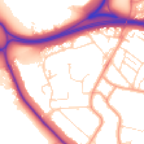
Daytime· 07:00 – 23:00
55.0dB

Night-time· 23:00 – 07:00
46.2dB